Wabeno (CDP), Wisconsin

Last updated
Wabeno, Wisconsin
Census-designated place
WabenoWisconsinDowntownWIS32.jpg
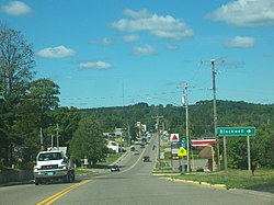
Looking north at downtown Wabeno
USA Wisconsin location map.svg
Red pog.svg
Wabeno, Wisconsin
Coordinates: 45°26′19″N88°39′37″W / 45.43861°N 88.66028°W / 45.43861; -88.66028 Coordinates: 45°26′19″N88°39′37″W / 45.43861°N 88.66028°W / 45.43861; -88.66028
Country United States
State Wisconsin
County Forest
Area
  Total2.421 sq mi (6.27 km2)
  Land2.421 sq mi (6.27 km2)
  Water0 sq mi (0 km2)
Elevation
1,539 ft (469 m)
Population
 (2010)
  Total575
  Density240/sq mi (92/km2)
Time zone UTC-6 (Central (CST))
  Summer (DST) UTC-5 (CDT)
Area code(s) 715 & 534
GNIS feature ID1580716 [1]

Wabeno is an unincorporated census-designated place located within the town of Wabeno, in Forest County, Wisconsin, United States. [2] It is located on Wisconsin Highway 32 at the eastern terminus of Wisconsin Highway 52 within the Nicolet National Forest. [2] As of the 2010 census, its population is 575. [3]

Contents

Wabeno skyline WabenoWisconsinSkylineWIS32.jpg
Wabeno skyline

History

The unincorporated community of Wabeno was built in an area where timber had been cleared by a tornado in June 1880. Wabeno was platted in 1897. [4] The town's name is derived from "waubeno" a Potawatomi word for "coming of the winds". A brief lumber boom occurred when the Chicago and North Western Railway pushed a line through the tiny town.[ when? ] In 1905, there were five sawmills in operation in Wabeno, producing 35,000,000 board feet (80,000 m3) of lumber per year. The last mill closed in 1936. [5]

Attractions

The unincorporated community of Wabeno is located 4 miles (6 km) from Northern Lights Bingo and Casino, run by the Forest County Potawatomi. For much of the year, it is possible to travel from Wabeno to Northern Lights by either snowmobile or ATV.

The Wabeno area is home to the Lumberjack Memorial Snowmobile Trails, a system that includes over 100 miles (160 km) of groomed and maintained snowmobile trails.

Other attractions in Wabeno include: an old-fashioned band shell located in the downtown green, a logging museum, a rare, and still functional, steam-powered Phoenix log hauler, a 20-foot (6.1 m) fiberglass statue of Larry the Logroller, a World War II–era Sherman tank, and a nineteenth-century log cabin still in use as the Wabeno Public Library.

Annual events include: A Memorial Day truck pull, Steam-up Days (a celebration of antique technology) in July; and the Logging Exposition and Harvest Festival on Labor Day weekend. Wabeno is the home of spring and fall dual sport motorcycle events hosted by the Wisconsin Dual Sport Riders.

Wabeno's tap water was selected as the best tasting water in the state in 2003, and this has led to the town bottling the water under the name of "Wabeno Water." [5]

Images

Related Research Articles

Vilas County, Wisconsin County in Wisconsin, United States

Vilas County is a county in the state of Wisconsin, United States. As of the 2010 census, the population was 21,430. Its county seat is Eagle River.

Ozaukee County, Wisconsin County in Wisconsin, United States

Ozaukee County is a county in the U.S. state of Wisconsin. As of the 2010 census, the population was 86,395. Its county seat is Port Washington, making it one of three Wisconsin counties on Lake Michigan not to have a county seat with the same name.

Houghton Lake, Michigan Census-designated place & unincorporated community in Michigan, United States

Houghton Lake is an unincorporated community and census-designated place (CDP) in Roscommon County in the U.S. state of Michigan. The CDP is located within Denton, Lake, and Roscommon townships. The population was 3,427 at the 2010 census.

Stanley, Wisconsin City in Wisconsin, United States

Stanley is a city in Chippewa and Clark counties in the U.S. state of Wisconsin. The population was 3,608 at the 2010 census. Of this, 3,602 were in Chippewa County, and 6 in Clark County.

Laona, Wisconsin Town in Wisconsin, United States

Laona is a town in Forest County, Wisconsin, United States. The population was 1,212 at the 2010 census. The census-designated place of Laona is located in the town. The unincorporated community of Blackwell Junction is also located partially in the town.

Wabeno, Wisconsin Town in Wisconsin, United States

Wabeno is a town in Forest County, Wisconsin, United States. The population was 1,166 at the 2010 census. The census-designated place of Wabeno and the unincorporated communities of Carter, Padus, and Soperton are located in the town. Wabeno is situated within Wisconsin's 7th congressional district.

Conover, Wisconsin Town in Wisconsin, United States

Conover is a town in Vilas County, Wisconsin, United States. The population was 1,235 at the 2010 census. The unincorporated community of Conover is located in the town.

Crandon, Wisconsin City in Wisconsin, United States

Crandon is a city in Forest County, Wisconsin, United States; it is in the northeastern part of the state, about 100 miles (160 km) north of Green Bay. The population was 1,920 at the 2010 census. It is the county seat of Forest County and is the only incorporated community in the county. The city is located adjacent to the Town of Crandon.

Fredonia (town), Wisconsin Town in Ozaukee County, Wisconsin

Fredonia is a town in Ozaukee County, Wisconsin, United States. The population was 2,903 at the 2000 census. The Village of Fredonia is surrounded by the town. The unincorporated communities of Little Kohler and Waubeka are also located in the town.

Hayward, Wisconsin City in Wisconsin, United States

Hayward is a city in Sawyer County, Wisconsin, United States, next to the Namekagon River. The population was 2,318 at the 2010 census. It is the county seat of Sawyer County. The city is surrounded by the Town of Hayward.

Kewaskum (town), Wisconsin Town in Washington County, Wisconsin

Kewaskum is a town in Washington County, Wisconsin, United States. The population was 1,119 at the 2000 census. The incorporated community of Village of Kewaskum is surrounded geographically by the Town of Kewaskum. The unincorporated community of Saint Michaels is located partially in the town.

Sayner is a census-designated place in the Town of Plum Lake in Vilas County, Wisconsin, United States. It is located at the intersection of Highway 155 and County N, about 15 miles northwest of Eagle River. As of the 2010 census, its population was 207. Sayner has an area of 1.828 square miles (4.73 km2); 1.826 square miles (4.73 km2) of this is land, and 0.002 square miles (0.0052 km2) is water. Sayner got its name from Orrin W. Sayner, who settled the area in 1891, two years before any other settlers took up homes in the town. In 1895, the Milwaukee Road extended its Valley Line north from Woodruff to Star Lake, with a stop in Sayner. The line primarily carried lumber from area forests, later carried tourists and had been abandoned in the middle 20th century.

Forest Junction, Wisconsin Census-designated place in Wisconsin, United States

Forest Junction is an unincorporated census-designated place in the town of Brillion, Calumet County, Wisconsin, United States. As of the 2010 census, its population was 616.

Laona (CDP), Wisconsin Census-designated place in Wisconsin, United States

Laona is an unincorporated census-designated place in the town of Laona in Forest County, Wisconsin, United States. U.S. Route 8 travels east–west through the community and Wisconsin Highway 32 travels south and west of the community. The community park has a sign stating that the community donated the 1979 Christmas tree at the nation's capitol. As of the 2010 census, its population is 583.

Soperton is an unincorporated community located within the town of Wabeno, in Forest County, Wisconsin, United States.

Mountain (CDP), Wisconsin Census-designated place in Wisconsin, United States

Mountain is an unincorporated census-designated place in Oconto County, Wisconsin, United States. The community is located at the intersection of Wisconsin Highway 32 and Wisconsin Highway 64, in the town of Mountain. It is located at latitude 45.185 and longitude -88.474 and elevation 971 feet. The postal code for Mountain is 54149. As of the 2010 census, its population is 363. Mountain has an area of 6.699 square miles (17.35 km2), all of it land.

Drummond is an unincorporated, census-designated place located in the town of Drummond, Bayfield County, Wisconsin, United States.

Mercer (CDP), Wisconsin Census-designated place in Wisconsin, United States

Mercer is an unincorporated census-designated place located in the town of Mercer, Iron County, Wisconsin, United States. Mercer is located on U.S. Route 51 20.5 miles (33.0 km) south-southeast of Hurley. Mercer has a post office with ZIP code 54547. As of the 2010 census, its population is 516.

Hiles (community), Wisconsin Unincorporated community in Wisconsin, United States

Hiles is an unincorporated community in the town of Hiles, Forest County, Wisconsin, United States. Hiles is located on Wisconsin Highway 32 10 miles (16 km) north-northwest of Crandon.

Donald, Wisconsin Unincorporated community in Wisconsin, United States

Donald is an unincorporated community located in the town of Pershing, Taylor County, Wisconsin, United States, where the Canadian National Railway crosses County Highway M.

References

  1. U.S. Geological Survey Geographic Names Information System: Wabeno (CDP), Wisconsin
  2. 1 2 "Wabeno Profile". Wisconsin Hometown Locator. Retrieved 21 February 2010.
  3. "U.S. Census website". U.S. Census Bureau . Retrieved 20 April 2011.
  4. Chicago and North Western Railway Company (1908). A History of the Origin of the Place Names Connected with the Chicago & North Western and Chicago, St. Paul, Minneapolis & Omaha Railways. p. 134.
  5. 1 2 "Winter Recreation". www.forestcountywi.com. Archived from the original on 2002-12-12.