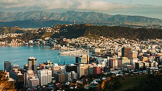
Wellington is the capital city of New Zealand. It is located at the south-western tip of the North Island, between Cook Strait and the Remutaka Range. Wellington is the third-largest city in New Zealand, and is the administrative centre of the Wellington Region. It is the world's southernmost capital of a sovereign state. Wellington features a temperate maritime climate, and is the world's windiest city by average wind speed.

Waitangi Day, the national day of New Zealand, marks the anniversary of the initial signing—on 6 February 1840—of the Treaty of Waitangi. The Treaty of Waitangi was an agreement towards British sovereignty by representatives of the Crown and indigenous Māori chiefs, and so is regarded by many as the founding document of the nation.
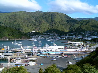
Picton is a town in the Marlborough Region of New Zealand's South Island. The town is located near the head of the Queen Charlotte Sound / Tōtaranui, 25 km (16 mi) north of Blenheim and 65 km (40 mi) west of Wellington. Waikawa lies just north-east of Picton and is considered to be a contiguous part of the Picton urban area.
Wellington Harbour, officially called Wellington Harbour / Port Nicholson, is a large natural harbour on the southern tip of New Zealand's North Island. The harbour entrance is from Cook Strait. Central Wellington is located on parts of the western and southern sides of the harbour, and the suburban area of Lower Hutt is to the north and east.

New Lynn is a residential suburb in West Auckland, New Zealand, located 10 kilometres to the southwest of the Auckland city centre. The suburb is located along the Whau River, one of the narrowest points of the North Island, and was the location of Te Tōanga Waka, a traditional waka portage between the Waitematā and Manukau harbours.

The Hibiscus Coast is a populated area on a stretch of the Hauraki Gulf coast in New Zealand's Auckland Region. It has a population of 64,660, making it the 10th most populous urban area in New Zealand, and the second most populous in the Auckland Region, behind Auckland itself. As an urban area delineated by Statistics New Zealand, the Hibiscus Coast consists of Hatfields Beach, Orewa, Silverdale and Whangaparāoa Peninsula. The Auckland Council's Hibiscus Coast subdivision of the Hibiscus and Bays includes the neighbouring communities of Waiwera and Stillwater, and Milldale in Rodney, is also described as a part of the Hibiscus Coast.
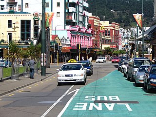
Te Aro is an inner-city suburb of Wellington, New Zealand. It comprises the southern part of the central business district including the majority of the city's entertainment district and covers the mostly flat area of city between The Terrace and Cambridge Terrace at the base of Mount Victoria.

The Auckland isthmus, also known as the Tāmaki isthmus, is a narrow stretch of land on the North Island of New Zealand in the Auckland Region, and the location of the central suburbs of the city of Auckland, including the CBD. The isthmus is located between two rias : the Waitematā Harbour to the north, which opens to the Hauraki Gulf / Tīkapa Moana and Pacific Ocean, and the Manukau Harbour to the south, which opens to the Tasman Sea. The isthmus is the most southern section of the Northland Peninsula.

The Auckland Central Business District (CBD), or Auckland city centre, is the geographical and economic heart of the Auckland metropolitan area. It is the area in which Auckland was established in 1840, by William Hobson on land gifted by mana whenuahapū Ngāti Whātua Ōrākei. It is New Zealand's leading financial hub, and the centre of the country's economy; the GDP of the Auckland Region was NZD$139 billion in the year ending September 2023.

Frank Kitts Park is a public park situated between Jervois Quay and the Lambton Harbour waterfront in Wellington, New Zealand. It is named after Sir Frank Kitts, New Zealand politician and mayor of Wellington.

Auckland is a large metropolitan city in the North Island of New Zealand. It has an urban population of about 1,478,800. It is located in the greater Auckland Region, the area governed by Auckland Council, which includes outlying rural areas and the islands of the Hauraki Gulf, and which has a total population of 1,739,300 as of June 2023. It is the most populous city of New Zealand and the fifth largest city in Oceania. While Europeans continue to make up the plurality of Auckland's population, the city became multicultural and cosmopolitan in the late-20th century, with Asians accounting for 31% of the city's population in 2018. Auckland has the fourth largest foreign-born population in the world, with 39% of its residents born overseas. With its large population of Pasifika New Zealanders, the city is also home to the biggest ethnic Polynesian population in the world. The Māori-language name for Auckland is Tāmaki Makaurau, meaning "Tāmaki desired by many", in reference to the desirability of its natural resources and geography. Tāmaki means "omen".

Battle Hill Farm Forest Park is a regional park near Paekākāriki, in the Kāpiti Coast District and Wellington Region of New Zealand's lower North Island.

Belmont Regional Park is a regional park located between Lower Hutt and Porirua, in the Wellington Region at the southern end of New Zealand's North Island. It is administered by Wellington Regional Council. It was the first park in New Zealand to include land for recreation, conservation and farming.
Te Raukura, otherwise known as Te Wharewaka o Poneke is a building located on Taranaki Street Wharf, Wellington waterfront, New Zealand. It houses a conference venue, Karaka Cafe, and waka house.

Ngāti Whātua Ōrākei or Ngāti Whātua-o-Ōrākei is an Auckland-based Māori hapū (sub-tribe) in New Zealand. Together with Te Uri-o-Hau, Te Roroa and Te Taoū, it comprises the iwi (tribe) of Ngāti Whātua. These four hapū can act together or separately as independent tribes. The hapū's rohe is mostly in Tāmaki Makaurau, the site of present-day Auckland. Ngāti Whātua Ōrākei has around 6,000 members whose collective affairs are managed by the Ngāti Whātua Ōrākei Trust.
Megan Mary Wraight was a New Zealand landscape architect who had considerable influence on the design of public spaces. She was the founding principal of Wraight + Associates Limited, which has completed a wide variety of large-scale urban projects throughout New Zealand, including waterfront redevelopments, educational facilities, transport facilities and urban-renewal projects.

The Wairarapa Moana Wetlands are a major wetland, located in the South Wairarapa District in the Wellington Region at the southern end of New Zealand's North Island.

Portages in New Zealand, known in Māori as Tō or Tōanga Waka, are locations where waka (canoes) could easily be transported overland. Portages were extremely important for early Māori, especially along the narrow Tāmaki isthmus of modern-day Auckland, as they served as crucial transportation and trade links between the east and west coasts. Portages can be found across New Zealand, especially in the narrow Northland and Auckland regions, and the rivers of the Waikato Region.
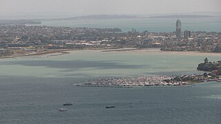
Shoal Bay is a bay of the Waitematā Harbour in Auckland, New Zealand. It is located on the North Shore.

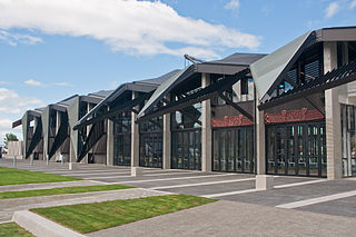
New Lynn War Memorial Library is a public library located in New Lynn, West Auckland, New Zealand. Opening in 1956 as part of a planned community centre precinct and World War I memorial, the original library was demolished and redeveloped in 2005. Memorial Square at the entrance to the museum was redeveloped in 1998 to a design by landscape architect Megan Wraight. The square incorporates brick columns and a sunken waka sculpture, added in 2000 and designed by Te Kawerau ā Maki carvers Sunnah Thompson and Rewi Spraggon.


