The Tuapeka River is located in Otago in the South Island of New Zealand. It is a tributary of the Clutha River, which it joins at Tuapeka Mouth between Roxburgh and Balclutha.

Clutha District is a local government district of southern New Zealand, with its headquarters in the Otago town of Balclutha. The Clutha District has a land area of 6,362.86 km² and a 2006 census population of 16,839 usual residents. Clutha District occupies the majority of the geographical area known as South Otago.
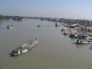
The Turag River is the upper tributary of the Buriganga, a major river in Bangladesh. The Turag originates from the Bangshi River, the latter an important tributary of the Dhaleshwari River, flows through Gazipur and joins the Buriganga at Mirpur in Dhaka District. It is navigable by boat all year round.
Titiroa is a locality in the Southland Region of New Zealand's South Island. It is on the eastern bank of the lower Mataura River, inland from Toetoes Bay. Pine Bush is nearby to the northeast, and Waimahaka is to the southeast.

Finegand is a locality in the South Otago region of New Zealand's South Island.
Ashton is a lightly populated locality in the Canterbury Region of New Zealand's South Island. It is situated on the Canterbury Plains south of Ashburton, on the Pacific Ocean coastline. It is on the southern side of the Ashburton River's mouth. Nearby settlements include Huntingdon and Wheatstone to the north, Waterton to the southwest, and across the Ashburton River, Riverside to the northeast.
Prince Edward Glacier is a glacier draining the north side of Cotton Plateau in the Queen Elizabeth Range and flowing north for about 6 nautical miles (11 km) along the west side of Hochstein Ridge. Named by New Zealand Antarctic Place-Names Committee (NZ-APC) for Prince Edward, Earl of Wessex, son of Elizabeth II of the United Kingdom.
Paşaoba is a village and municipality in the Quba Rayon of Azerbaijan. It has a population of 993.
The Fish River, New Zealand is a river in the Otago Region of New Zealand. A tributary of the Makarora River, it rises east of Mount Burke and flows south-eastward through Mount Aspiring National Park, crossing State Highway 6 at 44° 6.97'S 169° 20.66'E, to join that river south of Haast Pass.
The Ohinetamatea River is a river in the Westland District of New Zealand. It is also known as Saltwater Creek in the lower reaches.
The Otoko River is a river of the West Coast Region of New Zealand's South Island. It flows generally northwest from the northern slopes of Mount Hooker, reaching the Paringa River 20 kilometres south of Bruce Bay.
The Puerua River is a river in South Otago, New Zealand. A tributary of the Clutha River, it rises east of Brown Dome and flows eastward to join that river near Port Molyneux.
The Waipati River, alternatively known as the Chaslands River is a river in the eastern Catlins, New Zealand. It rises in the Maclennan Range and flows south-eastward into the Waipati Beach north of Chaslands Mistake.
The Waitahuna River is a river in New Zealand, a tributary of the Clutha River.

Baker Glacier is a small tributary glacier that enters Whitehall Glacier just north of Martin Hill, in the Victory Mountains of Victoria Land, Antarctica. It was mapped by the United States Geological Survey from surveys and from U.S. Navy air photos, 1960–62, and named by the Advisory Committee on Antarctic Names for John R. Baker, biologist at Hallett Station in 1967–68 and 1968–69.
Football Saddle is a broad pass at 700 metres (2,300 ft), 2 nautical miles (4 km) east-southeast of Football Mountain on the ridge between Edisto Inlet and Tucker Glacier in Antarctica. The pass is an all-snow route that can be crossed by sledge, but there are two other saddles close east and west of Football Mountain that are no higher and are more easily crossed on foot, though more difficult by sledge because they are steeper and have stretches of bare rock. It was so named by the New Zealand Geological Survey Antarctic Expedition, 1957–58, because of its proximity to The Football.
Morris Glacier is a glacier in Antarctica, 10 nautical miles (19 km) long, which drains north from Mount Daniel to the Ross Ice Shelf between the Lillie Range and Clark Spur. It was named by the southern party of the New Zealand Geological Survey Antarctic Expedition of 1963–64 for Commander Marion E. Morris, U.S. Navy, Executive Officer of Squadron VX-6, who piloted the aircraft which flew the party's reconnaissance.
The Rush Creek, a perennial stream of the Hawkesbury-Nepean catchment, is located in the Outer Metropolitan Sydney region of New South Wales, Australia.
The Webbs Creek, a perennial stream of the Hawkesbury-Nepean catchment, is located in the Outer Metropolitan Sydney region of New South Wales, Australia.


