Mineral County is a county located in the U.S. state of Nevada. As of the 2020 census, the population was 4,554, making it the fifth-least populous county in Nevada. Its county seat is Hawthorne.
Gages Lake is a census-designated place (CDP) in Warren Township, Lake County, Illinois, United States. The population was 10,637 at the 2020 census.

Silver Springs is a census-designated place (CDP) in Lyon County, Nevada, United States at the intersection of US 50 and US 95A. The population was 5,296 at the 2010 census. Lahontan Reservoir, Lahontan State Recreation Area and historic Fort Churchill State Historic Park are all located nearby. The area is served by the Silver Springs Airport.

Smith Valley is a census-designated place (CDP) in Lyon County, Nevada, United States. The population was 1,603 at the 2010 census.

Hawthorne is an unincorporated community and census-designated place (CDP) in Mineral County, Nevada, United States. As of the 2020 census, the population was 3,118. It is the county seat of Mineral County. The nearby Hawthorne Army Depot is the primary economic base of the town.

Schurz is an unincorporated community and census-designated place (CDP) in Mineral County, Nevada, United States. The population was 656 at the 2020 census. It is located on the Walker River Indian Reservation and is the burial place of Wovoka, the Paiute messiah who originated the Ghost Dance movement.
Lake Norman of Catawba is a census-designated place (CDP) in Catawba County, North Carolina, United States. The population was 11,395 at the 2020 census up from 7,411 at the 2010 census. It is part of the Hickory-Lenoir-Morganton Metropolitan Statistical Area.

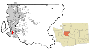
Lakeland North is a census-designated place (CDP) in King County, Washington, United States. The population was 13,663 at the 2020 census. Part of the community was annexed into neighboring Auburn in 2008.

Bridgeport is an unincorporated community and census-designated place (CDP) in Mono County, California, United States. It is the Mono county seat. The population was 553 at the 2020 census.

Mina is an unincorporated community and census-designated place (CDP) in Mineral County in west-central Nevada, United States. It is located along U.S. Route 95 at an elevation of 4,560 feet (1,390 m). The population at the 2020 census was 127.

Meadview is an unincorporated community and census-designated place (CDP) in Mohave County, Arizona, United States, located near Lake Mead. As of the 2020 census, Meadview had 1,420 residents, up from 1,224 as of 2010. It was founded in the 1960s as a retirement community and is still largely one, as well as a vacation spot for people coming to enjoy Lake Mead.

Glenbrook is a census-designated place (CDP) on the east shore of Lake Tahoe in Douglas County, Nevada, United States. The population was 215 at the 2010 census. Beach and Bay are for residents and renters living in Glenbrook's gated community. There is no public access to the beach or bay.
Topaz Lake is a census-designated place (CDP) in Douglas County, Nevada, United States. The population was 157 at the 2010 census.
Topaz is an unincorporated community and census-designated place (CDP) in Mono County, California, United States. It is located 3 miles (5 km) north of Coleville, at an elevation of 5,033 feet (1,534 m). Topaz's ZIP Code is 96133. The population was 150 at the 2020 census.

Walker is an unincorporated community and census-designated place (CDP) in Mono County, California, United States. It is located 3 miles (5 km) south of Coleville, at an elevation of 5,403 feet (1,647 m). The ZIP Code is 96107, and mail to Walker should be addressed Coleville.
Lakeridge is a census-designated place (CDP) in Douglas County, Nevada, United States. The population was 371 at the 2010 census.
Logan Creek is a census-designated place (CDP) on the east shore of Lake Tahoe in Douglas County, Nevada, United States. The population was 26 at the 2010 census.

Round Hill Village is a census-designated place (CDP) in northwestern Douglas County, Nevada, United States. The population was 759 at the 2010 census. Prior to 2010, the community was part of the Zephyr Cove–Round Hill Village CDP.
Skyland is a census-designated place (CDP) in Douglas County, Nevada, United States. The population was 376 at the 2010 census.
Conesus Lake is a hamlet and census-designated place (CDP) in Livingston County, New York, United States. Its population was 2,584 as of the 2010 census. The community is located in the towns of Geneseo, Livonia, Groveland, and Conesus and covers Conesus Lake, the westernmost of New York's Finger Lakes, and nearly all of the lake's shoreline communities.


