Country
According to Norman Tindale, the Wangaibon's traditional lands extended over some 27,000 sq. miles of territory, taking in the headwaters of the Bogan River, the Tigers Camp and Boggy Cowal creeks. Their area encompassed Trida, Narromine, Nyngan, Girilambone, Cobar, and Gilgunnia. The western boundary lay around Ivanhoe and near the Neckarboo Range. Their southern borders ran to Trundle. When severe drought struck they were known to venture into Wiradjuri land, to their west, on the Lachlan River and Little Billabong Creek.

Norman Barnett Tindale AO was an Australian anthropologist, archaeologist, entomologist and ethnologist.
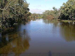
Bogan River, a perennial river that is part of the Macquarie–Barwon catchment within the Murray–Darling basin, is located in the central west and Orana regions of New South Wales, Australia.
Trida is a locality in Central Darling Shire in the Far West region of New South Wales, Australia.
Social organization
According to an early observer, A. L. P. Cameron, the Wangaibon's social divisions were as follows:
| classes | Totems |
|---|
| Ipai | wagun (crow) |
| Kumbu | murua (kangaroo) |
| Murri | tali (iguana) |
| Kubbi | kuru (bandicoot); kurakai (opossum) |
|
The Wangaibon intermarried with the Wiradjuri, and the marriage pattern, again according to Cameron, was as follows::
The Wiradjuri people are a group of Indigenous Australian Aboriginal people that were united by a common language, strong ties of kinship and survived as skilled hunter–fisher–gatherers in family groups or clans scattered throughout central New South Wales.
| Male | Marries | Children are |
|---|
| (M) Ipai | (F) Matha | Kubbi/Kubbitha |
| (M) Kumbu | (F) Kubbitha | Murri/Matha. |
| (M) Murri | (F) Ipatha | Kumbu/Butha. |
| (M) Kubbi | (F) Butha | Ipai/Ipatha. |
Cameron elsewhere states that Ipatha, Butha, Matha and Kubbitha were the famel equivalents of Ipai, Kumbu, Murri and Kubbi.
There were five grades classified for the ages of man: a boy was eramurrung; bimbadjeri during the initiatory months; then bigumjeri. On reaching middle age, he became gibera and in old age giribung.:
Lore
According to a Wangaibon story, the emu once had enormous wings, and, flying high, grew curious at the sight of numerous birds engaged in fishing in a lake. On its descent, the other species flew off in alarm, save for the brolga or native companion. The emu inquired about how it might learn the craft of fishing, and the brolga, with treacherous mischief in mind, told it that in order to trawl up fish, it would have to have its immense wings removed which, on the emu consenting, the native companion set about doing, and, once the shearing was completed, scorned the emu, which was now deprived of flight. On meeting up again after many years, it turned out the emu had a brood of ten chicks, while the brolga had only one. The brolga apologized for her bad behaviour and was forgiven. But, unable to change her malicious ways, she jumped at the excuse provided by the emu's admission it was hard to feed her nurslings, by suggesting they eat them. Once more the emu was inveigled into accepting the brolga's advice, only, once the latter had gorged itself, to be cajoled for its stupidity in having its young killed. On a third occasion, the brolga, seeing the emu on a brood of 10 eggs, tried to get them, but was fended off as the emu rushed off the nest and charged the native companion. It in turn, leapt at the opportunity to smash the eggs by dropping down from the sky. Only one remained intact. The outraged emu, finding nothing to throw at her antagonist, took this last egg and launched it after the brolga as it flew high into the sky. It hit its target, and, as it broke, formed the sun.
This page is based on this
Wikipedia article Text is available under the
CC BY-SA 4.0 license; additional terms may apply.
Images, videos and audio are available under their respective licenses.
The Barindji, also written Parrintyi, are an indigenous Australian people of the state of New South Wales. They are to be neatly distinguished from the Paaruntyi, who spoke a similar language but whom they called the spitting people.

The Overflow is a bounded rural locality, cadastral parish and Sheep station, 100 kilometers south of Nyngan, New South Wales. It is located at 32°12′05″S 146°38′31″E on Gunningbar Creek near the junction with the Bogan River and is in Bogan Shire and Flinders County. The locality is 32 kilometers south of the town of Nymagee, and west of Tottenham, New South Wales.
Grahway is a bounded rural locality, and cadastral parish, 100 kilometers south of Nyngan, New South Wales. It is located at 32°12′05″S 146°38′31″E on Gunningbar Creek near the junction with the Bogan River and is in Bogan Shire and Flinders County.The locality is 32 kilometers south of the town of Nymagee, and west of Tottenham, New South Wales.
Delby' is a bounded rural locality, and cadastral parish, 100 kilometers south of Nyngan, New South Wales. It is located at 32°15′57″S 146°43′29″E on Gunningbar Creek near the junction with the Bogan River and is in Bogan Shire and Flinders County. The locality is south of the town of Nymagee, and west of Tottenham, New South Wales.
Walton is a bounded rural locality, and cadastral parish, 100 kilometers south of Nyngan, New South Wales. It is located at 32°10′26″S 146°34′16″E on Gunningbar Creek near the junction with the Bogan River and is in Bogan Shire and Flinders County. The locality is south of the town of Nymagee, and west of Tottenham, New South Wales.
The Tulua were an indigenous Australian tribe of Queensland.
The Kwatkwat were an indigenous Australian tribe of the State of Victoria, though some scholars consider them part of the broader Yorta Yorta/Pangerang macrogroup.
The Gunggari are an indigenous Australian people of southern Queensland. They are to be distinguished from the Kuungkari.
The Kuungkari are an indigenous Australian people of Queensland. They are to be distinguished from the Kunggari.
The Ngiyampaa also known as the Ngemba, are an indigenous Australian people of the state of New South Wales.
The Kwiambal were an indigenous Australian people of New South Wales.
The Punthamara were an indigenous Australian people of the state of Queensland.
The Mian were an indigenous people of the state of Queensland.
The Karingbal (Garaynbal) are an indigenous Australian people of the state of Queensland. They spoke a dialect of Biri.
The Jeithi were an indigenous Australian people of the state of New South Wales.
The Kawambarai (Gawambaraay) were an indigenous Australian people of the state of New South Wales. Their domain was in the central–western district of New South Wales
The Paaruntyi are an indigenous Australian people of the state of New South Wales. They are not to be confused with the Parrintyi.

Elinginbah, New South Wales is a rural locality of Bogan Shire and a civil parish of Oxley County, New South Wales, a Cadastral divisions of New South Wales.
