
Bolton is a town in Greater Manchester in England. In the foothills of the West Pennine Moors, Bolton is between Manchester, Blackburn, Wigan, Bury and Salford. It is surrounded by several towns and villages that form the wider borough, of which Bolton is the administrative centre. The town is also within the historic county boundaries of Lancashire.

Horwich is a town and civil parish in the Metropolitan Borough of Bolton, Greater Manchester, England, within the Historic County Boundaries of Lancashire. It is 5.3 miles (8.5 km) southeast of Chorley, 5.8 miles (9.3 km) northwest of Bolton and 15 miles (24 km) northwest of Manchester. It lies at the southern edge of the West Pennine Moors with the M61 motorway passing close to the south and west. At the 2011 Census, Horwich had a population of 20,067.
Blue Lagoon may refer to:

United Utilities Group plc (UU) is the United Kingdom's largest listed water company. It was founded in 1995 as a result of the merger of North West Water and NORWEB. The group manages the regulated water and waste water network in North West England, which includes Cumbria, Greater Manchester, Lancashire, Merseyside, most of Cheshire and a small area of Derbyshire, which have a combined population of more than seven million.

Anglezarke is a sparsely populated civil parish in the Borough of Chorley in Lancashire, England. It is an agricultural area used for sheep farming and is also the site of reservoirs that were built to supply water to Liverpool. The area has a large expanse of moorland with many public footpaths and bridleways. The area is popular with walkers and tourists; it lies in the West Pennine Moors in Lancashire, sandwiched between the moors of Withnell and Rivington, and is close to the towns of Chorley, Horwich and Darwen. At the 2001 census it had a population of 23, but at the 2011 census the population was included within Heapey civil parish. The area was subjected to depopulation after the reservoirs were built.

Belmont is a village and former civil parish, now in the parish of North Turton, in the unitary authority area of Blackburn with Darwen, in the ceremonial county of Lancashire, England. It is close to Darwen and has around 500 inhabitants.

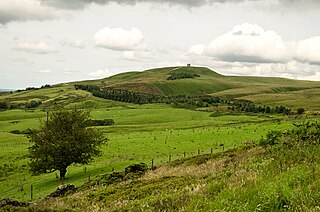
Rivington Pike is a hill on Winter Hill, part of the West Pennine Moors at Rivington, Chorley in Lancashire, England. The nearest towns are Adlington and Horwich. The land and building are owned and managed by Chorley Council. The Pike Tower is a prominent local landmark and is located at the summit, it is part of Lever Park. The area is popular with hill walkers and for mountain biking.

Rishton is a town in the Hyndburn district of Lancashire, England, about 2 miles (3 km) west of Clayton-le-Moors and 4 miles (6 km) north east of Blackburn. It was an urban district from about 1894 to 1974. The population at the census of 2011 was 6,625.
Rivington is a village and civil parish of the Borough of Chorley, Lancashire, England, occupying 2,538 acres. It is about 6 miles (9.7 km) southeast of Chorley and about 8+1⁄2 miles (13.7 km) northwest of Bolton. Rivington is a rural area consisting primarily of agricultural grazing land, moorland, with hill summits including Rivington Pike and Winter Hill within the West Pennine Moors. The area has a thriving tourist industry centred around reservoirs created to serve Liverpool in the Victorian era and Lever Park created as a public park by William Lever at the turn of the 20th century, with two converted barns, a replica of Liverpool Castle and open countryside. Rivington and Blackrod High School is located here. Rivington and its village had a population of 109 at the 2011 Census.

The West Pennine Moors is an area of the Pennines covering approximately 90 square miles (230 km2) of moorland and reservoirs in Lancashire and Greater Manchester, England. It is a Site of Special Scientific Interest.

Heapey is a village and civil parish of the Borough of Chorley, in Lancashire, England. The village is two miles from Chorley and on the western fringe of the West Pennine Moors. In 2001 the population was 955, increasing to 1,001 at the 2011 census.

Breightmet is a neighbourhood of Bolton, in Greater Manchester, England. The population of the ward taken at the 2011 census was 13,584. Historically a township of the civil and ecclesiastical parish of Bolton le Moors in the Salford hundred of Lancashire, it lies 2 miles (3.2 km) north-east of Bolton and 4 miles (6.4 km) north-west of Bury.

Edgworth is a small village within the borough of Blackburn with Darwen, Lancashire, England. It is north east of North Turton between Broadhead Brook on the west and Quarlton Brook in the south east. The ground ranges from 650 feet (200 m) to 1,100 feet (340 m) above sea level.
Turton is a historical area in the North West of England. It is divided between the ceremonial counties of Lancashire and Greater Manchester. The Turton area is located north of Bolton and south of Blackburn. The area historically formed a township in the ancient parish of Bolton le Moors. The principal village in the township is now known as Chapeltown.

Bromley Cross is a residential area of South Turton in the Metropolitan Borough of Bolton, Greater Manchester, England. It gives its name to a larger electoral ward, which includes Eagley, Egerton, and Cox Green. Historically part of Lancashire, Bromley Cross lies on the southern edge of the West Pennine Moors.
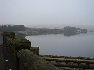
Wayoh Reservoir is a water reservoir in the town of Edgworth, Lancashire, England. It was completed on 28 April 1876 to supply water to Bolton. Wayoh, together with the Turton and Entwistle Reservoir, make up 50% of Bolton's drinking water.
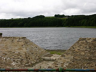
Turton and Entwistle Reservoir is a water reservoir in the village of Edgworth, Lancashire, England. The reservoir's existence is due to the Entwistle Dam. When constructed in 1832 the Entwistle Dam was the highest in Britain; it rises 108 feet from the base. The reservoir contains almost 750 thousand imperial gallons and, with the Wayoh Reservoir just below, satisfies around 50% of Bolton's need for drinking water.
Belmont Reservoir is a reservoir north of the small moorland village of Belmont, Lancashire, England, fed by the Belmont Brook. It was built in 1826 by the Bolton Waterworks to supply water to the rapidly expanding town of Bolton. Belmont was once a thriving industrial centre for stone quarrying and printing. The reservoir is the home of the Bolton Sailing Club. The reservoir is important to wintering wildfowl.
Sharples, a suburb of Bolton, was a township of the civil and ecclesiastical parish of Bolton le Moors in the Salford hundred of Lancashire, England. It lay 2+1⁄2 miles north of Bolton. It contained the smaller settlements of Banktop, Sweet-Loves, High-Houses, Gale, Folds, Belmont, Piccadilly, Water-Meetings, Old Houses and part of Astley Bridge.

Terraced Gardens of Rivington is a landscaped woodland on the hillside of Rivington Pike, in Rivington Parish in the Chorley Borough of Lancashire, England, originally designed as a Garden by T.H. Mawson and built as curtilage to a home of the soap magnate Viscount Leverhulme; as such, the area is not part of Lever Park. The gardens contains and abuts the SSSI of the West Pennine Moors. Today the former gardens are Grade II listed and contain eleven Grade II structures. The original design had three elements — the upper part being in the romanesque architectural style, the lower section, known as the Ravine, was a woodland with a man-made stream, and a Japanese-style garden, with a man-made pond constructed of Pulmonite which remains today. The gardens are leased to Rivington Heritage Trust by United Utilities and are undergoing restoration and preservation.

