
Poulton-le-Fylde, commonly shortened to Poulton, is a market town in Lancashire, England, situated on the coastal plain called the Fylde. In the 2021 United Kingdom census, it had a population of 18,115.

Fleetwood is a coastal town in the Borough of Wyre in Lancashire, England, at the northwest corner of the Fylde. It had a population of 25,939 at the 2011 census.
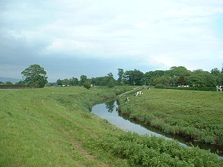
The River Wyre, in Lancashire, England, flows into the Irish Sea at Fleetwood. It is 28 miles (45 km) long and has a sheltered estuary which penetrates deep into the Fylde peninsula.

Hambleton is a village and civil parish in the English county of Lancashire. It is situated on a coastal plain called the Fylde and in an area east of the River Wyre known locally as Over Wyre. Hambleton lies approximately 3 miles (4.8 km) north-east of its post town, Poulton-le-Fylde, and about 7 miles (11 km) north-east of the seaside resort of Blackpool. In the 2001 United Kingdom census, the parish had a population of 2,678, increasing to 2,744 at the 2011 census.
The Fylde is a coastal plain in western Lancashire, England. It is roughly a 13-mile-long (21-kilometre) square-shaped peninsula, bounded by Morecambe Bay to the north, the Ribble estuary to the south, the Irish Sea to the west, and the foot of the Bowland hills to the east which approximates to a section of the M6 motorway and West Coast Main Line.

Stalmine is a village in the civil parish of Stalmine-with-Staynall, in the Wyre borough of Lancashire, England, in a part of the Fylde known as Over Wyre. The village is located on a small hill on the A588, the main road between Hambleton and Lancaster, with the highest level 75 ft above sea level. The village name has been spelled Stalmin and Stalemynne. The village had a population of 1,087 at the 2011 Census.

Stalmine-with-Staynall is a civil parish within the Wyre borough of Lancashire, England, in a part of the Fylde known as Over Wyre. The parish contains the village of Stalmine and the hamlets of Staynall and Wardleys. The civil parish had a population of 1,486 at the 2011 Census, of which 1,087 lived in Stalmine village.
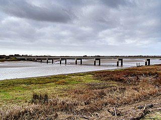
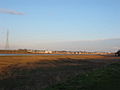
Shard Bridge is a bridge in the English county of Lancashire. It spans the River Wyre, connecting Singleton, on the southern side of the river, to Hambleton, on its northern side, carrying both automotive and pedestrian traffic of the A588 Shard Road. The word shard is a Roman term for "low crossing point on a river".

Burn Naze is a residential area of Thornton-Cleveleys, in the Borough of Wyre, Lancashire, England. It is located about 5 miles (8 km) northeast of Blackpool and 2 miles (3 km) southeast of Fleetwood. Cleveleys is about 1.3 miles (2.1 km) to the west, while the River Wyre is about 0.8 miles (1.3 km) to the east.

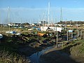
Skippool is an area of Thornton-Cleveleys, Lancashire, England. It is situated between Little Thornton and Poulton-le-Fylde along the western banks of the River Wyre, about 3 miles (4.8 km) south of its mouth between Fleetwood and Knott End. These banks are known as Skippool Creek, an historic docks area now home to mostly run-down vessels. The MV Good Hope, for example, may date from the 1830s. Skippool Creek is a short branch off Main Dyke, which empties into the River Wyre in front of Blackpool and Fleetwood Yacht Club.

The River House is an historic building in the Skippool area of Thornton-Cleveleys, Lancashire, England. Overlooking the River Wyre, it was built in 1830, originally known as Wyre Bank, later becoming Wyre Bank Hotel and Restaurant. After two further renamings, firstly to The River House, then TheRiver House Restaurant, in 1958, it was frequented by the likes of Rudolf Nureyev, George Harrison and prominent politicians and was run by members of the Scott family. It has also been a four-guestroom hotel.

Shard Riverside Inn is a public house and boutique hotel in the English village of Hambleton, Lancashire. Dating to 1766, it stands on the northern banks of the River Wyre, about 600 feet (180 m) east of Shard Bridge, for which it is named. The bridge used to be immediately to the west of the building, but a new structure was built in 1993, a few yards downstream, and its predecessor demolished. The building's address, Old Bridge Lane, references this.

The Burn Naze was a public house in Burn Naze, Lancashire. Built in 1910, when it replaced the former Burn Naze Inn, it was one of the oldest pubs in the area by the time of its closure in 2019, and was listed as a community asset in 2021. It was demolished in 2022.

The Old Town Hall is a building on Church Street in the market town of Poulton-le-Fylde in Lancashire, England. Located to the north of Market Place, the building was originally a public house before becoming a municipal building and then reverting to use as a public house.

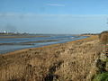
Wyre Estuary Country Park is located in Thornton-Cleveleys, Lancashire, England. Established in 1991 and covering 0.79 acres (0.32 ha), it is situated on the western banks of the 28-mile (45 km) long River Wyre, near its mouth at the Irish Sea at Fleetwood. The Wyre estuary forms part of the southern boundary of Morecambe Bay.

The Royal Oak Hotel was a public house and hotel in the market town of Poulton-le-Fylde, Lancashire. It stood on Breck Road at its junction with Station Road. Built in 1842, it was, up until its demolition, the only hotel in the town. It replaced an earlier building, known as the Old Oak, which had also been a dye works.

The Golden Ball is a public house and hotel on Ball Street in the English market town of Poulton-le-Fylde, Lancashire. Built in the 19th century, it was originally a coaching inn for travellers making their way to local towns and villages. During the course of its existence, the building has been a police courtroom, a newsroom and a café. Ball Street is named for the pub.

Cockle Hall is an historic location in Thornton-Cleveleys, Lancashire, England. Located in today's Wyre Estuary Country Park, it was the location of one of the earliest crossings of the River Wyre, and was used as such until the 1930s. It is also the former site of a two-storey cottage occupied by the Lawrenson family of thirteen. It was located a short distance along today's footpath running from the car park at Wyre Estuary, along the western banks of the river. The ferryman who took people to and brought people from Wardleys Creek, on the eastern side of the river, also lived there.

Victoria Road is a major thoroughfare in Thornton-Cleveleys, Lancashire, England. Originally known as Ramper Road, it runs for about 2 miles (3.2 km) from Station Road in Thornton, in the east, to South Promenade in Cleveleys, in the west. Its addresses are denoted as "Victoria Road East" or "Victoria Road West", the split occurring at the Amounderness Way roundabout carrying traffic of the A585 between Poulton-le-Fylde and Fleetwood. The road picks up the B5412 designation from Station Road until The Crescent and Brighton Avenue in Cleveleys.

Wardleys Creek is an area of Stalmine-with-Staynall, near the village of Hambleton, Lancashire, England. It is located on the eastern banks of the River Wyre, around 4 miles (6.4 km) from the river's mouth at the Irish Sea.


