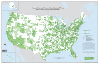
In the United States, a metropolitan statistical area (MSA) is a geographical region with a relatively high population density at its core and close economic ties throughout the region. Such regions are not legally incorporated as a city or town would be and are not legal administrative divisions like counties or separate entities such as states. That makes the precise definition of any given metropolitan area vary with the source. The statistical criteria for a standard metropolitan area were defined in 1949 and redefined as a metropolitan statistical area in 1983.

Peach County is a county located in the central portion of the U.S. state of Georgia. As of the 2020 census, the population was 27,981. Its county seat is Fort Valley. Founded in 1924, it is the state's newest county, taken from Houston and Macon counties on July 18 of that year. Its namesake is the peach on account of it being located in a peach-growing district.

Houston County is a county located in the central portion of the U.S. state of Georgia. The population was 163,633 at the 2020 census. Its county seat is Perry; the city of Warner Robins is substantially larger in both area and population.

Centerville is a city in Houston County, Georgia, United States. The city is a part of the larger Macon-Warner Robins Combined Statistical Area. It was incorporated March 25, 1958. As of the 2010 census, the city had a population of 7,148, up from 4,278 in 2000. The city's central location, proximity to major highways and interstates, and excellent quality of life makes it one of the top bedroom communities in Georgia. In 2016, Centerville was ranked 7th Happiest City in Georgia by zippia.com, a website devoted to career-related rankings.

Perry is a city in Houston and Peach counties in the U.S. state of Georgia. It is the county seat of Houston County. The population was 13,839 at the 2010 census, up from 9,602 at the 2000 census. As of 2019 the estimated population was 17,894. It is part of the Warner Robins, Georgia Metropolitan Statistical Area, within the Macon–Bibb County–Warner Robins Combined Statistical Area.

Warner Robins is a city in Houston and Peach counties in the U.S. state of Georgia. It is currently the state's eleventh-largest incorporated city, with a population of 80,308 in the 2020 Census.

Byron is a city located primarily in Peach County, Georgia, United States. A small portion of the city also extends into parts of Houston and Crawford counties. The population was estimated to be 5,149 in 2019 by the Census Bureau, an increasing of 14.1% from 4,512 at the 2010 census. The city is in the Warner Robins Metropolitan Statistical Area.

Fort Valley is a city in and the county seat of Peach County, Georgia, United States. As of the 2020 census, the city had a population of 8,780.

The Louisville metropolitan area is the 43rd largest metropolitan statistical area (MSA) in the United States. It had a population of 1,395,855 in 2020 according to the latest official census, and its principal city is Louisville, Kentucky.
Pennsylvania has fourteen metropolitan statistical areas (MSAs) and four combined statistical areas (CSAs), as defined by the United States Census Bureau. A map of the Pennsylvania MSAs is available from the Census Bureau. As of 2020 Philadelphia is the seventh-largest United States metropolitan area.

The Harrisburg–Carlisle metropolitan statistical area, officially the Harrisburg–Carlisle, PA Metropolitan Statistical Area, and also referred to as the Susquehanna Valley, is defined by the Office of Management and Budget as an area consisting of three counties in South Central Pennsylvania, anchored by the cities of Harrisburg and Carlisle.

Greater San Antonio, officially designated San Antonio–New Braunfels, is an eight-county metropolitan area in the U.S. state of Texas defined by the Office of Management and Budget (OMB). The metropolitan area straddles South Texas and Central Texas and is on the southwestern corner of the Texas Triangle. The official 2020 U.S. census showed the metropolitan area's population at 2,558,143—up from a reported 1,711,103 in 2000—making it the 24th largest metropolitan area in the United States. Austin–Round Rock lies about 80 mi (130 km) northeast of Greater San Antonio.
The Chattanooga, TN-GA metropolitan statistical area, as defined by the United States Office of Management and Budget, is an area consisting of six counties – three in southeast Tennessee and three in northwest Georgia – anchored by the city of Chattanooga. As of the 2010 census, the MSA had a population of 528,143. This metropolitan area traverses two time zones.
Central Georgia is the area containing the metropolitan region surrounding the city of Macon, in Bibb County in the U.S. state of Georgia. It abuts the Atlanta metropolitan area, just to the north.

The Columbus, Georgia Metropolitan Statistical Area, as defined by the United States Census Bureau and colloquially known as the Chattahoochee Valley, is an area consisting of six counties in Georgia and one county in Alabama, anchored by the city of Columbus. As of the 2010 census, the MSA had a population of 296,506. The Columbus metropolitan area is a component of the Columbus-Auburn-Opelika (GA-AL) Combined Statistical Area, a trading and marketing region. It is split between the Eastern Time Zone, the time zone the Georgia Counties of the metropolitan area are in, and the Central Time Zone, the time zone in Russell County, Alabama is in, thus making it the only metropolitan area in the United States to be split between multiple time zones.

The Evansville metropolitan area is the 164th largest metropolitan statistical area (MSA) in the United States. The primary city is Evansville, Indiana, the third most populous city in Indiana and the most populous city in Southern Indiana as well as the hub for Southwestern Indiana. Other Indiana cities include Boonville, Mount Vernon, Jasper, Oakland City, Princeton, and Vincennes. Large towns in Indiana include Chandler, Fort Branch, McCutchanville, and Newburgh. Cities in Kentucky include Henderson, Dixon, Providence, and Robards and currently covers an area of 2,367 sq mi (6,130 km2). It is the primary metropolitan area in the Illinois–Indiana–Kentucky Tri-State Area.
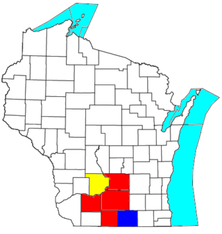
The Madison, Wisconsin, metropolitan area, also known as Greater Madison, is the metropolitan area surrounding the city of Madison, Wisconsin. Madison is the state capital of Wisconsin and is Wisconsin's second largest city, and the metropolitan area is also the state's second largest.

The Augusta metropolitan area is a metropolitan area in the U.S. states of Georgia and South Carolina centered on the principal city of Augusta. The U.S. Office of Management and Budget, Census Bureau and other agencies define Augusta's Metropolitan Statistical Area, the Augusta-Richmond County, GA-SC Metropolitan Statistical Area, as comprising Richmond, Burke, Columbia, Lincoln, and McDuffie counties in Georgia and Aiken and Edgefield counties in South Carolina. The official 2021 U.S. Census estimate for the area was 615,963 residents.
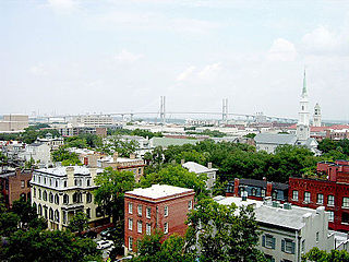
The Savannah metropolitan area is centered on the principal city of Savannah, Georgia. The official name given by the U.S. Office of Management and Budget (OMB) is the Savannah, GA Metropolitan Statistical Area, which is used for statistical purposes by the United States Census Bureau and other entities. The OMB defines this area as consisting of Bryan, Chatham, and Effingham counties in Georgia; its total population was 404,798 in the official 2020 U.S. Census, compared to 347,611 in the 2010 census. Savannah is the third most populous of fourteen Georgia metropolitan areas. It was the fastest-growing metro area in the state for the period 2010–2020.
The Macon metropolitan area is a metropolitan area consisting of five counties in Central Georgia anchored by the principal city of Macon. The Office of Management and Budget defines the area as one of its metropolitan statistical areas, a designation used for statistical purposes by the United States Census Bureau and other agencies.
