Washington meridians

Last updated

The Washington meridians are four meridians that were used as prime meridians in the United States which pass through Washington, D.C. The four that have been specified are:

Contents

  1. through the Capitol
  2. through the White House
  3. through the old Naval Observatory
  4. through the new Naval Observatory.

Their longitudes may be reported in three ways:

  1. relative to the local vertical used by astronomic observations
  2. relative to NAD 27 (North American Datum 1927), an ellipsoid of revolution that is at mean sea level beneath triangulation station Meades Ranch, Kansas (not Earth-centered);
  3. relative to NAD 83, an Earth-centered ellipsoid of revolution with dimensions chosen to best fit the undulating (±100 m) geoid (world-wide mean sea level).

NAD83 longitude of the Capitol is about 1.1 arc seconds less than its NAD27 longitude; astronomic longitude there is about 4 arc seconds less than NAD83.

Capitol meridian

Pierre (Peter) Charles L'Enfant specified the first meridian in his 1791 "Plan of the city intended for the permanent seat of the government of the United States . . ." (see: L'Enfant Plan). [1] [2] [3] (Shortly after L'Enfant prepared this plan, its subject received the name "City of Washington".) His plan stated near its right side that the longitude of the Congress house, now called the Capitol, was 0,0°. [2]

L'Enfant's plan contained the following explanatory note:

In order to execute the above plan, Mr. Ellicott drew a true meridian line by celestial observation, which passes through the area intended for the Congress-House; this line he crossed by another line due east and west and which passes through the same area. These lines were accurately measured, and made the basis on which the whole plan was executed. He ran all the lines by a transit instrument, and determined the acute angles by actual measurement, and left nothing to the uncertainty of the compass. [2]

The longitude of the center of the Capitol's dome (completed in 1863 during the Civil War) is now given by the National Geodetic Survey as 77°00′32.6″W (NAD 83).

White House meridian

West side of Jefferson Pier in April 2011 with Washington Monument in background. Jefferson Pier and Washington Monument.jpg
West side of Jefferson Pier in April 2011 with Washington Monument in background.
Zero Milestone, 1923, looking north toward the White House. Zeropost-1923.jpg
Zero Milestone, 1923, looking north toward the White House.

L'Enfant planned Washington around a right triangle, having its 90° vertex at an equestrian statue of George Washington, its eastern vertex at the "Congress house" and its northern vertex at the President's House, now named the "White House". [4] (This would place L'Enfant's statue 0.36 meters (1 ft 2 in) north of the latitude of the Capitol.)

The west side of L'Enfant's triangle forms a natural prime meridian passing through the center of the President's house. The following ten features on and near this "Washington Meridian" are listed from south to north:

Tablet facing 16th Street, NW, on west wall of Meridian Hill Park in 2006. The tablet states that a Washington Meridian marker stone was formerly located 52 feet 9 inches (16.1 m) west of the tablet. WashingtonMeridianMarker.jpg
Tablet facing 16th Street, NW, on west wall of Meridian Hill Park in 2006. The tablet states that a Washington Meridian marker stone was formerly located 52 feet 9 inches (16.1 m) west of the tablet.
Entrance marker stone near Silver Spring in traffic circle (Blair Circle) in December 2011 DC Boundary Marker at SS traffic circle.jpg
Entrance marker stone near Silver Spring in traffic circle (Blair Circle) in December 2011

Old Naval Observatory meridian

Meridian four blocks north of Old Naval Observatory, looking south in August 2005. The American Meridian Line (38782358).jpg
Meridian four blocks north of Old Naval Observatory, looking south in August 2005.

The third meridian was defined on September 28, 1850, by Congress: "[T]he meridian of the observatory at Washington shall be adopted and used as the American meridian for all astronomical purposes and ... the meridian of Greenwich shall be adopted for all nautical purposes." [16] The observatory decided that this meridian passed through the center of the original (small) dome atop the main building of the Old Naval Observatory, now abandoned southwest of the corner of E and 23rd Streets in Foggy Bottom (north of the Lincoln Memorial and west of the White House). The observatory adopted 77°2′48.0″W for its meridian in the American Ephemeris and Nautical Almanac for the years 1855 to 1869 (as 5h8m11.2s). In 1897, well after the observatory closed in 1892, the Coast and Geodetic Survey reported that its meridian was 77°3′2.3″ west of Greenwich, [17] which was quoted for the next 50 years in the list of observatories in the Almanac (as 5h8m12.15s). When referred to later datums, this meridian has been variously specified as 77°3′6.119″W or 77°3′6.276″W (both presumably NAD 27). If NAD27, the latter would be 77°3′5.194″W (NAD 83) which seems to be within a few meters of the actual longitude, at worst. This meridian was repealed by Congress on August 22, 1912, to allow the Greenwich meridian to become the legal prime meridian of the United States.

Western state borders

Many western states have borders that are meridians of "longitude west of Washington", that is, west of the legal 1850 meridian through the Old Naval Observatory. However, their present boundaries follow the subsequently surveyed boundary, even when inaccurately marked a few miles (kilometers) east or west of the meridian in the statute. Other western states have meridians relative to Greenwich (Alaska, California, Oklahoma, Texas) or relative to a river or lake (Arkansas, Louisiana, Minnesota, Missouri, Oregon, Washington state).

The following meridians west of Washington are listed east to west, along with the appropriate boundary of the present state. The date of the meridian's definition is in parentheses (all in the 1860s). All states were territories of the same name when their meridians were specified except as noted. States without dates have boundaries dependent on the neighboring state with a date listed immediately above it.

Four Corners Monument 32deg west of Washington Meridian, after 2010 reconstruction. Four Corners, NM, reconstructed monument in 2010.jpg
Four Corners Monument 32° west of Washington Meridian, after 2010 reconstruction.
DegreeBoundary
17°SW Arkansas (south of the Red River)
E Texas (between the Red and Sabine Rivers)
NW Louisiana (north of the Sabine River)
25° W Kansas (January 29, 1861) as a state
E Colorado (February 28, 1861), NE not dependent on Kansas
SW Nebraska
26°W Texas (between 32° N and 36°30′ N)
E New Mexico (between 32° N and 36°30′ N)
27° E Montana (March 3, 1863) as Idaho Territory
E Wyoming (March 3, 1863) as Idaho Territory
NW Nebraska
W North Dakota as Dakota Territory
W South Dakota as Dakota Territory
32° W Colorado (February 28, 1861)
SE Utah
E Arizona (February 24, 1863)
W New Mexico
34° SW Montana (May 26, 1864)
W Wyoming (July 25, 1868), SW not dependent on Montana
SE Idaho
NE Utah
37° E Nevada (May 5, 1866) as a state (39° → 38° → 37°)
W Utah
39° NW Montana (May 26, 1864)
NE Idaho
43° W Nevada (1864) [19]

New Naval Observatory meridian

The fourth meridian was through the clock room of the new Naval Observatory, 2.3 mi (3.7 km) northwest of the White House, at 77°3′56.7″W (1897) or 77°4′2.24″W (NAD 27) or 77°4′1.16″W (NAD 83). The clock room is a small building at the exact center of the 1,000 ft (300 m) radius observatory grounds, whose northern entrance is at 34th Street and Massachusetts Avenue. It was used in the Almanac for the years 1898–1950 as the independent variable of time for a few tables (even though Washington's civil time since 1883 had been that of the standard time zone GMT−5 hours (75°W)).

See also

Notes

  1. (1) Pierre Charles L'Enfant's 1791 "Plan of the city intended for the permanent seat of the government ...." in official website of the U.S. Library of Congress. Retrieved 2008-08-13.
  2. 1 2 3 L'Enfant, Peter Charles (1791). "Plan of the city intended for the permanent seat of the government of t(he) United States : projected agreeable to the direction of the President of the United States, in pursuance of an act of Congress passed the sixteenth day of July, MDCCXC, "establishing the permanent seat on the bank of the Potowmac": (Washington, D.C.)". Photocopy of annotated facsimile created by U.S. Coast and Geodetic Survey, Washington, D.C. (1887). Library of Congress . Retrieved 2016-01-26.
  3. (1) Freedom Plaza in Northwest Washington contains an inlay of L'Enfant's Plan with a legend identifying the longitude of the Congress house as 0,0°.
    (2) L'Enfant identified himself as "Peter Charles L'Enfant" during most of his life, while residing in the United States. He wrote this name on his "Plan of the city intended for the permanent seat of the government of t(he) United States ...." (Washington, D.C.) and on other legal documents. However, during the early 1900s, a French ambassador to the U.S., Jean Jules Jusserand, poipularized the use of L'Enfant's birth name, "Pierre Charles L'Enfant". (See: Bowling, Kenneth R (2002). Peter Charles L'Enfant: vision, honor, and male friendship in the early American Republic. George Washington University, Washington, D.C.) The National Park Service identifies L'Enfant as "Major Peter Charles L'Enfant" and as "Major Pierre (Peter) Charles L'Enfant" on its website. The United States Code states in 40 U.S.C.   § 3309: "(a) In General.The purposes of this chapter shall be carried out in the District of Columbia as nearly as may be practicable in harmony with the plan of Peter Charles L'Enfant."
  4. "Map 1: The L'Enfant Plan for Washington". National Park Service. Archived from the original on January 21, 2009. Retrieved 2009-10-27.
  5. Coordinates of center of Jefferson Memorial: 38°52′53″N77°02′12″W / 38.881379°N 77.036546°W
  6. Coordinates of Jefferson Pier: 38°53′23″N77°02′12″W / 38.889812°N 77.036558°W
  7. Coordinates of German-American Friendship Garden: 38°53′31″N77°02′12″W / 38.89187°N 77.036550°W
  8. Coordinates of Meridian Stone: 38°53′38″N77°02′12″W / 38.893943°N 77.036548°W
  9. Coordinates of Zero Milestone: 38°53′42″N77°02′12″W / 38.895117°N 77.036561°W
  10. Coordinates of center of the White House: 38°53′52″N77°02′12″W / 38.897680°N 77.036558°W
  11. Coordinates of equestrian statue of Andrew Jackson in Lafayette Park: 38°53′58″N77°02′12″W / 38.899523°N 77.036553°W
  12. Coordinates of south end of 16th Street NW: 38°54′01″N77°02′12″W / 38.900293°N 77.036543°W
  13. "Sixteenth Street, Washington, District of Columbia, DC". Historic American Buildings Survey (HABS), Engineering Record, Landscapes Survey. p. 5. HABS DC-717. Archived from the original on January 27, 2016.
  14. Coordinates of District of Columbia entrance marker stone near Silver Spring in traffic circle at intersection of 16th Street Northwest, Eastern Avenue Northwest, N. Portal Drive Northwest and Colesville Road: 38°59′32″N77°02′11″W / 38.992322°N 77.036326°W
  15. Coordinates of "The American Meridian" line in sidewalk of H Street NW at 24th Street NW, in southeast corner of intersection: 38°53′58″N77°03′05″W / 38.8995°N 77.051315°W
  16. 9Statutes at Large 515
  17. 3618Serial Set 254
  18. Coordinates of Four Corners Monument: 36°59′56″N109°02′43″W / 36.998976°N 109.045172°W , 1,807 feet (551 m) east of 32°W at 31.9938°W.
  19. California v. Nevada, 44U.S.125 ( Supreme Court of the United States 1980)("Nevada's Constitution stated that its boundary would proceed "in a North Westerly direction along [the oblique section of the] Eastern boundary line of the State of California to the forty third degree of Longitude West from Washington [and then] North along said forty third degree of West Longitude, and said Eastern boundary line of the State of California to the forty second degree of North Latitude. ..." Nev.Const., Art. XIV, § 1 (1864). Although it turns out that the 43d degree of longitude west from Washington does not exactly coincide with the 120th meridian west of Greenwich—which was the north-south reference in the California Constitution").

Related Research Articles

<span class="mw-page-title-main">Prime meridian</span> Line of longitude, at which longitude is defined to be 0°

A prime meridian is an arbitrary meridian in a geographic coordinate system at which longitude is defined to be 0°. Together, a prime meridian and its anti-meridian form a great circle. This great circle divides a spheroid, like Earth, into two hemispheres: the Eastern Hemisphere and the Western Hemisphere. For Earth's prime meridian, various conventions have been used or advocated in different regions throughout history. Earth's current international standard prime meridian is the IERS Reference Meridian. It is derived, but differs slightly, from the Greenwich Meridian, the previous standard.

<span class="mw-page-title-main">National Mall</span> United States historic place

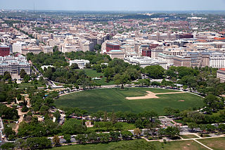
The National Mall is a landscaped park near the downtown area of Washington, D.C., the capital city of the United States. It contains and borders a number of museums of the Smithsonian Institution, art galleries, cultural institutions, and various memorials, sculptures, and statues. It is administered by the National Park Service (NPS) of the United States Department of the Interior as part of the National Mall and Memorial Parks unit of the National Park System. The park receives approximately 24 million visitors each year.

<span class="mw-page-title-main">Pierre Charles L'Enfant</span> French-American architect (1754–1825)

Pierre "Peter" Charles L'Enfant was an American-French military engineer who in 1791 designed the basic plan for Washington, D.C., the capital city of the United States. His work is known today as the L'Enfant Plan. He also inspired the street plan for Detroit, Michigan.

<span class="mw-page-title-main">McPherson Square station</span> Washington Metro station

McPherson Square station is a Washington Metro station in Downtown, Washington, D.C., United States. The side-platformed station is operated by the Washington Metropolitan Area Transit Authority (WMATA). Providing service for the Blue, Orange, and Silver Lines, the station is located between McPherson Square and Franklin Square, with two entrances on I Street at Vermont Avenue and 14th Street NW. This is the main station to access the White House, and the Vermont Avenue exit is directly underneath the Department of Veterans Affairs building.

<span class="mw-page-title-main">Smithsonian station</span> Washington Metro station

Smithsonian station is a Washington Metro station at the National Mall in Washington, D.C., United States. The side platformed station was opened on July 1, 1977, and is operated by the Washington Metropolitan Area Transit Authority (WMATA). It is a stop on the Blue, Orange and Silver Lines. The station's south entrance is at the southwest corner of Independence Avenue and 12th Street, Southwest, the street elevator is at the northwest corner of the same intersection, and the north entrance is on the south side of the Mall near Jefferson Drive, Southwest.

<span class="mw-page-title-main">Zero Milestone</span>

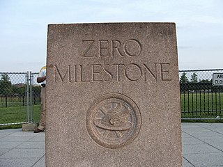
The Zero Milestone is a zero mile marker monument in Washington, D.C., intended as the initial milestone from which all road distances in the United States should be measured when it was built. At present, only roads in the Washington, D.C., area have distances measured from it.

<span class="mw-page-title-main">History of Washington, D.C.</span> History of the US capital

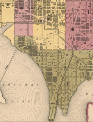
The history of Washington, D.C., is tied to its role as the capital of the United States. The site of the District of Columbia along the Potomac River was first selected by President George Washington. The city came under attack during the War of 1812 in an episode known as the Burning of Washington. Upon the government's return to the capital, it had to manage the reconstruction of numerous public buildings, including the White House and the United States Capitol. The McMillan Plan of 1901 helped restore and beautify the downtown core area, including establishing the National Mall, along with numerous monuments and museums.

<span class="mw-page-title-main">Massachusetts Avenue (Washington, D.C.)</span> Major road in Washington, D.C., U.S.

Massachusetts Avenue is a major diagonal transverse road in Washington, D.C., and the Massachusetts Avenue Historic District is a historic district that includes part of it.

<span class="mw-page-title-main">16th Street NW</span> Road in Washington, D.C.

16th Street Northwest, briefly known as the Avenue of the Presidents, is a prominent north-south boulevard in Washington, D.C., located in Northwest D.C. The street was laid out as part of the 1791 L'Enfant Plan, which served as the original blueprint for the city. The street begins just north of the White House, across from Lafayette Square in the President's Park, and continues north along the Washington meridian until Blair Circle.

<span class="mw-page-title-main">Freedom Plaza</span> Open plaza in Washington, D.C.

Freedom Plaza, originally known as Western Plaza, is an open plaza in Northwest Washington, D.C., United States, located near 14th Street and Pennsylvania Avenue NW, adjacent to Pershing Park. The plaza features an inlay that partially depicts Pierre (Peter) Charles L'Enfant's plan for the City of Washington. The National Park Service administers the Plaza as part of its Pennsylvania Avenue National Historic Site and coordinates the Plaza's activities.

<span class="mw-page-title-main">Andrew Ellicott</span> American surveyor

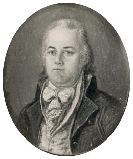
Andrew Ellicott was an American land surveyor who helped map many of the territories west of the Appalachians, surveyed the boundaries of the District of Columbia, continued and completed Pierre (Peter) Charles L'Enfant's work on the plan for Washington, D.C., and served as a teacher in survey methods for Meriwether Lewis.

<span class="mw-page-title-main">The Ellipse</span> Park in Washington, D.C., U.S.

The Ellipse, sometimes referred to as President's Park South, is a 52-acre (21 ha) park south of the White House fence and north of Constitution Avenue and the National Mall in Washington, D.C., US. The Ellipse is also the name of the five-furlong (1.0 km) circumference street within the park. The entire park, which features monuments, is open to the public and is part of President's Park. The Ellipse is the location for many annual events.

<span class="mw-page-title-main">Scott Circle</span>

Scott Circle is an area in the northwest quadrant of Washington, D.C. that is centred on the junction of Massachusetts Avenue, Rhode Island Avenue, and 16th Street, N.W. Originally a neighborhood recreational area like nearby Dupont Circle, Scott has lost all social uses except as the location for public memorials.

<span class="mw-page-title-main">Jefferson Pier</span>

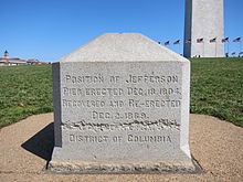
Jefferson Pier, Jefferson Stone, or the Jefferson Pier Stone, in Washington, D.C., marks the second prime meridian of the United States even though it was never officially recognized, either by presidential proclamation or by a resolution or act of Congress.

<span class="mw-page-title-main">Tiber Creek</span> River in District of Columbia, U.S.

Tiber Creek or Tyber Creek, originally named Goose Creek, is a tributary of the Potomac River in Washington, D.C. It was a free-flowing creek until 1815, when it was channeled to become part of the Washington City Canal. Presently, it flows under the city in tunnels, including under Constitution Avenue NW.

<span class="mw-page-title-main">Washington City Canal</span>

The Washington City Canal operated from 1815 until the mid-1850s in Washington, D.C. The canal connected the Anacostia River, termed the "Eastern Branch" at that time, to Tiber Creek, the Potomac River, and later the Chesapeake and Ohio (C&O) Canal. The canal became disused during the late 19th century and the city government covered over or filled in various sections in 1871.

<span class="mw-page-title-main">Boundary markers of the original District of Columbia</span> Markers that marked the District of Columbias original boundary

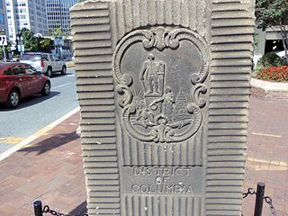
The boundary markers of the original District of Columbia are the 40 milestones that marked the four lines forming the boundaries between the states of Maryland and Virginia and the square of 100 square miles (259 km2) of federal territory that became the District of Columbia in 1801. Working under the supervision of three commissioners that President George Washington had appointed in 1790 in accordance with the federal Residence Act, a surveying team led by Major Andrew Ellicott placed these markers in 1791 and 1792. Among Ellicott's assistants were his brothers Joseph and Benjamin Ellicott, Isaac Roberdeau, George Fenwick, Isaac Briggs and an African American astronomer, Benjamin Banneker.

<span class="mw-page-title-main">German-American Friendship Garden</span>

The German-American Friendship Garden on the National Mall in Washington, D.C. stands as a symbol of the positive and cooperative relations between the United States of America and the Federal Republic of Germany.

<span class="mw-page-title-main">L'Enfant Plan</span> United States historic place; street and land use plan for Washington, DC

The L'Enfant Plan for the city of Washington is the urban plan developed in 1791 by Major Pierre Charles L'Enfant for George Washington, the first president of the United States.

<span class="mw-page-title-main">Garden Club of America Entrance Markers in Washington, D.C.</span> United States historic place

The Garden Club of America Entrance Markers in Washington, D.C., are carven stone pylons installed along the border of the District of Columbia in 1932 and 1933 by local Garden Club of America chapters. Originally about five feet tall, the markers were placed at important entrance points to the national capital. Seven survive: sets of two markers in Westmoreland Circle, Friendship Heights, and Chevy Chase Circle; and a single marker along Georgia Avenue. These surviving markers are listed on the National Register of Historic Places.

References

Map all coordinatesin "Washington meridian" using: OpenStreetMap

38°53′42″N77°03′05″W / 38.895103°N 77.0514428°W / 38.895103; -77.0514428 (Old Naval Observatory)