The Shire of Serpentine-Jarrahdale is a local government area in the outer southeastern metropolitan area of Perth, the capital of Western Australia. The shire has an area of 905 square kilometres (349 sq mi) and a population of 32,173 as at the 2021 census. Despite being named after two towns in the area, neither Serpentine nor Jarrahdale function as either the Shire's largest settlement (Byford) or the seat of government (Mundijong).
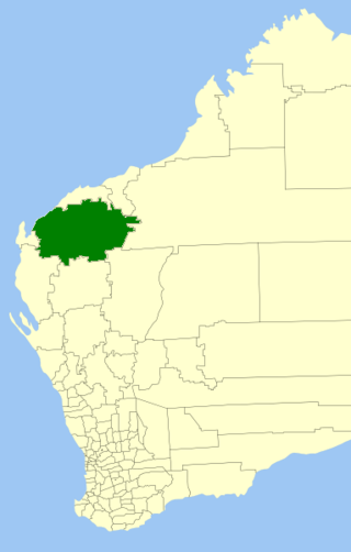
The Shire of Ashburton is one of the four local government areas in the Pilbara region of Western Australia, covering an area of 105,647 square kilometres (40,791 sq mi). It is named after the Ashburton River.

Birchip is a town in the Mallee region of Victoria, Australia on the Sunraysia Highway north of Donald. The town is located in the Shire of Buloke local government area. At the 2021 census, Birchip had a population of 694, down from the 2016 figure of 702. It has a P-12 school, and an Australian rules football club called Birchip-Watchem, also known as the Birchip-Watchem Bulls, or just the "Bulls".

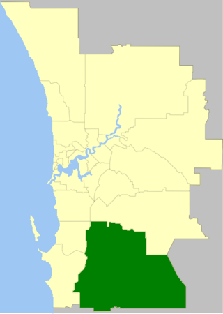
The Shire of West Arthur is a local government area in the Wheatbelt region of Western Australia, generally to the west of Albany Highway about 200 kilometres (124 mi) south-east of Perth, the state capital. The Shire covers an area of 2,834 square kilometres (1,094 sq mi) and its seat of government is the town of Darkan. Industries within the Shire, worth approximately $45 million per year to the State's economy, are dominated by wool and sheep, and also include timber, grain, forestry, beef, pigs, cattle hide tanning, engineering and earthmoving.

The Shire of Derby–West Kimberley is one of four local government areas in the Kimberley region of northern Western Australia, covering an area of 104,080 square kilometres (40,186 sq mi), most of which is sparsely populated. The Shire's population as at the 2016 Census was almost 8,000, with most residing in the major towns of Derby, which is also the Shire's seat of government, and Fitzroy Crossing. There are also around 70 Aboriginal communities within the Shire.

The Shire of East Pilbara is one of the four local government areas in the Pilbara region of Western Australia. With an area of 372,571 square kilometres (143,850 sq mi), larger than the Australian states of Victoria and Tasmania combined, it is the largest local government region in Australia. The Shire's seat of government, and home to nearly half the Shire's population, is the town of Newman in the shire's south-west.

The Shire of Coolgardie is a local government area in the Goldfields–Esperance region of Western Australia, lying roughly west and south of the city of Kalgoorlie. The Shire covers an area of 30,400 square kilometres (11,738 sq mi), and its seat of government is the town of Coolgardie, although the twin towns of Kambalda East and Kambalda West contain two-thirds of the Shire's population.

The Shire of Cuballing is a local government area in the Wheatbelt region of Western Australia. Cuballing is located 15.1 kilometres (9 mi) north of the town of Narrogin and 192 kilometres (119 mi) southeast of the capital, Perth. The Shire covers an area of 1,195 square kilometres (461 sq mi) and its seat of government is the small town of Cuballing.

The Shire of Kulin is a local government area in the eastern Wheatbelt region of Western Australia, about 300 kilometres (186 mi) ESE of the state capital, Perth. The Shire's land area of 4,714 square kilometres (1,820 sq mi) forms a narrow east-west band, located between the Shire of Kondinin to the north and the Shire of Lake Grace to the south. Its seat of government is the town of Kulin. The local economy is based on agriculture - predominantly cereal grains and sheep.

The Shire of Broome is one of the four local government areas in the Kimberley region of northern Western Australia, covering an area of 55,796 square kilometres (21,543 sq mi), most of which is sparsely populated. The Shire's estimated population as at the 2016 census was 16,222 most of whom reside in the town of Broome. Many Aboriginal communities are within the Shire, notably Beagle Bay and Bardi.

The Shire of Westonia is a local government area in the eastern Wheatbelt region of Western Australia, about 310 kilometres (193 mi) east of Perth, the state capital. Its seat of government is the small town of Westonia.

The Shire of Kondinin is a local government area in the eastern Wheatbelt region of Western Australia, about 300 kilometres (186 mi) east of the state capital, Perth. The Shire's land area of 7,376 square kilometres (2,848 sq mi) forms a narrow east-west band, located between the Shire of Narembeen to the north and the Shire of Kulin to the south. Its seat of government is the town of Kondinin.
The Shire of Toodyay is a local government area in the Wheatbelt region of Western Australia, beyond the north-eastern limits of the Perth metropolitan area. The Shire covers an area of 1,694 square kilometres (654 sq mi), and its seat of government is the town of Toodyay.

The Shire of Mornington is a local government area in northwestern Queensland, Australia. The shire covers the Wellesley Islands, which includes Mornington Island; the South Wellesley Islands; Bountiful Islands; and West Wellesley / Forsyth Islands groups in the Gulf of Carpentaria.

The Shire of Mingenew is a local government area in the Mid West region of Western Australia, about 110 kilometres (68 mi) southeast of the city of Geraldton and about 370 kilometres (230 mi) north of the state capital, Perth. The Shire covers an area of 1,939 square kilometres (749 sq mi), and its seat of government is the town of Mingenew.
The Shire of Morawa is a local government area in the Mid West region of Western Australia, about 170 kilometres (106 mi) east-southeast of the city of Geraldton and about 390 kilometres (242 mi) north of the state capital, Perth. The Shire covers an area of 3,516 square kilometres (1,358 sq mi), and its seat of government is the town of Morawa.

The Shire of Northampton is a local government area in the Mid West region of Western Australia, about 50 kilometres (30 mi) north of Geraldton and about 460 kilometres (290 mi) north of the state capital, Perth. The Shire covers an area of 13,738 square kilometres (5,304 sq mi), and its seat of government is the town of Northampton, with the largest settlement being Kalbarri.

The Shire of Perenjori is a local government area in the Mid West region of Western Australia, about 360 kilometres (224 mi) north of the state capital, Perth. The Shire covers an area of 8,313 square kilometres (3,210 sq mi), and its seat of government is the town of Perenjori.

The Shire of Three Springs is a local government area in the Mid West region of Western Australia, about 310 kilometres (193 mi) north of the state capital Perth. The Shire covers an area of 2,657 square kilometres (1,026 sq mi), and its seat of government is the town of Three Springs.

The Shire of Donald was a local government area about 140 kilometres (87 mi) west-northwest of Bendigo, in western Victoria, Australia. The shire covered an area of 1,448 square kilometres (559.1 sq mi), and existed from 1861 until 1995.

