Bang Rak is one of the fifty districts (khet) of Bangkok, Thailand. It lies on the eastern bank of the Chao Phraya River, beyond Khlong Phadung Krung Kasem, which marked the old city boundary. Originating from riverside settlements dating from before the city's foundation, Bang Rak grew inland as new roads and canals were constructed through the area during the second half of the nineteenth century and the early twentieth, attracting communities of expatriates and developing into a major commercial district.

Phra Nakhon is one of the 50 districts (khet) of Bangkok, Thailand. It is the central district of Bangkok, including Rattanakosin Island. Neighboring districts are, from the north, clockwise: Dusit, Pom Prap Sattru Phai, Samphanthawong, and across the Chao Phraya River, Thon Buri, Bangkok Yai, Bangkok Noi, and Bang Phlat.

Pathum Wan is one of the fifty districts (khet) of Bangkok, Thailand. It lies just beyond the old city boundary of Khlong Phadung Krung Kasem, and was a rural area on the eastern outskirts of the city when royal villas were built there in the late nineteenth century. The district was officially established in 1915, and covers an area of 8.37 square kilometres (3.23 sq mi). A large part of the district area is taken up by the campus of Chulalongkorn University and the green expanses of Lumphini Park and the Royal Bangkok Sports Club. By the turn of the 20th–21st centuries, the district had become known as the modern-day city centre, home to the prominent shopping areas of Siam and Ratchaprasong.

Pom Prap Sattru Phai is one of the 50 districts (khet) of Bangkok, Thailand. Neighbouring districts are Dusit, Pathum Wan, Bang Rak, Samphanthawong, and Phra Nakhon. With more than 24,000 inhabitants per square kilometre it is the district with the highest population density in Thailand.

Bangkok Yai is one of the 50 districts (khet) of Bangkok, Thailand. Neighbouring districts are Bangkok Noi, Phra Nakhon, Thon Buri, Phasi Charoen, and Taling Chan.

Phasi Charoen is one of the 50 districts (Khet) of Bangkok, Thailand. The district is bounded by other Bangkok districts : Taling Chan, Bangkok Noi, Bangkok Yai, Thon Buri, Chom Thong, Bang Bon, and Bang Khae.

Nong Khaem is one of the 50 districts (khet) of Bangkok, Thailand. The district is bounded by other Bangkok districts : Thawi Watthana, Bang Khae, Bang Bon of Bangkok, Krathum Baen of Samut Sakhon province, Sam Phran and Phutthamonthon of Nakhon Pathom province. Nong Khaem is Bangkok's westernmost district.
A boat service is regularly scheduled transport using one or more boats, typically on a river, at a set charge, normally depending on the length of the trip and the type of passenger. The service may only be available for foot passengers.

Khlong Phasi Charoen is a canal west of the Chao Phraya River in the Thonburi area of the Bangkok conurbation. The canal links the Tha Chin River to Khlong Bangkok Yai. It starts at Khlong Bangkok Yai near Wat Paknam Bhasicharoen, Bangkok and ends south of Wat Ang Thong, Tambon Don Kai Di, Krathum Baen District, Samut Sakhon Province. It is approximately 24 km (14.9 mi) long.
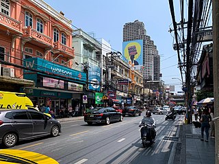
Charoen Krung Road is a major road in Bangkok and the first in Thailand to be built using modern construction methods. Built during 1862–1864 in the reign of King Mongkut, it runs from the old city centre in Rattanakosin Island, passes through Bangkok's Chinatown, continues into Bang Rak district, where it formerly served the community of European expatriates, and ends in Bang Kho Laem. Construction of the road marked a major change in Bangkok's urban development, with the major mode of transport shifting from water to land. Charoen Krung Road was Bangkok's main street up to the early 20th century, but later declined in prominence. It is still home to many historic buildings and neighbourhoods, which are beset by changes as extension of the underground MRT is poised to drive new development.

Sathon Road is a major road that passes through the districts of Bang Rak and Sathon in central Bangkok, Thailand. It is an important transportation link between Phra Nakhon and Thonburi sides of Bangkok.

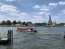
Bangkok has 9.7 million automobiles and motorbikes, a number the government says is eight times more than can be properly accommodated on existing roads. And those numbers are increasing by 700 additional cars and 400 motorbikes every day. Charoen Krung Road, the first road to be built by Western techniques, was completed in 1864. Since then, the road network has expanded to accommodate the sprawling city's needs. Besides roads, Bangkok is served by several other transport systems. Bangkok's canals and ferries historically served as a major mode of transport, but they have long since been eclipsed by land traffic. A complex elevated expressway network and Tollway helps bring traffic into and out of the city centre, but Bangkok's rapid growth has put a large strain on infrastructure. By the late-1970s, Bangkok became known as "the city of traffic disaster". Although rail transport was introduced in 1893 and electric trams served the city from 1894 to 1968, it was only in 1999 that Bangkok's first rapid transit system began operation. Older public transport systems include an extensive bus network and boat services which still operate on the Chao Phraya and two canals. Taxis appear in the form of cars, motorcycles, and tuk-tuks.

Rama IV Road is a main road in Bangkok, Thailand. It starts at Mo Mi Junction in the area of Bangkok's Chinatown in Samphanthawong and Pom Prap Sattru Phai Districts and ends at the junction with Sukhumvit Road in Khlong Toei District near Bangkok Port, also known as Khlong Toei Port.

Khlong Phadung Krung Kasem is a canal (khlong) in Bangkok. It was dug in 1851 in order to serve as a new outer moat for the expanding city, extending its boundaries from the Rattanakosin Island to the north and east.
Bobae Market, usually shortened to Bobae, is a well-known cheap clothing market, both retail and wholesale. The market area has two huge wholesale shopping areas, Bobae Market and Bobae Tower.

Si Yaek Maha Nak is a sub-district (khwaeng) of Dusit district, Bangkok.

Wat Tha Phra is one of the two khwaeng (subdistrict) of Bangkok Yai District, Bangkok's Thonburi side.

Thewet Naruemit Bridge is a historic bridge over canal Khlong Phadung Krung Kasem in Bangkok, Thailand. Its name is also the name of the surrounding area known as Thewet. The bridge straddles between four sub-districts of two administrative districts of Bangkok, namely Wat Sam Phraya and Bang Khun Phrom Subdistricts, Phra Nakhon District with Wachiraphayaban and Dusit Subdistricts, Dusit District.

The manufacture, sale, and adoption of electric vehicles in Thailand is supported by the Thai government, in order to reduce carbon emissions and air pollution. Prime Minister Prayut Chan-o-cha appointed the National Electric Vehicle Policy Committee in February 2020 to set targets for zero emission vehicle adoption. The government has announced aims for 30% of automobiles produced in 2030 to be electric, and to become a regional hub for electric vehicle manufacturing.