
Cape Jervis is a town in the Australian state of South Australia located near the western tip of Fleurieu Peninsula on the southern end of the Main South Road approximately 88 kilometres (55 mi) south of the state capital of Adelaide.
Middleton is a town in South Australia on the eastern end of the south coast of the Fleurieu Peninsula. It is found between the towns of Port Elliot and Goolwa.
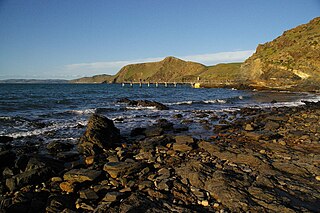
Second Valley is a coastal town on the Fleurieu Peninsula in South Australia.

Aldinga Beach is an outer southern suburb of Adelaide, South Australia. It lies within the City of Onkaparinga and has the postcode 5173. At the 2011 census, Aldinga Beach had a population of 9,697. The beach is a well-known spot for surfing, swimming, scuba diving, and snorkeling during the summer months. It overlooks an aquatic reserve which has been created to safeguard a unique reef formation.

Sellicks Hill is a semi-rural suburb of Adelaide, South Australia. It lies within both the City of Onkaparinga and the District Council of Yankalilla.

Delamere is a locality in the Australian state of South Australia located on the south coast of the Fleurieu Peninsula about 80 kilometres (50 mi) south of the state capital of Adelaide and about 18 kilometres (11 mi) south-west of the municipal seat of Yankalilla. It includes what was once a neighbouring village of Bullaparinga.

Myponga is a settlement in South Australia. At the 2016 census, the locality had a population of 744 of which 393 lived in its town centre. Myponga is located within the federal division of Mayo, the state electoral district of Mawson, and the local government area of the District Council of Yankalilla.
Nepean Bay is a locality in the Australian state of South Australia located on the southern shore of Western Cove in Nepean Bay on the north coast of Kangaroo Island and about 128 kilometres south-west of the state capital of Adelaide and about 10 kilometres south-south-west of the municipal seat of Kingscote.
Sultana Point is a locality in the Australian state of South Australia located on the Yorke Peninsula immediately adjoining the western head of Gulf St Vincent about 80 kilometres west of the state capital of Adelaide.
American Beach is a locality in South Australia on the north coast of Dudley Peninsula on Kangaroo Island overlooking Nepean Bay, about 115 kilometres south-west of Adelaide.
Porky Flat is a locality in the Australian state of South Australia located on the Dudley Peninsula on Kangaroo Island overlooking the body of water known in Australia as the Southern Ocean and by international authorities as the Great Australian Bight. It is located about 116 kilometres south of the state capital of Adelaide and about 18 kilometres south-west of Penneshaw.
Cassini is a locality in the Australian state of South Australia located on the north coast of Kangaroo Island overlooking Investigator Strait about 138 kilometres south-west of the state capital of Adelaide and about 31 kilometres from the municipal seat of Kingscote.

Myponga Beach is a locality in the Australian state of South Australia located on the west coast of the Fleurieu Peninsula overlooking Gulf St Vincent about 54 kilometres south of the state capital of Adelaide.
Duncan is a locality in the Australian state of South Australia located on Kangaroo Island about 162 kilometres south-west of the state capital of Adelaide and about 49 kilometres west of the municipal seat of Kingscote.
Bray is a locality in South Australia. It is roughly contiguous with the land administration division, the Hundred of Bray, after which it was named.
Clay Wells is a locality in the Australian state of South Australia located in the state's south-east within the Limestone Coast region about 300 kilometres (190 mi) south east of the state capital of Adelaide, and about 39 kilometres (24 mi) south-east and about 35 kilometres (22 mi) north-west respectively of the municipal seats of Robe and Millicent.
Wattle Range is a locality in the Australian state of South Australia located in the state’s south-east about 328 kilometres (204 mi) south-east of the state capital of Adelaide and about 25 kilometres (16 mi) north-east of the municipal seat in Millicent.
Chiton is a locality in the Australian state of South Australia located on the south coast of Fleurieu Peninsula about 67 kilometres (42 mi) south of the state capital of Adelaide and about 11 kilometres (6.8 mi) west of the municipal seat of Goolwa.
Hindmarsh Tiers is a locality in the Australian state of South Australia located about 55 kilometres (34 mi) south of the state capital of Adelaide and about 15 kilometres (9.3 mi) north of the municipal seat of Victor Harbor.
Parawa is a locality in the Australian state of South Australia located about 74 kilometres (46 mi) south of the state capital of Adelaide and about 11 kilometres (6.8 mi) south of the municipal seat in Yankalilla.

