West India Quay

Last updated

West India Quay
West India Quay - geograph.org.uk - 1473453.jpg
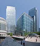
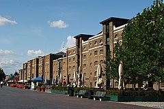
The front of West India Quay
Greater London UK location map 2.svg
Red pog.svg
West India Quay
Location within Greater London
OS grid reference TQ375802
London borough
Ceremonial county Greater London
Region
Country England
Sovereign state United Kingdom
Post town LONDON
Postcode district E14
Police Metropolitan
Fire London
Ambulance London
UK Parliament
London Assembly
List of places
UK
England
London
51°30′24″N0°1′20″W / 51.50667°N 0.02222°W / 51.50667; -0.02222 Coordinates: 51°30′24″N0°1′20″W / 51.50667°N 0.02222°W / 51.50667; -0.02222

West India Quay is an area in the London Docklands, London, England. It is immediately to the north of the West India Docks and Canary Wharf. The warehouse at West India Quay was used to store imported goods from the West Indies, such as tea, sugar and rum, and is now a Grade I listed building. [1]

Contents

Amenities

West India Quay West India Quay - May 2009.jpg
West India Quay

Museum of London Docklands is in West India Quay, inside one of the two remaining traditional brick warehouses in the West India Docks, as is 1 West India Quay. The West India Quay DLR station serves the area.

There is a Cineworld cinema, a Marriott hotel and several restaurants facing the water.

Transport

The north dock of the West India Docks adjacent to the district has been partially drained as part of the construction of Crossrail and new station is being built at the dock (linking to the West India Quay DLR station). [2] The SS Robin and the Steam Tug Portwey have been moved away from the dock as a result of the works.

On 22 April 1991, two Docklands Light Railway trains collided at a junction on the West India Quay bridge during morning rush hour, requiring a shutdown of the entire system and evacuation of the involved passengers by ladder. [3] [4] One of the two trains was travelling automatically, operating without a driver, while the other was under manual control. [5]

Notes

  1. Grade I Building reference (Tower Hamlets) LB644(a), Warehouses and General Offices, West India Dock Road, at western end of North Quay, retrieved from http://webgis.towerhamlets.gov.uk/ 2009-12-24
  2. Work officially starts on Crossrail - Photos Archived 17 May 2009 at the Wayback Machine , ContractJournal.com, accessed 2009-05-17
  3. Another commuter train wreck in London, Jonathan I. Kamens, RISKS Digest Volume 11 Issue 52 Article 1, 23 April 1991
  4. Computer-controlled commuter trains collide in east London, UPI report relayed by ClariNet news service, 22 April 1991
  5. Re: Trains collide in east London, Ian G Batten, RISKS Digest Volume 11 Issue 54 Article 10, 25 April 1991

Related Research Articles

<span class="mw-page-title-main">Docklands Light Railway</span> Automated light metro system in the Docklands area of London, England

The Docklands Light Railway (DLR) is an automated light metro system serving the redeveloped Docklands area of London, England and provides a direct connection between London's two major financial districts, Canary Wharf and the City of London. First opened on 31 August 1987, the DLR has been extended multiple times, giving a total route length of 38 km. Lines now reach north to Stratford, south to Lewisham, west to Tower Gateway and Bank in the City of London financial district, and east to Beckton, London City Airport and Woolwich Arsenal. Further extensions are being considered.

<span class="mw-page-title-main">London Docklands</span> Area in east and southeast London, UK

London Docklands is the riverfront and former docks in London. It is located in inner east and southeast London, in the boroughs of Southwark, Tower Hamlets, Lewisham, Newham, and Greenwich. The docks were formerly part of the Port of London, at one time the world's largest port. After the docks closed, the area had become derelict and poverty-ridden by the 1980s. The Docklands' regeneration began later that decade; it has been redeveloped principally for commercial and residential use. The name "London Docklands" was used for the first time in a government report on redevelopment plans in 1971 and has since been almost universally adopted. The redevelopment created wealth, but also led to some conflict between the new and old communities in the area.

<span class="mw-page-title-main">Isle of Dogs</span> Area in the East End of London, England

The Isle of Dogs is a large peninsula bounded on three sides by a large meander in the River Thames in East London, England, which includes the Cubitt Town, Millwall and Canary Wharf districts. The area was historically part of the Manor, Hamlet, Parish and, for a time, the wider borough of Poplar. The name had no official status until the 1987 creation of the Isle of Dogs Neighbourhood by Tower Hamlets London Borough Council. It has been known locally as simply "the Island" since the 19th century.

<span class="mw-page-title-main">Limehouse</span> District in Tower Hamlets, London

Limehouse is a district in the London Borough of Tower Hamlets in East London. It is 3.9 miles (6.3 km) east of Charing Cross, on the northern bank of the River Thames. Its proximity to the river has given it a strong maritime character, which it retains through its riverside public houses and steps, such as The Grapes and Limehouse Stairs. It is part of the traditional county of Middlesex. It became part of the ceremonial County of London following the passing of the Local Government Act 1888, and then part of Greater London in 1965. It is located between Stepney to the west and north, Mile End and Bow to the northwest, Poplar to the east, and Canary Wharf and Millwall to the south, and stretches from the end of Cable Street and Butcher Row in the west to Stainsby Road near Bartlett Park in the east, and from West India Dock and the River Thames in the south to Salmon Lane and Rhodeswell Road in the north.

<span class="mw-page-title-main">Poplar, London</span> Area of East London, England

Poplar is a district in East London, England, the administrative centre of the borough of Tower Hamlets. Five miles (8 km) east of Charing Cross, it is part of the East End.

<span class="mw-page-title-main">Canary Wharf</span> Major business and financial district in London, England

Canary Wharf is an area of London, England, located near the Isle of Dogs in the London Borough of Tower Hamlets. Canary Wharf is defined by the Greater London Authority as being part of London's central business district, alongside Central London. With the City of London, it constitutes one of the main financial centres in the United Kingdom and the world, containing many high-rise buildings including the third-tallest in the UK, One Canada Square, which opened on 26 August 1991.

<span class="mw-page-title-main">Westferry DLR station</span> Docklands Light Railway station

Westferry is a station on the Docklands Light Railway (DLR), at the junction of Limehouse Causeway and Westferry Road in Limehouse in London Docklands, England. The station is located in Travelcard Zone 2. To the west is Limehouse station, whilst to the east the DLR splits, with one branch going to Poplar station and the other to West India Quay station.

<span class="mw-page-title-main">Canary Wharf tube station</span> London Underground station

Canary Wharf is a London Underground station at Canary Wharf and is on the Jubilee line, between Canada Water and North Greenwich stations. The station is located in Travelcard Zone 2 and was opened on 17 September 1999 as part of the Jubilee Line Extension. Over 40 million people pass through the station each year, making it second busiest on the London Underground outside Central London after Stratford, and also the busiest that serves only a single line.

<span class="mw-page-title-main">Custom House station</span> Railway and DLR station in London

Custom House is a railway station on the Docklands Light Railway (DLR) – on which it is branded Custom House for ExCeL – and on the Elizabeth line, by the Royal Docks, in Custom House in the London Borough of Newham, London, England. It is situated in Travelcard Zone 3. It takes its name from the old Custom House, which formerly stood nearby, and ExCeL London which it serves.

<span class="mw-page-title-main">Royal Docks</span> Area in Newham, London

Royal Docks is an area and a ward in the London Borough of Newham in the London Docklands in East London, England.

Originally called the Commercial Railway, the London and Blackwall Railway (L&BR) in east London, England, ran from Minories to Blackwall via Stepney, with a branch line to the Isle of Dogs, connecting central London to many of London's docks. It was operational from 1840 until 1926 and 1968, closing after the decline of inner London's docks. Much of its infrastructure was reused as part of the Docklands Light Railway. The L&BR was leased by the Great Eastern Railway in 1866, but remained independent until absorbed into the London and North Eastern Railway at the 1923 Grouping. Another branch was opened in 1871, the Millwall Extension Railway.

<span class="mw-page-title-main">Canary Wharf railway station</span> National rail station

Canary Wharf is an Elizabeth line station in Canary Wharf in East London, England. The station forms an artificial island in the West India Docks. The five upper levels of the station are a mixed-use development known as Crossrail Place. It is on the Abbey Wood branch of the Elizabeth line between Whitechapel and Custom House. Construction began in May 2009, and the station opened on 24 May 2022 when the section between Paddington and Abbey Wood stations began services. During the project's development the station was named Isle of Dogs, before the current name was adopted. The station was developed under a fixed price contract of £500 million with £350 million provided from the Crossrail budget and £150 million from the Canary Wharf Group with Crossrail spending an additional £80 million on safety improvements before it was opened.

<span class="mw-page-title-main">Poplar DLR station</span> Docklands Light Railway station

Poplar is a Docklands Light Railway (DLR) station in Poplar in London, England. Poplar is a cross-platform interchange station for three of the six lines on the DLR making it one of the busiest stations on the network in terms of services. It is also nearby the Canary Wharf Station on Crossrail's Elizabeth Line.

<span class="mw-page-title-main">South Quay DLR station</span> Docklands Light Railway station

South Quay is a Docklands Light Railway (DLR) station on the Isle of Dogs, East London, England. The station is between Crossharbour and Heron Quays stations and is in Travelcard Zone 2. South Quay is in Millwall and is located on the southern shore of the South Dock of the West India Docks; the current station platforms sit astride the channel connecting Millwall Dock to the West India Docks.

<span class="mw-page-title-main">West India Quay DLR station</span> Docklands Light Railway station

West India Quay is a Docklands Light Railway (DLR) station in Canary Wharf’s West India Quay. It is located at the point where the line from Lewisham splits into branches to Tower Gateway/Bank and Stratford. The next stations on each line are Canary Wharf DLR station, Westferry and Poplar DLR station. The station is in Travelcard Zone 2.

<span class="mw-page-title-main">Royal Victoria DLR station</span> Docklands Light Railway station

Royal Victoria Station is on the Docklands Light Railway (DLR) in Canning Town, east London. The station opened in 1994 and is named after the nearby Royal Victoria Dock. It is on the DLR's Beckton branch, in Travelcard Zone 3, and is the nearest station for the northern terminus of the London Cable Car and for London's new City Hall.

<span class="mw-page-title-main">All Saints DLR station</span> Docklands Light Railway station

All Saints is a Docklands Light Railway (DLR) station in Poplar in East London. The station is named after nearby All Saints, a Church of England parish church dating from 1821 to 1823. The station entrance is on the East India Dock Road, the high street of Poplar and is opposite Chrisp Street Market while adjacent to the Poplar Baths, it also has two rail sidings directly west of the station forming part of Poplar DLR depot.

<span class="mw-page-title-main">Museum of London Docklands</span> Museum detailing the history of the River Thames and the London Docklands, in London, England

The Museum of London Docklands, based in West India Quay, explains the history of the River Thames, the growth of Port of London and the docks historical link to the Atlantic slave trade. The museum is part of the Museum of London and is jointly funded by the City of London Corporation and the Greater London Authority.

<span class="mw-page-title-main">Heron Quays</span> Area of Canary Wharf, London

Heron Quays is an area of the Canary Wharf development on the Isle of Dogs, part of the London Docklands. It is served by a railway station on the London Docklands Light Railway network, Heron Quays DLR station, which was moved south after the development was expanded.

<span class="mw-page-title-main">Docklands Light Railway rolling stock</span> Passenger trains and service vehicles used on the Docklands Light Railway (DLR),

Docklands Light Railway rolling stock is the passenger trains and service vehicles used on the Docklands Light Railway (DLR), which serves the London Docklands area in the east of London.