Chorlton-cum-Hardy is a suburban area of Manchester, England, three miles (4.8 km) southwest of the city centre. Chorlton ward had a population of 14,138 at the 2011 census, and Chorlton Park 15,147.

Withington is a suburb of Manchester, Greater Manchester, England. Historically part of Lancashire, it lies 4 miles (6.4 km) from Manchester city centre, about 0.4 miles (0.6 km) south of Fallowfield, 0.5 miles (0.8 km) north-east of Didsbury and also 1 mile (1.6 km) east of Chorlton-cum-Hardy. Withington has a population of just over 14,000 people, reducing at the 2011 census to 13,422.

Wilmslow Road is a major road in Manchester, England, running from Parrs Wood northwards to Rusholme. There it becomes Oxford Road and the name changes again to Oxford Street when it crosses the River Medlock and reaches the city centre.

Fallowfield is a suburb of Manchester, England, with a population at the 2011 census of 15,211. Historically in Lancashire, it lies 3 miles (5 km) south of Manchester city centre and is bisected east–west by Wilbraham Road and north–south by Wilmslow Road. The former Fallowfield Loop railway line, now a shared use path, follows a route nearly parallel with the east–west main road.
Didsbury is a suburban village in Manchester, Greater Manchester, England, on the north bank of the River Mersey, 5 miles south of Manchester city centre. The population at the 2011 census was 26,788.
Burnage is an area of Manchester, England, 4 miles (6.4 km) south of the city centre and bisected by Kingsway. The population at the 2011 census was 15,227. It lies between Withington to the west, Levenshulme to the north, Heaton Chapel to the east and Didsbury and Heaton Mersey to the south.

Cheadle is a village in the Metropolitan Borough of Stockport, Greater Manchester, England. Within the boundaries of the historic county of Cheshire, it borders Cheadle Hulme, Gatley, Heald Green and Cheadle Heath in Stockport, and East Didsbury in Manchester. In 2011, it had a population of 14,698.

Heaton Mersey is a suburb of Stockport, Greater Manchester, England. It is situated on the north-western border of Stockport, adjacent to Didsbury and Burnage which are in the City of Manchester.

East Didsbury is a suburban railway station in south Manchester, England. On the Styal Line between Longsight and Wilmslow, it is served by Liverpool Lime Street-Manchester Airport and Crewe trains operated by Northern Trains, Llandudno - Manchester Airport services operated by Transport for Wales and some peak Manchester Airport services operated by TransPennine Express.

Parrs Wood High School is a coeducational secondary school in East Didsbury, Manchester, England, located off Wilmslow Road behind Parrs Wood Entertainment Complex. It educates pupils from the age of 11 to 18 years. A-Levels are taught at the Parrs Wood Sixth Form Centre, which is integrated with the main school.

Alderley Edge railway station serves the large village of Alderley Edge in Cheshire, England. The station is 13¾ miles (22 km) south of Manchester Piccadilly on the Crewe to Manchester Line.

Fletcher Moss Garden is in Didsbury, Manchester, England, between the River Mersey and Stenner Woods.

The Green Building purports to be an environmentally conscious mixed-use development situated in Manchester. The Green Building was designed by Farrells, who aimed to create a sustainable environment on an unusual triangular plot, adjacent to Oxford Road station. The building was constructed by Taylor Woodrow as part of the Macintosh Village development, which was formerly a Dunlop tyre factory and also the birthplace of the Mackintosh raincoat.

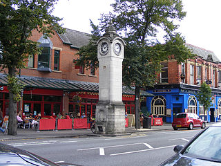
Didsbury railway station is a former station in Didsbury, in the southern suburbs of Manchester, England, United Kingdom. The station was located on Wilmslow Road, just north of the junction with Barlow Moor Road and opposite Didsbury Library. Nothing now remains of the old station buildings, which have been demolished, but the surviving white Portland stone clock tower is a local landmark. Didsbury is now served by Didsbury Village tram stop which is close to the site of the former railway station.


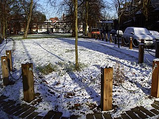
Barlow Moor is an area of Manchester, England. It was originally an area of moorland between Didsbury and Chorlton-cum-Hardy and was named after the Barlow family of Barlow Hall. Barlow Moor Road runs through the area and connects to Wilmslow Road at the southern end and Manchester Road at the northern end. Southern Cemetery and Chorlton Park are landmarks on the route. Immediately adjacent to the northwest corner of the cemetery, also on Barlow Moor Road, is the Manchester Crematorium which opened in 1892, the second in the United Kingdom. The architects were Steinthal and Solomons who chose to revive the Lombard-Romanesque style. Another notable building is the Chorlton Park Apartments, 2002.

Kingsway is a dual carriageway in Greater Manchester, England, which runs from Levenshulme to Cheadle. It is approximately 7.3 mi (11.7 km) long and is a link road between the city centre and the southern suburbs of Greater Manchester, forming part of the A34. Kingsway was built in the late 1920s between Levenshulme and Parrs Wood, and was originally designed as a combined road and tram route. The tram tracks were eventually removed and the road was later extended to bypass Cheadle and join onto the M60 motorway.

The Didsbury Campus on Wilmslow Road, Didsbury, Manchester, England, originally a private estate, was part of the Manchester Metropolitan University; the oldest building on the site dated to around 1785. It became a theological college for the Wesleyan Methodist Church in 1842, about the same time as a chapel which later became part of the college was built. These buildings are now all listed.
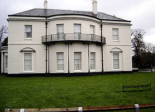
Parrs Wood House is an 18th-century Georgian villa in the Parrs Wood area of Didsbury, Manchester, England. It was described by Pevsner as "a poorer man's Heaton Hall." It was designated a Grade II* listed building on 25 February 1952.
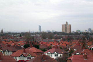
Manchester is a city in Northwest England. The M20 postcode area of the city includes the suburbs of Didsbury and Withington. This postcode area contains 66 listed buildings that are recorded in the National Heritage List for England. Of these, four are listed at Grade II*, the middle of the three grades, and the others are at Grade II, the lowest grade. The area is mainly residential, and most of the listed buildings are houses and associated structures. The other listed buildings include churches and structures in churchyards, hotels and public houses, civic buildings, buildings in the Didsbury Campus of Manchester Metropolitan University, a former hospital and its lodges, banks, a clock tower, a school, a milestone and a war memorial.


