The Liverpool and Manchester Railway (L&MR) was the first inter-city railway in the world. It opened on 15 September 1830 between the Lancashire towns of Liverpool and Manchester in England. It was also the first railway to rely exclusively on locomotives driven by steam power, with no horse-drawn traffic permitted at any time; the first to be entirely double track throughout its length; the first to have a true signalling system; the first to be fully timetabled; and the first to carry mail.

Manchester Piccadilly is the main railway station of the city of Manchester, in the metropolitan county of Greater Manchester, England. Opened originally as Store Street in 1842, it was renamed Manchester London Road in 1847 and became Manchester Piccadilly in 1960. Located to the south-east of the city centre, it hosts long-distance intercity and cross-country services to national destinations including London, Birmingham, Nottingham, Glasgow, Edinburgh, Cardiff, Bristol, Exeter, Plymouth, Reading, Southampton and Bournemouth; regional services to destinations in Northern England including Liverpool, Leeds, Sheffield, Newcastle and York; and local commuter services around Greater Manchester. It is one of 19 major stations managed by Network Rail. The station has 14 platforms: 12 terminal and two through platforms. Piccadilly is also a major interchange with the Metrolink light rail system with two tram platforms in its undercroft.

Castlefield is an inner-city conservation area in Manchester, North West England. The conservation area which bears its name is bounded by the River Irwell, Quay Street, Deansgate and Chester Road. It was the site of the Roman era fort of Mamucium or Mancunium which gave its name to Manchester. It was the terminus of the Bridgewater Canal, the world's first industrial canal, built in 1764; the oldest canal warehouse opened in 1779. The world's first passenger railway terminated here in 1830, at Liverpool Road railway station and the first railway warehouse opened here in 1831.

Vivekananda Setu is a bridge over the Hooghly River in West Bengal, India. It links the city of Howrah, at Bally, to Kolkata, at Dakshineswar. Completed on 1931, it is a multispan truss bridge and was built to primarily to provide direct road and rail connectivity between the Calcutta Port and the major railhead at Howrah railway station on the West bank of the Hooghly River. It is 2,887 feet (880 m) long having 9 spans in total. The famous Dakshineswar Kali Temple is situated on the banks of the Hooghly River near the bridge. The bridge is one of the four bridges linking Howrah and Kolkata. A new road bridge, the Nivedita Setu, was constructed 50 m (160 ft) downstream in 2007 due to weakening of the Vivekanada Setu caused by its ageing.

The Royal Border Bridge spans the River Tweed between Berwick-upon-Tweed and Tweedmouth in Northumberland, England. It is a Grade I listed railway viaduct built between 1847 and 1850, when it was opened by Queen Victoria. It was designed by Robert Stephenson. It was built for the York, Newcastle and Berwick Railway and is still in regular use today, as part of the East Coast Main Line. Despite its name, the bridge does not in fact span the border between England and Scotland, which is approximately three miles further north.
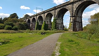
The Sankey Viaduct is a railway viaduct in North West England. It is a designated Grade I listed building and has been described as being "the earliest major railway viaduct in the world".

The Landore viaduct is a railway viaduct over the Swansea valley and the River Tawe at Landore in south Wales. It provides a link between Swansea city center and the West Wales Line to the South Wales Main Line. The valley crossing provides a panoramic view of Landore, Kilvey Hill, the Liberty Stadium and the Swansea Enterprise Park.

The Store Street Aqueduct in central Manchester, England, was built in 1798 by Benjamin Outram on the Ashton Canal. A Grade II* listed building, it is built on a skew of 40° across Store Street, and is believed to be the first major aqueduct of its kind in Great Britain and the oldest still in use today.
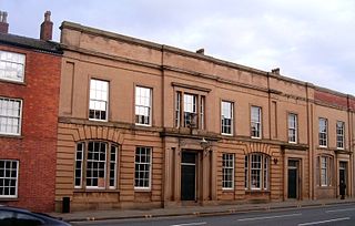
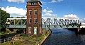
Liverpool Road is a former railway station on the Liverpool and Manchester Railway in Manchester, England; it opened on 15 September 1830. The station was the Manchester terminus of the world's first inter-city passenger railway in which all services were hauled by timetabled steam locomotives. It is the world's oldest surviving terminal railway station. With tracks running at a first floor level behind the building, it could also be considered one of the world's first elevated railway stations.

Laigh Milton Viaduct is a railway viaduct near Laigh Milton mill to the west of Gatehead in East Ayrshire, Scotland, about five miles west of Kilmarnock. It is probably the world's earliest surviving railway viaduct on a public railway, and the earliest known survivor of a type of multi-span railway structure subsequently adopted universally.

The Wharncliffe Viaduct is a brick-built viaduct that carries the Great Western Main Line railway across the Brent Valley, between Hanwell and Southall, Ealing, UK, at an elevation of 20 metres (66 ft). The viaduct, built in 1836–7, was constructed for the opening of the Great Western Railway (GWR). It is situated between Southall and Hanwell stations, the latter station being only a very short distance away to the east.

Stockport Viaduct carries the West Coast Main Line across the valley of the River Mersey in Stockport, Greater Manchester, England. It is one of the largest brick structures in the United Kingdom and a major structure of the early railway age. It is immediately north of Stockport railway station.

A skew arch is a method of construction that enables an arch bridge to span an obstacle at some angle other than a right angle. This results in the faces of the arch not being perpendicular to its abutments and its plan view being a parallelogram, rather than the rectangle that is the plan view of a regular, or "square" arch.

Ordsall Chord, also known as the Castlefield Curve, is a short railway line in Ordsall, Salford, England, which links Manchester Piccadilly and Manchester Oxford Road to Manchester Victoria, designed to increase capacity and reduce journey times into and through Manchester. It allows trains to run from Leeds, Newcastle and Redcar Central direct to Manchester Airport.

The Monmouth Viaduct or Chippenham Meadow Viaduct is a 20-arch 183m red sandstone viaduct, with two 23m steel lattice-girder spans over the river. It carried the Coleford, Monmouth, Usk & Pontypool Railway line across the River Wye at Monmouth, Wales. A further river crossing by the Ross and Monmouth Railway was later built nearby.

Swin Bridge is the local name for a skew arch bridge in County Durham. It was built in 1830 for the Haggerleases branch of the Stockton and Darlington Railway, crossing the River Gaunless at Cockfield. It is important as an early example of the masonry arch skew bridge, and the first used to carry a railway.

The Nepean River railway bridge is a heritage-listed railway bridge that carries the Main Southern railway line across Menangle Road and the Nepean River located at the outer south-western Sydney settlement of Menangle in the Wollondilly Shire local government area of New South Wales, Australia. It was designed by John Whitton as the Engineer-in-Chief, of the New South Wales Government Railways and NSW Department of Public Works. The railway bridge was built in 1863 by Messers Peto, Brassey and Betts. It is also known as Menangle rail bridge over Nepean River and Menangle Railway Bridge. The property was added to the New South Wales State Heritage Register on 2 April 1999.

Dinting Viaduct is a 19th-century railway viaduct in Glossopdale in Derbyshire, England, that carries the Glossop Line over a valley at the village of Dinting. It crosses the Glossop Brook and the A57 road between Manchester and Sheffield.

The Castlefield corridor is a railway corridor between Castlefield junction and Fairfield Street junction in Greater Manchester, England. The corridor forms the eastern end of the southerly Liverpool–Manchester line.

Bushey Arches Viaduct is a railway bridge on the West Coast Main Line immediately north of Bushey railway station, between Bushey and Watford, in Hertfordshire, Eastern England, just north-west of London.