
The Bridgewater Hall is a concert venue in Manchester city centre, England. It cost around £42 million to build in the 1990s, and hosts over 250 performances a year.

The 1996 Manchester bombing was an attack carried out by the Provisional Irish Republican Army (IRA) on Saturday 15 June 1996. The IRA detonated a 1,500-kilogram (3,300 lb) lorry bomb on Corporation Street in the centre of Manchester, England. It was the biggest bomb detonated in Great Britain since the Second World War. It targeted the city's infrastructure and economy and caused significant damage, estimated by insurers at £700 million, a sum surpassed only by the 1993 Bishopsgate bombing, also by the IRA, and the 2001 September 11 attacks.

The Clair–Fort Kent Bridge is a steel truss bridge crossing the Saint John River between Clair, New Brunswick in Canada and Fort Kent, Maine in the United States.

The Lowry is a theatre and gallery complex at Salford Quays, Salford, Greater Manchester, England. It is named after the early 20th-century painter L. S. Lowry, known for his paintings of industrial scenes in North West England. The complex opened on 28 April 2000 and was officially opened on 12 October 2000 by Queen Elizabeth II.

Hyperboloid structures are architectural structures designed using a hyperboloid in one sheet. Often these are tall structures, such as towers, where the hyperboloid geometry's structural strength is used to support an object high above the ground. Hyperboloid geometry is often used for decorative effect as well as structural economy. The first hyperboloid structures were built by Russian engineer Vladimir Shukhov (1853–1939), including the Shukhov Tower in Polibino, Dankovsky District, Lipetsk Oblast, Russia.

Manchester Arndale is a large shopping centre in Manchester, England. It was constructed in phases between 1972 and 1979, at a cost of £100 million. Manchester Arndale is the largest of the chain of Arndale Centres built across the UK in the 1960s and 1970s. It was redeveloped after the 1996 Manchester bombing.

Manchester Civil Justice Centre is a governmental building in Manchester, England. Completed in 2007, it houses Manchester's county court and the Manchester District Registry of the High Court, the city's family proceedings court, the district probate registry, and the regional and area offices of the Court Service.
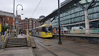
Shudehill Interchange is a transport hub between Manchester Victoria station and the Northern Quarter in Manchester city centre, England, which comprises a Metrolink stop and a bus station.

MediaCityUK is a 200-acre (81 ha) mixed-use property development on the banks of the Manchester Ship Canal in Salford, Greater Manchester, England. The project was developed by Peel Media; its principal tenants are media organisations and the Quayside MediaCityUK shopping centre. The land occupied by the development was part of the Port of Manchester and Manchester Docks.
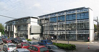
The Centenary Building is a building at the University of Salford in Greater Manchester, England. It was completed in December 1995 and opened in 1996 and was designed by the architect Stephen Hodder.
The Chorlton Park Apartments, is a green apartment building in Chorlton, Manchester, England. It was designed by architect Roger Stephenson and built as part of collaboration between Tom Bloxham's development company Urban Splash and Irwell Valley in 2002.
Bridge to Nowhere is a nickname used to refer to various unfinished structures around the M8 motorway in the centre of Glasgow, Scotland. They were built in the 1960s as part of the Glasgow Inner Ring Road project but left incomplete for several years. One "bridge", at Charing Cross, was completed in the 1990s as an office block. The Anderston Footbridge, a pedestrian bridge south of St Patrick's church, was finally completed in 2013 as part of a walking and cycling route.

North Tower is a high-rise residential building on Victoria Bridge Street in Salford, England. The building is 23 stories tall with a podium at the base, which gives it a total height of 80 metres (260 ft), making it one of the tallest buildings in Salford. The building is in the City of Salford, just north of the River Irwell and less than 100 metres (330 ft) from Manchester Cathedral on the other side of the river. The top twelve floors contain 96 apartments, with the lower ten used as a Premier Inn hotel.

The Hulme Arch Bridge in Hulme, Manchester, England, supports Stretford Road as it passes over Princess Road, and is located at grid reference SJ838968. The construction of the bridge formed part of the regeneration of the Hulme district of Manchester, both by re-establishing the former route of Stretford Road, which had been cut into two halves by the construction of Princess Road in 1969, and by providing a local landmark. The location was previously occupied by a footbridge.
Grimshaw Architects is an architectural firm based in London. Founded in 1980 by Sir Nicholas Grimshaw, the firm was one of the pioneers of high-tech architecture. In particular, they are known for their design of transport projects including Amsterdam Bijlmer ArenA railway station, Waterloo International railway station and the award-winning Southern Cross railway station which was the recipient of the Royal Institute of British Architects Lubetkin Prize. Grimshaw is behind the design of the Sustainability Pavilion, an innovative net-zero building, for Expo 2020. The firm currently has offices in Los Angeles, New York, London, Paris, Dubai, Melbourne and Sydney, employing over 600 staff.

The Old Wellington Inn is a half-timbered pub in Manchester city centre, England. It is part of Shambles Square, which was created in 1999, and is near Manchester Cathedral. It is a Grade II listed building.
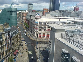
Corporation Street is a major thoroughfare in Manchester city centre. It runs from Dantzic Street to the junction of Cross Street and Market Street. Major buildings located on or adjacent to the street include the Arndale Centre, Exchange Square, The Printworks, Urbis and New Century Hall next to the CIS Tower.

BCSA Ltd is a trade association for the structural steel industry in the UK and Ireland.

One Angel Square is an office building in Manchester, England. Construction work began in 2010 and was completed in February 2013. The landmark building is the head office of the Co-operative Group. Standing 72.5 metres tall, the building forms the centrepiece of the new £800 million NOMA development in the Angel Meadows area of Manchester city centre. The building cost at least £105 million to construct and was sold on leaseback terms in 2013 for £142 million.

Gateway House in Manchester, England, is a modernist office block above a row of shops designed by Richard Seifert & Partners and completed in 1969. It replaced a row of 19th-century railway warehouses on the approach to Manchester Piccadilly station. The building, which differed from much of Seifert's contemporary work in that it departed from the bare concrete brutalist style which had become his trademark, was nicknamed the "lazy S" and was reputedly designed as a doodle.


