
Manchester Piccadilly is the main railway station of the city of Manchester,in the metropolitan county of Greater Manchester,England. Opened originally as Store Street in 1842,it was renamed Manchester London Road in 1847 and became Manchester Piccadilly in 1960. Located to the south-east of the city centre,it hosts long-distance intercity and cross-country services to national destinations including London,Birmingham,Nottingham,Glasgow,Edinburgh,Cardiff,Bristol,Exeter,Plymouth,Reading,Southampton and Bournemouth;regional services to destinations in Northern England including Liverpool,Leeds,Sheffield,Newcastle and York;and local commuter services around Greater Manchester. It is one of 19 major stations managed by Network Rail. The station has 14 platforms:12 terminal and two through platforms. Piccadilly is also a major interchange with the Metrolink light rail system with two tram platforms in its undercroft.

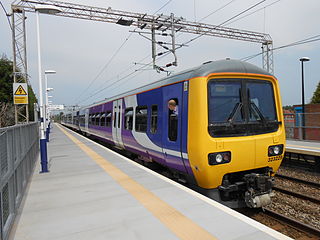
Manchester Metrolink is a tram/light rail system in Greater Manchester,England. The network has 99 stops along 64 miles (103 km) of standard-gauge route,making it the most extensive light rail system in the United Kingdom. Over the 2022/23 financial year 36 million passenger journeys were made on the system.
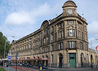
Manchester Victoria station in Manchester,England,is a combined mainline railway station and Metrolink tram stop. Situated to the north of the city centre on Hunts Bank,close to Manchester Cathedral,it adjoins Manchester Arena which was constructed on part of the former station site in the 1990s. Opened in 1844 and part of the Manchester station group,Manchester Victoria is Manchester's second busiest railway station after Piccadilly,and is the busiest station managed by Northern.

Manchester City Centre is the central business district of Manchester,England,within the confines of Great Ancoats Street,A6042 Trinity Way,and A57(M) Mancunian Way,which collectively form an inner ring road. The City Centre ward had a population of 17,861 at the 2011 census.
The Styal line is a suburban commuter railway line which runs through south Manchester,England;it commences at Slade Lane Junction,1.2 miles (1.9 km) south of Manchester Piccadilly,and ends 12 miles (19 km) south at Wilmslow.

Piccadilly Gardens is a green space in Manchester city centre,England,on the edge of the Northern Quarter.

Picc-Vic was a proposed,and later cancelled,underground railway designed in the early 1970s with the purpose of connecting two major mainline railway termini in Manchester city centre,England. The name Picc-Vic was a contraction of the two key station names,Manchester Piccadilly and Manchester Victoria. The proposal envisaged the construction of an underground rail tunnel across Manchester city centre. The scheme was abandoned in 1977 during its proposal stages due to Westminster's lack of willingness to invest in Manchester. The view was that the scheme still retained two large and expensive-to-maintain terminal stations in Manchester while other similarly sized cities had reduced their terminals to one.

Piccadilly Gardens is a tram stop in Zone 1 of Greater Manchester's Metrolink light rail system. It is located beside Piccadilly Gardens in Manchester city centre,and serves both as a transport hub,and interchange station.

The transport infrastructure of Greater Manchester is built up of numerous transport modes and forms an integral part of the structure of Greater Manchester and North West England –the most populated region outside of South East England which had approximately 301 million annual passenger journeys using either buses,planes,trains or trams in 2014. Its position as a national city of commerce,education and cultural importance means the city has one of the largest and most thorough transport infrastructures which is heavily relied upon by its 2.8 million inhabitants in the Greater Manchester conurbation and further afield in the North West region. Public transport comes under the jurisdiction of Transport for Greater Manchester.

Droylsden is a tram stop on the East Manchester Line (EML) of Greater Manchester's light-rail Metrolink system. It opened on 11 February 2013,after a three-day free trial for local residents. The stop was constructed as part of Phase 3a of the Metrolink's expansion,and is located in Droylsden town centre,a part of Tameside,England.

The history of Manchester Metrolink begins with its conception as Greater Manchester's light rail system in 1982 by the Greater Manchester Passenger Transport Executive,and spans its inauguration in 1992 and the successive phases of expansion.
The Manchester station group is a station group of four railway stations in Manchester city centre,England;this consists of Manchester Piccadilly,Manchester Oxford Road,Manchester Victoria and Deansgate. The station group is printed on national railway tickets as MANCHESTER STNS. For passengers travelling from one of the 91 National Rail stations in Greater Manchester,the four stations are printed as MANCHESTER CTLZ which additionally permits the use of Metrolink tram services in Zone 1.
This timeline lists significant events in the history of Greater Manchester's light rail network called the Manchester Metrolink.

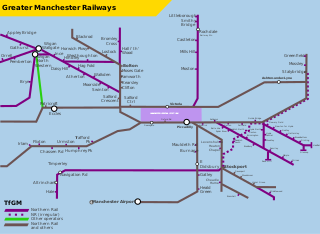
The Bury Line is a light rail/tram line on the Manchester Metrolink in Greater Manchester. It runs from Manchester Victoria station to Bury Interchange in the north. The entire line runs along a converted heavy rail line,and was reopened with the Altrincham Line,another Metrolink line converted from heavy rail,as part of Phase 1 of the Metrolink's expansion.

The Altrincham Line is a tram line of the Manchester Metrolink running from Manchester to Altrincham in Greater Manchester. Originally a railway line,it was,along with the Bury Line,converted into a tramway during 1991–92,as part of the first phase of the Metrolink system.

The East Manchester Line (EML) is a tram line of the Manchester Metrolink in Greater Manchester,England,running from Manchester to Ashton-under-Lyne via Droylsden and Audenshaw. The line opened in 2013 as part of phase three of the system's expansion.

Zone 1 of the Manchester Metrolink light rail network is the heart of the system where all of the other lines converge. Its boundaries approximately mirror the city's Inner Ring Road. Within Zone 1,first opened in 1992 as the City Zone,trams largely run along semi-pedestrianised streets rather than on their own separate alignment.

East Chinatown is a Chinese neighbourhood located in the city of Toronto's east end in Riverdale and one of the several Chinatowns in Toronto. It was formed during the early 1970s and is centred on Gerrard Street East between Broadview Avenue and Carlaw Avenue.


