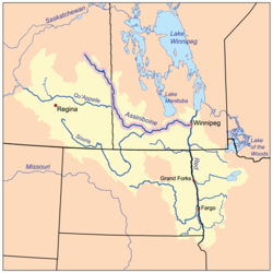
The Assiniboine River is a 1,070-kilometre (660 mi) river that runs through the prairies of Western Canada in Saskatchewan and Manitoba. It is a tributary of the Red River. The Assiniboine is a typical meandering river with a single main channel embanked within a flat, shallow valley in some places and a steep valley in others. Its main tributaries are the Qu'Appelle, Souris, and Whitesand Rivers. For early history and exploration see Assiniboine River fur trade.
Canora-Pelly is a provincial electoral district for the Legislative Assembly of Saskatchewan, Canada.
Highway 9 is a paved, undivided provincial highway in the Canadian province of Saskatchewan. It runs from North Dakota Highway 8 at the US border near Port of Northgate until it transitions into Provincial Road 283 at the Manitoba provincial boundary.
The Saskota Flyway is known as the International Road to Adventure, because it takes you from Hudson Bay, Saskatchewan, all the way south to Bismarck, North Dakota.
Rama is a village in the Canadian province of Saskatchewan within the Rural Municipality of Invermay No. 305 and Census Division No. 9. It is located 44 km west of Canora and 60 km east of Wadena at the intersection of Highway 5 and Highway 754.
The Beaver Hills are a range of hills located in the Canadian province of Saskatchewan.

The Rural Municipality of Good Lake No. 274 is a rural municipality (RM) in the Canadian province of Saskatchewan within Census Division No. 9 and SARM Division No. 4.

The Rural Municipality of Invermay No. 305 is a rural municipality (RM) in the Canadian province of Saskatchewan within Census Division No. 9 and SARM Division No. 4.

Sturgeon River is a river in the Hudson Bay drainage basin in the central part of the Canadian province of Saskatchewan. It flows from its source in the Waskesiu Hills in Prince Albert National Park to the North Saskatchewan River, just west of the city of Prince Albert.

Spirit Creek is a river located in the Assiniboine River watershed in the Canadian province of Saskatchewan. It begins east of Rama and flows south-east into the north end of Good Spirit Lake. Along its route, it crosses Highway 5 and the CN Railway 3 kilometres (2 mi) west of Buchanan. Just over 3 kilometres (2 mi) south of Buchanan, it crosses Highway 47 and flows into Patterson Lake. From Patterson Lake, it empties into the north end of Good Spirit Lake.

Piwei River is a river in the east-central part of the Canadian province of Saskatchewan in the boreal forest ecozone of Canada. It begins at the western end of the Porcupine Hills at Piwei Lakes and heads in an easterly direction through a glacier-formed valley and into the Etomami River, which is a tributary of the Red Deer River.

Good Spirit Lake is a lake on the eastern side of the Canadian province of Saskatchewan. It is a shallow lake notable for its naturally sandy beaches, parks, and sand dunes. One of Saskatchewan's six founding provincial parks, Good Spirit Lake Provincial Park, surrounds the western and southern shores of the lake. The lake is in the RM of Good Lake No. 274 and Yorkton, 48 kilometres (30 mi) to the south, is the nearest city. The hamlets of Burgis Beach and Canora Beach–the only two communities on the lake–are located on the eastern shore. The southern shore of the lake is accessed from Highway 229 and the northern shore is accessed from Highway 651. Highway 47 runs north to south west of the lake and Good Spirit Lake Provincial Park.
Theodore Reservoir is a man-made reservoir along the course of the Whitesand River in the Canadian province of Saskatchewan. The lake was formed with the building of Theodore Dam in 1964. The reservoir and dam were named after the nearby community of Theodore. Whitesand River is the primary inflow and outflow for the reservoir. Lawrie Creek, which begins in the Beaver Hills, flows into the lake on the western side near the dam.

Yorkton Creek, formally known as Little Whitesand River, is a river in the south-east region of the Canadian province of Saskatchewan. The river begins at Leech Lake, south of Yorkton, and flows north into the Whitesand River. The Whitesand River flows east into the Assiniboine River, which is a major tributary of the Red River. While Yorkton Creek begins at Leech Lake, its main tributary, Crescent Creek, has its headwaters in the Beaver Hills to the west.
Crescent Creek is a river in the south-east region of the Canadian province of Saskatchewan. The river begins in the Beaver Hills and flows in an easterly direction into Crescent Lake. Crescent Creek is a tributary of Yorkton Creek, which flows north into the Whitesand River–a tributary of the Assiniboine River.

Cowan River is a river in the west-central part of the Canadian province of Saskatchewan in the boreal forest ecozone of Canada. The river begins at Cowan Lake Dam near the northern end of Cowan Lake and flows north-west through muskeg and forest to meet Beaver River. Beaver River then flows into Lac Île-à-la-Crosse and the Churchill River. The entirety of Cowen River is within the Northern Saskatchewan Administration District and while there are no communities along its course, the towns of Big River and Spiritwood are in its watershed.
Elaine Lake is a lake in the Canadian province of Saskatchewan. It is located north of Prince Albert National Park in the Thunder Hills of the Northern Saskatchewan Administration District.
Makwa River is a river in the Canadian province of Saskatchewan in the transition zone between parkland and boreal forest. Makwa is Cree for Loon. The upper reaches of the Makwa River's watershed reach just across the border into Alberta and includes lakes such as Hewett, Ministikwan, Makwa, and Jumbo.
Wood River is a river in the Canadian province of Saskatchewan. It has its source in the Wood Mountain Hills of south-western Saskatchewan and flows in a north-easterly direction to its mouth at Old Wives Lake. Old Wives Lake is a salt water lake with no outflow. As a result, the drainage basin of Wood River is an endorheic one. Along the course of the river, there are several parks, historical sites, and small towns.
Cypress Lake is an interbasin transfer reservoir in the Canadian province of Saskatchewan on the southern slopes of the Cypress Hills in the Rural Municipality of Reno No. 51. The reservoir was created by the damming of the east and west sides of a much smaller Cypress Lake in the late 1930s. There is a provincial recreation site on the southern shore and a wildlife refuge on Heglund Island in the lake. Access to the lake is from Township Road 60 off of Highway 21.