| Wind Mountain | |
|---|---|
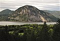
 West aspect | |
| Highest point | |
| Elevation | 1,907 ft (581 m) [1] |
| Prominence | 947 ft (289 m) [1] |
| Isolation | 2.41 mi (3.88 km) [2] |
| Coordinates | 45°42′36″N121°45′21″W / 45.7098639°N 121.7557228°W [3] |
| Geography | |
 Wind Mountain Location of Wind Mountain in Washington  Wind Mountain Wind Mountain (the United States) | |
 | |
| Location | Skamania County, Washington, U.S. |
| Parent range | Cascade Range |
| Topo map | USGS Carson |
| Geology | |
| Rock age | late Miocene to Pliocene |
| Mountain type | intrusive igneous |
| Rock type | quartz diorite |
| Climbing | |
| First ascent | Native Americans |
| Easiest route | class 1 hiking trail |
Wind Mountain is a 1,907-foot-elevation (581-meter) summit located in Skamania County of Washington state. [3]