Related Research Articles

One Tree Hill is a town on the outskirts of Adelaide, South Australia. It is located in the City of Playford.

The City of Tea Tree Gully is a local council in the Australian state of South Australia, in the outer north-eastern suburbs of Adelaide. The major business district in the city is at Modbury, where Westfield Tea Tree Plaza, the Civic Centre and the library are located.
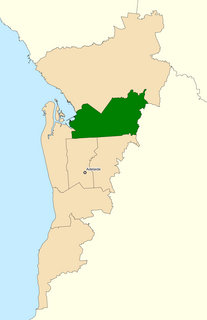
The Division of Makin is an electoral division for the Australian House of Representatives located in the northeastern suburbs of Adelaide. The 130 km² seat covers an area from Little Para River and Gould Creek in the north-east to Grand Junction Road in the south and Port Wakefield Road in the west, including the suburbs of Banksia Park, Fairview Park, Golden Grove, Greenwith, Gulfview Heights, Ingle Farm, Mawson Lakes, Modbury, Para Hills, Para Vista, Pooraka, Redwood Park, Ridgehaven, Salisbury East, Salisbury Heights, St Agnes, Surrey Downs, Tea Tree Gully, Valley View, Vista, Walkley Heights, Wynn Vale, Yatala Vale, and parts of Gepps Cross and Hope Valley.

Para Hills is a residential suburb of Adelaide, South Australia. There is a light aircraft airport close to its boundary, and numerous sporting facilities, abundant parks and schools and two medium-sized shopping centres. Most of the suburb is in the City of Salisbury while some is in the City of Tea Tree Gully.

Gulfview Heights is a small suburb of Adelaide, South Australia and is within the City of Salisbury and City of Tea Tree Gully local government area. It is adjacent to Wynn Vale, Salisbury East and Para Hills.
Wynn Vale is an outer north-eastern suburb of Adelaide, South Australia and is located within the City of Tea Tree Gully local government area. It is adjacent to Golden Grove, Modbury Heights, Surrey Downs, Salisbury East and Para Hills. It is located approximately 20 km north-east of the city of Adelaide.

Greenwith is an outer-north-eastern suburb of Adelaide, the capital city of South Australia, and is within the City of Tea Tree Gully local government area. It is adjacent to Golden Grove and Salisbury Heights. Greenwith is the northernmost part of the Golden Grove urban land development.
Surrey Downs is a northeastern suburb of Adelaide, South Australia. It is located in the City of Tea Tree Gully local government area, and is adjacent to Wynn Vale, Golden Grove, Fairview Park and Redwood Park.
Upper Hermitage is an outer northeastern rural suburb of Adelaide, South Australia. It is located in the City of Tea Tree Gully and Adelaide Hills Council local government areas, and is adjacent to the rural districts of Yatala Vale and Gould Creek.
Gould Creek is an outer northeastern rural suburb of Adelaide, South Australia. Gould Creek is located in the City of Tea Tree Gully and City of Playford local government areas, and is adjacent to Greenwith, Salisbury Heights and Hillbank, as well as the rural districts of Yatala Vale and Upper Hermitage and the town of One Tree Hill.

Valley View is a suburb of Adelaide, South Australia. It spans three separate local government areas. They are the City of Salisbury, the City of Port Adelaide Enfield, and the City of Tea Tree Gully. The suburb's boundaries are defined by the intersection of Walkleys, Grand Junction and North East Roads in the south, and Wright and Kelly Roads in the north and east.

Modbury North is a suburb 14 km northeast of Adelaide, capital city of South Australia.
Modbury Heights is a medium-sized suburb in the City of Tea Tree Gully, Adelaide. The suburb is located in the foothills of the Mount Lofty Ranges around 16 kilometres north east of the Central business district. Much of the suburb is residential but there is a small shopping area along Ladywood Road.

Cobbler Creek Recreation Park is a 266-hectare (657-acre) protected area located in South Australia about 19 kilometres (12 mi) north of the Adelaide city centre in the suburb of Salisbury East. Originally part of the lands of the Kaurna aboriginal people, it was farmed from European settlement of South Australia until the declaration of the park in 1989.

Salisbury is a northern suburb in Adelaide, South Australia. It is the seat of the City of Salisbury, and in the South Australian Legislative Assembly electoral district of Ramsay and the Australian House of Representatives division of Spence. The suburb is a service area for the City of Salisbury district, with an abundance of parklands, shops, cafes and restaurants. Parabanks Shopping Centre is also located in Salisbury, which includes Woolworths, Coles and Big W as its signature retailers.

The City of Elizabeth was a local government area located in the northern suburbs of Adelaide and seated at Elizabeth from 1964 to 1997.
Golden Grove is an outer north-eastern suburb of Adelaide, South Australia and is within the City of Tea Tree Gully local government area. It is adjacent to Wynn Vale, Surrey Downs, Greenwith, Yatala Vale, Fairview Park, and Salisbury East.
The District Council of Yatala was a local government area of South Australia established in 1853 and abolished in 1868.

Dry Creek or Dry Creek Drain is a seasonal stream in South Australia which passes through the Adelaide suburbs of Modbury, Walkley Heights and Pooraka. The nearby suburb of Dry Creek and Dry Creek railway station are named after the stream.

The Hundred of Yatala is a cadastral unit of hundred in South Australia covering much of the Adelaide metropolitan area north of the River Torrens. It is one of the eleven hundreds of the County of Adelaide stretching from the Torrens in the south to the Little Para River in the north; and spanning from the coast in the west to the Adelaide foothills in the east. It is roughly bisected from east to west by Dry Creek. It was named in 1846 by Governor Frederick Robe, Yatala being likely derived from yartala, a Kaurna word referring to the flooded state of the plain either side of Dry Creek after heavy rain.
References
- ↑ Chapter 12 'Weeding Out Spurious Etymologies: Toponyms On The Adelaide Plains' (Rob Amery) in: Luise Hercus; Flavia Hodges; Jane Simpson, eds. (March 2009). The Land is a Map: Placenames of Indigenous Origin in Australia. ANU Press. pp. 165–180. ISBN 9781921536571.
Yatala most likely derives from yertalla 'water running by the side of a river; inundation; cascade'. As Manning (1986:238) observes 'in winter when water flowed from the hills, over the plains, the Dry Creek area became a morass'.
- ↑ Premier Postal History. "Post Office List". Premier Postal Auctions. Retrieved 26 May 2011.
- ↑ UBD Adelaide directory (1999; 47th ed.) Universal Press. ISBN 0-7319-1033-8