The City of Tea Tree Gully is a local council in the Australian state of South Australia, in the outer north-eastern suburbs of Adelaide. The major business district in the city is at Modbury, where Westfield Tea Tree Plaza, the Civic Centre and the library are located.
Waterfall Gully is an eastern suburb of the South Australian capital city of Adelaide. It is located in the foothills of the Mount Lofty Ranges around 5 km (3.1 mi) east-south-east of the Adelaide city centre. For the most part, the suburb encompasses one long gully with First Creek at its centre and Waterfall Gully Road running adjacent to the creek. At the southern end of the gully is First Falls, the waterfall for which the suburb was named. Part of the City of Burnside, Waterfall Gully is bounded to the north by the suburb of Burnside, from the north-east to south-east by Cleland National Park, to the south by Crafers West, and to the west by Leawood Gardens and Mount Osmond.

Greenwith is an outer-north-eastern suburb of Adelaide, the capital city of South Australia, and is within the City of Tea Tree Gully local government area. It is adjacent to Golden Grove and Salisbury Heights. Greenwith is the northernmost part of the Golden Grove urban land development.
Surrey Downs is a northeastern suburb of Adelaide, South Australia. It is located in the City of Tea Tree Gully local government area, and is adjacent to Wynn Vale, Golden Grove, Fairview Park and Redwood Park.

Houghton is a small town near Adelaide, South Australia. It is located in the Adelaide Hills, in the City of Tea Tree Gully and the Adelaide Hills Council local government areas between Tea Tree Gully and Inglewood on the North East Road.
Yatala Vale is an outer northeastern rural suburb of Adelaide, South Australia. It is located in the City of Tea Tree Gully local government area, and is adjacent to Golden Grove and Fairview Park, as well as the rural districts of Upper Hermitage and Gould Creek.
Upper Hermitage is an outer northeastern rural suburb of Adelaide, South Australia. It is located in the City of Tea Tree Gully and Adelaide Hills Council local government areas, and is adjacent to the rural districts of Yatala Vale and Gould Creek.

Vista is a small north-eastern suburb of Adelaide, South Australia and is within the City of Tea Tree Gully local government area. It is adjacent to Houghton, Tea Tree Gully, St Agnes and Hope Valley.

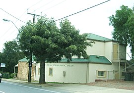
Modbury is a suburb of Adelaide, South Australia in the City of Tea Tree Gully. Modbury is located at the end of the Adelaide O-Bahn and is home to the Tea Tree Plaza shopping complex and a Hospital.

Valley View is a suburb of Adelaide, South Australia. It spans three separate local government areas. They are the City of Salisbury, the City of Port Adelaide Enfield, and the City of Tea Tree Gully. The suburb's boundaries are defined by the intersection of Walkleys, Grand Junction and North East Roads in the south, and Wright and Kelly Roads in the north and east.

Banksia Park is a north-eastern suburb located 20 km from the city centre of Adelaide, South Australia, within the City of Tea Tree Gully.

Mundulla is a town and a locality in south eastern South Australia. The town is located in the local government area of Tatiara District Council about 278 kilometres (173 mi) south east of the state capital of Adelaide.

Kangarilla is a small rural town and locality around 33 km (21 mi) from Adelaide city centre, in South Australia. The area, formerly inhabited by Kaurna people, was settled by Europeans in 1840, not long after the British colonisation of South Australia. Today it lies within the City of Onkaparinga local government area, and has postcode 5157. At the 2016 census, Kangarilla had a population of 896.
Queenstown is a north-western suburb of Adelaide about 10.5 km from the CBD, in the state of South Australia, Australia and the city council area of Port Adelaide Enfield.

Anstey Hill Recreation Park is a 362-hectare (890-acre) protected area established in 1989 and located approximately 19 kilometres (12 mi) northeast of Adelaide, South Australia. The park is a significant reserve of bushland in the foothills of the Mount Lofty Ranges and is home to rare or vulnerable native plants and animals, and problematic invasive species. It is managed by the City of Tea Tree Gully, the Department of Environment, Water and Natural Resources and a volunteer group—The Friends of Anstey Hill. The park is designed for recreational walking and has no visitor facilities. It is managed in association with the regional planning initiative known as of Yurrebilla, the Greater Mount Lofty Parklands.

St Agnes is a suburb of Adelaide, South Australia. It is around 15 km northeast of the city centre. It is located in the City of Tea Tree Gully.
Golden Grove is an outer north-eastern suburb of Adelaide, South Australia and is within the City of Tea Tree Gully local government area. It is adjacent to Wynn Vale, Surrey Downs, Greenwith, Yatala Vale, Fairview Park, and Salisbury East.
William Haines was a South Australian politician affectionately known as the "King of Tea Tree Gully".
The District Council of Highercombe was a local government area in South Australia from 1853 to 1935.

The Tea Tree Gully Heritage Museum, formerly the Highercombe Hotel is a local history museum located in Tea Tree Gully, South Australia. It is one of the three museums operated by the History Trust of South Australia. It deals with the history of the Tea Tree Gully (Steventon) area of South Australia. It was formed as the Highercombe Hotel in 1854, then served as the Tea Tree Gully Post Office and Telegraph Station in May 1880 and was made into a museum in 1965 to save the building.