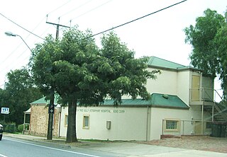
Tea Tree Gully (TTG) is a suburb in the greater Adelaide, South Australia area, under the City of Tea Tree Gully. Tea Tree Gully is in the City of Tea Tree Gully local government area, the South Australian House of Assembly electoral district of Newland and the Australian House of Representatives Division of Makin.

The City of Tea Tree Gully is a local council in the Australian state of South Australia, in the outer north-eastern suburbs of Adelaide. The major business district in the city is at Modbury, where Westfield Tea Tree Plaza, the Civic Centre and the library are located.

Adelaide Hills Council is a local government area in the Adelaide Hills of South Australia. It is in the hills east of Adelaide, the capital of South Australia, and extends from the South Para Reservoir in the north to the Mount Bold Reservoir in the south.

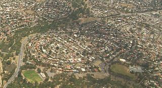
Para Hills is a residential suburb of Adelaide, South Australia. There is a light aircraft airport close to its boundary, and numerous sporting facilities, abundant parks and schools and two medium-sized shopping centres. Most of the suburb is in the City of Salisbury while some is in the City of Tea Tree Gully.

Gulfview Heights is a small suburb of Adelaide, South Australia and is within the City of Salisbury and City of Tea Tree Gully local government area. It is adjacent to Wynn Vale, Salisbury East and Para Hills.
Wynn Vale is an outer north-eastern suburb of Adelaide, South Australia and is located within the City of Tea Tree Gully local government area. It is adjacent to Golden Grove, Modbury Heights, Surrey Downs, Salisbury East and Para Hills. It is located approximately 20 km north-east of the city of Adelaide.
Carey Gully is a small town in the Adelaide Hills region of South Australia.
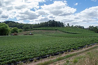
McLaren Flat is a township in the McLaren Vale/Willunga basin south of Adelaide. McLaren Flat is on the sprawling flat land to the east of the town of McLaren Vale on the road to Kangarilla. At the 2016 census, the locality had a population of 1,537 of which 1,121 lived in its town centre.

Houghton is a small town near Adelaide, South Australia. It is located in the Adelaide Hills, in the City of Tea Tree Gully and the Adelaide Hills Council local government areas between Tea Tree Gully and Inglewood on the North East Road.
Yatala Vale is an outer northeastern rural suburb of Adelaide, South Australia. It is located in the City of Tea Tree Gully local government area, and is adjacent to Golden Grove and Fairview Park, as well as the rural districts of Upper Hermitage and Gould Creek.
Gould Creek is an outer northeastern rural suburb of Adelaide, South Australia. Gould Creek is located in the City of Tea Tree Gully and City of Playford local government areas, and is adjacent to Greenwith, Salisbury Heights and Hillbank, as well as the rural districts of Yatala Vale and Upper Hermitage and the town of One Tree Hill.
Redwood Park is a suburb in the northeastern suburbs of Adelaide, South Australia.

Kangarilla is a small rural town and locality around 33 km (21 mi) from Adelaide city centre, in South Australia. The area, formerly inhabited by Kaurna people, was settled by Europeans in 1840, not long after the British colonisation of South Australia. Today it lies within the City of Onkaparinga local government area, and has postcode 5157. At the 2016 census, Kangarilla had a population of 896.

Anstey Hill Recreation Park is a 362-hectare (890-acre) protected area established in 1989 and located approximately 19 kilometres (12 mi) northeast of Adelaide, South Australia. The park is a significant reserve of bushland in the foothills of the Mount Lofty Ranges and is home to rare or vulnerable native plants and animals, and problematic invasive species. It is managed by the City of Tea Tree Gully, the Department of Environment, Water and Natural Resources and a volunteer group—The Friends of Anstey Hill. The park is designed for recreational walking and has no visitor facilities. It is managed in association with the regional planning initiative known as of Yurrebilla, the Greater Mount Lofty Parklands.
Golden Grove is an outer north-eastern suburb of Adelaide, South Australia and is within the City of Tea Tree Gully local government area. It is adjacent to Wynn Vale, Surrey Downs, Greenwith, Yatala Vale, Fairview Park, and Salisbury East.
Sampson Flat is a locality northeast of Adelaide, South Australia in the City of Playford. It used to be known as Sampson's Flat. The area drains to the west into the Little Para Reservoir. It is a mixture of open pasture with scattered trees, and denser scrub on the higher eastern side.
The District Council of Yatala was a local government area of South Australia established in 1853 and abolished in 1868.

Dry Creek or Dry Creek Drain is a seasonal stream in South Australia which passes through the Adelaide suburbs of Modbury, Walkley Heights and Pooraka. The nearby suburb of Dry Creek and Dry Creek railway station are named after the stream.

The 2015 Sampson Flat fires were a series of bushfires in the Australian state of South Australia, the area affected was predominantly the northern Adelaide Hills and the outer Adelaide metropolitan area. The fire began on 2 January 2015 during a day of extreme heat and lasted until 9 January 2015; and burnt more than 20,000 hectares.

The Hundred of Yatala is a cadastral unit of hundred in South Australia covering much of the Adelaide metropolitan area north of the River Torrens. It is one of the eleven hundreds of the County of Adelaide stretching from the Torrens in the south to the Little Para River in the north; and spanning from the coast in the west to the Adelaide foothills in the east. It is roughly bisected from east to west by Dry Creek. It was named in 1846 by Governor Frederick Robe, Yatala being likely derived from yartala, a Kaurna word referring to the flooded state of the plain either side of Dry Creek after heavy rain.
