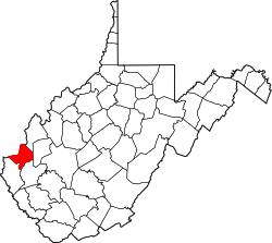
Yates Crossing, West Virginia | |
---|---|
Coordinates: 38°26′29.31″N82°11′23.52″W / 38.4414750°N 82.1898667°W | |
Country | United States |
State | West Virginia |
County | Cabell |
Elevation | 584 ft (178 m) |
Time zone | UTC-5 (Eastern (EST)) |
• Summer (DST) | UTC-4 (EDT) |
ZIP codes | 25701 |
GNIS ID | 1549445 [1] |
Yates Crossing is an unincorporated community in Cabell County, West Virginia, United States. [2]
Yates County is a county in the U.S. state of New York. As of the 2020 Census, the population was 24,774, making it the third-least populous county in New York. The county seat is Penn Yan. The name is in honor of Joseph C. Yates, who as Governor of New York signed the act establishing the county. The county is part of the Finger Lakes region of the state.
Warsaw is a home rule-class city in and the county seat of Gallatin County, Kentucky, United States, located along the Ohio River. The name was suggested by a riverboat captain, who was reading Thaddeus of Warsaw, by Jane Porter, when the city was being founded.
The Virginian Railway was a Class I railroad located in Virginia and West Virginia in the United States. The VGN was created to transport high quality "smokeless" bituminous coal from southern West Virginia to port at Hampton Roads.
Yates may refer to:
The National Register of Historic Places in the United States is a register including buildings, sites, structures, districts, and objects. The Register automatically includes all National Historic Landmarks as well as all historic areas administered by the U.S. National Park Service. Since its introduction in 1966, more than 97,000 separate listings have been added to the register.
West Virginia Route 28 is a north–south route through the Potomac Highlands of the U.S. state of West Virginia. The southern terminus of the route is at West Virginia Route 39 in Huntersville. The northern terminus is at the Maryland state line in Wiley Ford, where the route continues into Cumberland as Canal Parkway upon crossing the North Branch Potomac River.
New York State Route 230 (NY 230) is a state highway in the Finger Lakes region of New York in the United States. NY 230 is an east–west highway between the eastern edge of Steuben County to the interior of adjacent Yates County. The western terminus of NY 230 is the community of Keuka in the town of Wayne on the edge of Keuka Lake at NY 54. The eastern terminus is at its junction with NY 14A in the town of Barrington, west of the village of Dundee.
State Route 49 is a primary state highway in the U.S. state of Virginia. The state highway runs 69.01 miles (111.06 km) from the North Carolina state line in Virgilina, Virginia in Halifax County, where the highway continues south as North Carolina Highway 49, north to U.S. Route 360 near Burkeville in Nottoway County. SR 49 passes through Southside Virginia, connecting Virgilina and Burkeville with Clarksville and Chase City in Mecklenburg County, Victoria in Lunenburg County, and Crewe in Nottoway County. Via US 360, the state highway connects Richmond with the John H. Kerr Reservoir.
U.S. Route 60 (US 60) in the Commonwealth of Virginia runs 303 miles (488 km) west to east through the central part of the state, generally close to and paralleling the Interstate 64 corridor, except for the crossing of the Blue Ridge Mountains, and in the South Hampton Roads area.
The Great Indian Warpath (GIW)—also known as the Great Indian War and Trading Path, or the Seneca Trail—was that part of the network of trails in eastern North America developed and used by Native Americans which ran through the Great Appalachian Valley. The system of footpaths extended from what is now upper New York to deep within Alabama. Various Native peoples traded and made war along the trails, including the Catawba, numerous Algonquian tribes, the Cherokee, and the Iroquois Confederacy. The British traders' name for the route was derived from combining its name among the northeastern Algonquian tribes, Mishimayagat or "Great Trail", with that of the Shawnee and Delaware, Athawominee or "Path where they go armed".
State Route 645 in Fairfax County, Virginia is a secondary state highway. There are six portions, three of them being major, named Wall Road, Lees Corner Road, Stringfellow Road, Clifton Road, Main Street and Burke Lake Road. There are also numerous overlaps : some include SR 657 / Centreville Road, U.S. Route 50, SR 652, SR 612, and SR 641. A concurrency used to exist at US 29 near Centreville until the 1990s.
Lynton Yates Ballentine was a North Carolina politician who served as the 20th Lieutenant Governor of North Carolina from 1945 to 1949 and as the 12th North Carolina Commissioner of Agriculture from 1949 until his death on July 19, 1964.
Iron Acton station opened on 2 September 1872, with the start of services on the Midland Railway branch from Yate to Thornbury. The station was designed by the Midland Railway company architect John Holloway Sanders.
John Yates Beall was a Confederate privateer in the American Civil War who was arrested as a spy in New York and executed at Fort Columbus on Governors Island.
State Route 612 in Fairfax and Prince William counties, Virginia, is a secondary state highway. The two counties are separated by water, so SR 612 contains a bridge that is one of only eight crossings between the counties. Because of this, SR 612 is heavily traveled during rush hour.
William Yates, was a clergyman in the Church of England, educator, fifth president of the College of William & Mary and is the namesake for Yates Hall on the College's campus.
Yates is a former unincorporated community in Taylor County, West Virginia. The site is now underwater in Tygart Lake, having been inundated after construction of the Tygart Dam (1934–38).
Yates Tavern, also known as Yancy Cabin, is a historic tavern located near Gretna, Pittsylvania County, Virginia. The building dates to the late-18th or early-19th century, and is a two-story, frame building sheathed in weatherboard. It measures approximately 18 feet by 24 feet and has eight-inch jetty on each long side at the second-floor level. It is representative of a traditional hall-and-parlor Tidewater house. The building was occupied by a tavern in the early-19th century. It was restored in the 1970s.