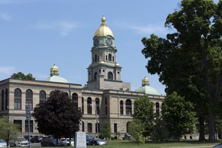
Cabell County is a county located in the U.S. state of West Virginia. As of the 2020 census, the population was 94,350, making it West Virginia's fourth most-populous county. Its county seat is Huntington. The county was organized in 1809 and named for William H. Cabell, the Governor of Virginia from 1805 to 1808. Cabell County is part of the Huntington–Ashland, WV–KY–OH Metropolitan Statistical Area.
Newport News is an independent city in southeastern Virginia, United States. At the 2020 census, the population was 186,247. Located in the Hampton Roads region, it is the fifth-most populous city in Virginia and 140th-most populous city in the United States. The city is at the southeastern end of the Virginia Peninsula, on the northern shore of the James River to the river's mouth on the harbor of Hampton Roads.

Interstate 64 (I-64) is an east–west Interstate Highway in the Eastern United States. Its western terminus is at I-70, U.S. Route 40 (US 40), and US 61 in Wentzville, Missouri. Its eastern terminus is at the Bowers Hill Interchange with I-264 and I-664 at Bower's Hill in Chesapeake, Virginia. I-64 connects Greater St. Louis, the Louisville metropolitan area, the Lexington–Fayette metropolitan area, the Charleston metropolitan area, the Greater Richmond Region, and Hampton Roads.

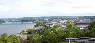
Huntington is a city in Cabell and Wayne counties in the U.S. state of West Virginia. The seat of Cabell County, the city is located in SW West Virginia at the confluence of the Ohio and Guyandotte rivers. Huntington is the second-most populous city in West Virginia, with a population of 46,842 as of the 2020 census. Its metro area, the Huntington–Ashland metropolitan area, is the largest in West Virginia, spanning seven counties across three states and having a population of 376,155 at the 2020 census.

Burlington is an unincorporated community and census-designated place in Lawrence County, Ohio, United States, along the Ohio River. The population was 2,416 at the 2020 census. Connected to neighboring Huntington, West Virginia and connected via the West Huntington Bridge over the Ohio River, it is part of the Huntington–Ashland metropolitan area. Burlington was once the leading community of Lawrence County, being the first county seat and the location of the county's first post office. “The Memory Man” by David Baldacci takes place in Burlington. The main character is Amos Decker. There are 7 books in this series.
Parkersburg is a city in and the county seat of Wood County, West Virginia, United States. Located at the confluence of the Ohio and Little Kanawha rivers, it is the state's fourth-most populous city and the center of the Parkersburg–Vienna metropolitan area. The city's population was 29,749 at the 2020 census, and its metro population was 89,490. The city is about 14 miles (23 km) south of Marietta, Ohio.

The James River is a river in Virginia that begins in the Appalachian Mountains and flows from the confluence of the Cowpasture and Jackson Rivers in Botetourt County 348 miles (560 km) to the Chesapeake Bay. The river length extends to 444 miles (715 km) if the Jackson River is included, the longer of its two headwaters. It is the longest river in Virginia. Jamestown and Williamsburg, Virginia's first colonial capitals, and Richmond, Virginia's current capital, lie on the James River.
The Huntington Library, Art Museum and Botanical Gardens, known as The Huntington, is a collections-based educational and research institution established by Henry E. Huntington and Arabella Huntington in San Marino, California, United States. In addition to the library, the institution houses an extensive art collection with a focus on 18th and 19th century European art and 17th to mid-20th century American art. The property also has approximately 120 acres (49 ha) of specialized botanical landscaped gardens, including the "Japanese Garden", the "Desert Garden", and the "Chinese Garden".

Collis Potter Huntington was an American industrialist and railway magnate. He was one of the Big Four of western railroading who invested in Theodore Judah's idea to build the Central Pacific Railroad as part of the first U.S. transcontinental railroad. Huntington helped lead and develop other major interstate lines, such as the Southern Pacific Railroad and the Chesapeake & Ohio Railway (C&O), which he was recruited to help complete. The C&O, completed in 1873, fulfilled a long-held dream of Virginians of a rail link from the James River at Richmond to the Ohio River Valley. The new railroad facilities adjacent to the river there resulted in expansion of the former small town of Guyandotte, West Virginia into part of a new city which was named Huntington in his honor.

U.S. Route 52 (US 52) is a major United States highway in the central United States that extends from the northern to southeastern region of the United States. Contrary to most other even-numbered U.S. Highways, US 52 primarily follows a northwest–southeast route, and is signed north–south or east–west depending on the local orientation of the route. The highway's northwestern terminus is in Portal, North Dakota at the Canada–United States border, where it continues as Saskatchewan Highway 39. Its southeastern terminus is in Charleston, South Carolina, at Number 2 Meeting Street and White Point Garden along the Charleston Harbor.

State Route 7 (SR 7), formerly known as Inter-county Highway 7 until 1921 and State Highway 7 in 1922, is a north–south state highway in the southern and eastern portions of the U.S. state of Ohio. At about 336 miles (541 km) in length, it is the longest state route in Ohio. Its southern terminus is an interchange with U.S. Route 52 (US 52) just west of Chesapeake. Its northern terminus also serves as the eastern terminus of SR 531 in Conneaut. The path of SR 7 stays within five miles (8.0 km) of the Ohio River for the southern portion, with the river being visible from much of the route. The road also remains within 10 miles (16 km) of the Pennsylvania state line for the northern portion.

West Virginia Route 527 is a north–south state highway located entirely in Huntington, West Virginia. The southern terminus of the route is at Interstate 64 exit 8, where WV 527 becomes West Virginia Route 152 upon crossing the expressway. The northern terminus is on the West Virginia Department of Transportation-maintained Robert C. Byrd Bridge, better known as the Sixth Street Bridge, where the route becomes State Route 527 upon crossing into Ohio. In Ohio, SR 527 continues northward to State Route 7 in Chesapeake.
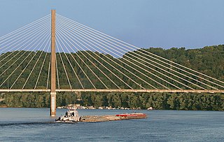
The East Huntington Bridge is a 900-foot (270 m) cable-stayed bridge crossing the Ohio River at Huntington, West Virginia. It carries West Virginia Route 106 on the West Virginia approach and OH 775 on the Ohio approach.
U.S. Route 52 (US 52) skirts the western fringes of the U.S. state of West Virginia. It runs from the Virginia state line near Bluefield, where it is concurrent with Interstate 77 (I-77), in a general northwest and north direction to I-64 at Kenova. There it turns east, overlapping I-64 for five miles (8.0 km) before splitting off onto the West Huntington Expressway into Ohio via the West Huntington Bridge. Despite having an even number, US 52 is signed north–south in West Virginia. In some other states along its route, it is signed east-west. The West Virginia segment is signed such that US 52 north corresponds to the general westward direction of the highway, and vice versa. For a while, US 52 parallels US 23, which is on the other side of the Big Sandy River in Kentucky. This continues into Ohio, where US 52 travels on the Ohio side of the Ohio River while US 23 travels on the Kentucky side.
The Charleston Metropolitan Statistical Area, as defined by the United States Census Bureau, is an area consisting of three counties in West Virginia, anchored by the city of Charleston. It is the largest metropolitan area entirely within the state of West Virginia. The Huntington Metro Area adds to the Charleston–Huntington, WV-OH-KY CSA and spans three states, while the core county of the Charleston area, Kanawha County, is more populous than the West Virginia portion of the Huntington area.
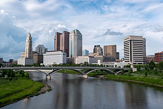
The Columbus, Ohio metropolitan area is a metropolitan area in Central Ohio surrounding the state capital of Columbus. As defined by the U.S. Census Bureau, it includes the counties of Delaware, Fairfield, Franklin, Hocking, Licking, Madison, Morrow, Perry, Pickaway, and Union. At the 2020 census, the MSA had a population of 2,138,926, making it 32nd-most populous in the United States and the second largest in Ohio, behind the Cincinnati metropolitan area. The metro area, also known as Central Ohio or Greater Columbus, is one of the largest and fastest-growing metropolitan areas in the Midwestern United States.
Huntington is home to dozens of parks located in the neighborhoods of Huntington. An amusement park is also adjacent to the city.
The Huntington–Ashland metropolitan area is a metropolitan area in the Appalachian Plateau region of the United States. Referred to locally as the "Tri-State area," and colloquially as "Kyova", the region spans seven counties in the three states of Kentucky, Ohio, and West Virginia. With a population of 361,580, the Tri-State area is nestled along the banks of the Ohio River. The region offers a diverse range of outdoor activities.

St. Cloud Commons is a public park, managed by the Greater Huntington Park and Recreation District in Huntington, West Virginia.
The following is a timeline of the history of the city of Huntington, West Virginia, USA.


