Belmont Park, Huntington, West Virginia

Last updated

Belmont Park, West Virginia
USA West Virginia location map.svg
Red pog.svg
Belmont Park
Location within the state of West Virginia
Usa edcp location map.svg
Red pog.svg
Belmont Park
Belmont Park (the United States)
Coordinates: 38°23′37.30″N82°23′36.55″W / 38.3936944°N 82.3934861°W / 38.3936944; -82.3934861
Country United States
State West Virginia
County Cabell
City Huntington
Elevation
801 ft (244 m)
Time zone UTC-5 (Eastern (EST))
  Summer (DST) UTC-4 (EDT)
ZIP codes
25701
GNIS ID 1740342 [1]

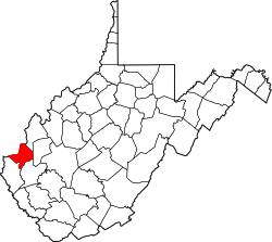
Belmont Park is an unincorporated community in Huntington, Cabell County, West Virginia, United States.

See also

Related Research Articles

Belmont may refer to:

<span class="mw-page-title-main">Cabell County, West Virginia</span> County in West Virginia, United States

Cabell County is a county located in the U.S. state of West Virginia. As of the 2020 census, the population was 94,350, making it West Virginia's fourth most-populous county. Its county seat is Huntington. The county was organized in 1809 and named for William H. Cabell, the Governor of Virginia from 1805 to 1808. Cabell County is part of the Huntington–Ashland, WV–KY–OH Metropolitan Statistical Area.

<span class="mw-page-title-main">Huntington, West Virginia</span> City in West Virginia, United States

Huntington is a city in Cabell and Wayne counties in the U.S. state of West Virginia. The seat of Cabell County, the city is located at the confluence of the Ohio and Guyandotte rivers. Huntington is the second-most populous city in West Virginia, with a population of 46,842 as of the 2020 census. Its metro area, the Huntington–Ashland metropolitan area, is the largest in West Virginia, spanning seven counties across three states and having a population of 376,155 at the 2020 census.

<span class="mw-page-title-main">Collis Potter Huntington</span> American railroad magnate (1821–1900)

Collis Potter Huntington was an American industrialist and railway magnate. He was one of the Big Four of western railroading who invested in Theodore Judah's idea to build the Central Pacific Railroad as part of the first U.S. transcontinental railroad. Huntington helped lead and develop other major interstate lines, such as the Southern Pacific Railroad and the Chesapeake & Ohio Railway (C&O), which he was recruited to help complete. The C&O, completed in 1873, fulfilled a long-held dream of Virginians of a rail link from the James River at Richmond to the Ohio River Valley. The new railroad facilities adjacent to the river there resulted in expansion of the former small town of Guyandotte, West Virginia into part of a new city which was named Huntington in his honor.

<span class="mw-page-title-main">Massachusetts Route 9</span> East-west state highway in Massachusetts, US

Route 9 is a 135.310-mile-long (217.760 km) major east–west state highway in Massachusetts, United States. Along with U.S. Route 20, Route 2, and Interstate 90, Route 9 is one of the major east–west routes of Massachusetts. The western terminus is near the center of the city of Pittsfield. After winding through the small towns along the passes of the Berkshire Mountains, it crosses the college towns of the Pioneer Valley and then south of the Quabbin Reservoir and the rural areas of western Worcester County. Entering the city of Worcester from the southwestern corner of the city, it passes through the center of the city and forms the major commercial thoroughfare through the MetroWest suburbs of Boston, parallel to the Massachusetts Turnpike. Crossing the Route 128 freeway circling Boston, it passes through the inner suburbs of Newton and Brookline along Boylston Street, and enters Boston on Huntington Avenue, before reaching its eastern terminus at Copley Square.

<span class="mw-page-title-main">Ohio State Route 7</span> State highway in Ohio, US

State Route 7 (SR 7), formerly known as Inter-county Highway 7 until 1921 and State Highway 7 in 1922, is a north–south state highway in the southern and eastern portions of the U.S. state of Ohio. At about 336 miles (541 km) in length, it is the longest state route in Ohio. Its southern terminus is an interchange with U.S. Route 52 (US 52) just west of Chesapeake. Its northern terminus also serves as the eastern terminus of SR 531 in Conneaut. The path of SR 7 stays within five miles (8.0 km) of the Ohio River for the southern portion, with the river being visible from much of the route. The road also remains within 10 miles (16 km) of the Pennsylvania state line for the northern portion.

Lansdowne is a census-designated place and planned community located near Leesburg, Virginia in Loudoun County, Virginia. The population as of the 2010 United States Census was 11,253. It is north of State Route 7 and south of the Potomac River. Before the Revolutionary War, the Lee family established Coton Manor here. A section of the Potomac Heritage Trail runs through Lansdowne. It is the home of Inova Loudoun Hospital, the Jack Kent Cooke Foundation, Lansdowne Resort, Prison Fellowship, and Lansdowne Woods of Virginia, a gated, age-restricted community.

<span class="mw-page-title-main">Pink Bridge</span> Bridge in Huntington, West Virginia

The Pink Bridge of Huntington, West Virginia is a concrete arch bridge spanning Four Pole Creek at 8th Street that was painted pink during late October to mid November 2006 to raise awareness of breast cancer.

The Huntington–Ashland metropolitan area is a metropolitan area in the Appalachian Plateau region of the United States. Referred to locally as the "Tri-State area," and colloquially as "Kyova", the region spans seven counties in the three states of Kentucky, Ohio, and West Virginia. With a population of 361,580, the Tri-State area is nestled along the banks of the Ohio River. The region offers a diverse range of outdoor activities.

<span class="mw-page-title-main">Will E. Neal</span> American politician

William Elmer Neal was a physician and U.S. Representative from West Virginia.

Belmont is a Roanoke, Virginia neighborhood located in southeast Roanoke. It borders the neighborhoods of Hollins and Williamson Road on the north, Morningside and South Jefferson to the south, Downtown on the west and Fallon on the east. Today the neighborhood is bisected by Virginia State Route 24 and is bordered by Interstate 581 to the west.

<span class="mw-page-title-main">National Register of Historic Places listings in Belmont County, Ohio</span>

This is a list of the National Register of Historic Places listings in Belmont County, Ohio.

<span class="mw-page-title-main">National Register of Historic Places listings in Cabell County, West Virginia</span>

This is a list of the National Register of Historic Places listings in Cabell County, West Virginia.

<span class="mw-page-title-main">United States Post Office and Court House (Huntington, West Virginia)</span> United States historic place

The United States Post Office and Court House in Huntington, West Virginia is a federal building housing the United States District Court for the Southern District of West Virginia. It was built in 1907 and expanded in 1907, and again in 1937. The original construction was the result of the Tarsney Act of 1893. The federal courthouse is part of a group of significant civic structures in the center of Huntington that includes the Cabell County Courthouse, the Huntington City Hall and the Carnegie Public Library. The original design was by Parker and Thomas of Boston and Baltimore. The post office has since been moved to another location. In 1980, the United States Congress passed legislation renaming the building the Sidney L. Christie Federal Building, in honor of District Court judge Sidney Lee Christie.

Bells Crossroad is an unincorporated community in Spotsylvania County, in the U.S. state of Virginia. This community is centered on the intersection of Stubbs Bridge Road and Lawyer's Road.

Belmont is an unincorporated community in Spotsylvania County, in the U.S. state of Virginia. It is marked with a highway sign at the intersection of Belmont Road and Orange Springs Road by the Virginia Department of Transportation, however is marked as being the intersection with Belmont Road and Jones Powell Road by the United States Geological Survey (USGS). The immediate area has Fletcher's Store and the Belmont Christmas Tree farm. Further south, there are other buildings identifying with Belmont, such as Belmont Baptist Church, the Belmont Ruritan Community Building where the Belmont Ruritan Club meets each evening at 7 p.m. and serves as the district's polling place for registered voters, and the Belmont Fire & Rescue station staffed by Spotsylvania County Volunteer Company 9.

<span class="mw-page-title-main">Downtown Huntington Historic District</span> US national historic district in West Virginia

Downtown Huntington Historic District is a national historic district located at Huntington, Cabell County, West Virginia. The original district encompassed 59 contributing buildings; the boundary increase added 53 more contributing buildings. It includes the central business district of Huntington and includes several of its municipal and governmental buildings. It contains the majority of the historic concentration of downtown commercial buildings. Located in the district are the separately listed Carnegie Public Library, Cabell County Courthouse, U.S. Post Office and Court House, and Campbell-Hicks House.

<span class="mw-page-title-main">National Register of Historic Places listings in Braxton County, West Virginia</span>

This is a list of the National Register of Historic Places listings in Braxton County, West Virginia.

The following is a timeline of the history of the city of Huntington, West Virginia, USA.

<span class="mw-page-title-main">Elmont–UBS Arena station</span> Long Island Rail Road station in Nassau County, New York

Elmont–UBS Arena is a Long Island Rail Road (LIRR) station in Elmont and Bellerose Terrace, New York, just east of the Nassau County border with the New York City borough of Queens. It serves the LIRR Main Line and was built as part of the redevelopment of Belmont Park, which included the construction of the UBS Arena for the NHL's New York Islanders hockey team. The station opened for eastbound service in November 2021 and westbound service in October 2022.

References