Anita Heights, Huntington, West Virginia

Last updated

Anita Heights, West Virginia
USA West Virginia location map.svg
Red pog.svg
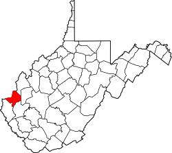
Anita Heights
Location within the state of West Virginia
Usa edcp location map.svg
Red pog.svg
Anita Heights
Anita Heights (the United States)
Coordinates: 38°24′18.30″N82°24′19.55″W / 38.4050833°N 82.4054306°W / 38.4050833; -82.4054306
Country United States
State West Virginia
County Cabell
City Huntington
Elevation
659 ft (201 m)
Time zone UTC-5 (Eastern (EST))
  Summer (DST) UTC-4 (EDT)
ZIP codes
25701
GNIS ID 1740340 [1]

Anita Heights is an unincorporated community in Huntington, Cabell County, West Virginia, United States.

See also

Related Research Articles

<span class="mw-page-title-main">Cabell County, West Virginia</span> County in West Virginia, United States

Cabell County is a county located in the U.S. state of West Virginia. As of the 2020 census, the population was 94,350, making it West Virginia's fourth most-populous county. Its county seat is Huntington. The county was organized in 1809 and named for William H. Cabell, the Governor of Virginia from 1805 to 1808. Cabell County is part of the Huntington–Ashland, WV–KY–OH Metropolitan Statistical Area.

<span class="mw-page-title-main">Huntington, West Virginia</span> City in West Virginia, United States

Huntington is a city in Cabell and Wayne counties in the U.S. state of West Virginia. The seat of Cabell County, the city is located at the confluence of the Ohio and Guyandotte rivers. Huntington is the second-most populous city in West Virginia, with a population of 46,842 as of the 2020 census. Its metro area, the Huntington–Ashland metropolitan area, is the largest in West Virginia, spanning seven counties across three states and having a population of 376,155 at the 2020 census.

<span class="mw-page-title-main">Henry E. Huntington</span> American railroad magnate (1850–1927)

Henry Edwards Huntington was an American railroad magnate and collector of art and rare books. Huntington settled in Los Angeles, where he owned the Pacific Electric Railway as well as substantial real estate interests. In addition to being a businessman and art collector, Huntington was a major booster for Los Angeles in the late 19th and early 20th centuries. Many places in California are named after him.

<span class="mw-page-title-main">Collis Potter Huntington</span> American railroad magnate (1821–1900)

Collis Potter Huntington was an American industrialist and railway magnate. He was one of the Big Four of western railroading who invested in Theodore Judah's idea to build the Central Pacific Railroad as part of the first U.S. transcontinental railroad. Huntington helped lead and develop other major interstate lines, such as the Southern Pacific Railroad and the Chesapeake & Ohio Railway (C&O), which he was recruited to help complete. The C&O, completed in 1873, fulfilled a long-held dream of Virginians of a rail link from the James River at Richmond to the Ohio River Valley. The new railroad facilities adjacent to the river there resulted in expansion of the former small town of Guyandotte, West Virginia into part of a new city which was named Huntington in his honor.

<span class="mw-page-title-main">U.S. Route 52</span> Highway in the United States

U.S. Route 52 (US 52) is a major United States highway in the central United States that extends from the northern to southeastern region of the United States. Contrary to most other even-numbered U.S. Highways, US 52 primarily follows a northwest–southeast route, and is signed north–south or east–west depending on the local orientation of the route. The highway's northwestern terminus is in Portal, North Dakota at the Canada–United States border, where it continues as Saskatchewan Highway 39. Its southeastern terminus is in Charleston, South Carolina, at Number 2 Meeting Street and White Point Garden along the Charleston Harbor.

<span class="mw-page-title-main">Chesapeake and Ohio Railway</span> Defunct American Class I railway

The Chesapeake and Ohio Railway was a Class I railroad formed in 1869 in Virginia from several smaller Virginia railroads begun in the 19th century. Led by industrialist Collis P. Huntington, it reached from Virginia's capital city of Richmond to the Ohio River by 1873, where the railroad town of Huntington, West Virginia, was named for him.

<span class="mw-page-title-main">WOWK-TV</span> CBS affiliate in Huntington, West Virginia

WOWK-TV is a television station licensed to Huntington, West Virginia, United States, serving the Charleston–Huntington market as an affiliate of CBS. Owned by Nexstar Media Group, the station maintains studios on Quarrier Street near the Charleston Town Center in downtown Charleston, and its transmitter is located in Milton, West Virginia.

<span class="mw-page-title-main">WKEE-FM</span> Radio station in Huntington, West Virginia

WKEE-FM is a contemporary hit radio formatted broadcast radio station licensed to Huntington, West Virginia, serving Huntington, West Virginia, Ashland, Kentucky, and Ironton, Ohio. WKEE-FM is owned and operated by iHeartMedia. WKEE-FM is the heritage CHR/Top 40 station in the Huntington area, having programmed hit music as a standalone FM for over 30 years.

<span class="mw-page-title-main">U.S. Route 52 in West Virginia</span> Section of U.S. highway in West Virginia

U.S. Route 52 (US 52) skirts the western fringes of the U.S. state of West Virginia. It runs from the Virginia state line near Bluefield, where it is concurrent with Interstate 77 (I-77), in a general northwest and north direction to I-64 at Kenova. There it turns east, overlapping I-64 for five miles (8.0 km) before splitting off onto the West Huntington Expressway into Ohio via the West Huntington Bridge. Despite having an even number, US 52 is signed north–south in West Virginia. In some other states along its route, it is signed east-west. The West Virginia segment is signed such that US 52 north corresponds to the general westward direction of the highway, and vice versa. For a while, US 52 parallels US 23, which is on the other side of the Big Sandy River in Kentucky. This continues into Ohio, where US 52 travels on the Ohio side of the Ohio River while US 23 travels on the Kentucky side.

<span class="mw-page-title-main">East Lynn Lake</span> State Wildlife Management Area in Wayne County, West Virginia

East Lynn Lake is a 1,005-acre (4 km2) reservoir on the East Fork Twelvepole Creek in Wayne County, West Virginia. The lake is operated by the U.S. Army Corps of Engineers, Huntington District, as part of a series of flood control projects for the Ohio River basin.

The Huntington–Ashland metropolitan area is a metropolitan area in the Appalachian Plateau region of the United States. Referred to locally as the "Tri-State area," and colloquially as "Kyova", the region spans seven counties in the three states of Kentucky, Ohio, and West Virginia. With a population of 361,580, the Tri-State area is nestled along the banks of the Ohio River. The region offers a diverse range of outdoor activities.

<span class="mw-page-title-main">Will E. Neal</span> American politician

William Elmer Neal was a physician and U.S. Representative from West Virginia.

<span class="mw-page-title-main">West Virginia Colored Children's Home</span> United States historic place

The West Virginia Colored Children's Home was a historic school, orphanage, and sanatorium building located near Huntington, Cabell County, West Virginia. It was the state's first social institution exclusively serving the needs of African American residents. The main structure, built in 1922–1923, was a three-story red brick building in the Classical Revival style. That building, located at 3353 U.S. Route 60, Huntington, West Virginia, was the last of a series of buildings that were constructed on the site. It was also known as the West Virginia Colored Orphans Home, Colored Orphan Home and Industrial School, the West Virginia Home for Aged and Infirm Colored Men and Women, and University Heights Apartments. It was listed on the National Register of Historic Places in 1997 but was demolished in 2011.

Paul Thomas Farrell Jr. is an American attorney from Huntington, West Virginia who ran for President of the United States in the 2016 West Virginia Democratic primary.

<span class="mw-page-title-main">Huntington Drive</span> United States street in Los Angeles

Huntington Drive is a major thoroughfare that begins in the Rose Hills community in Los Angeles, California and heads east/northeast to Irwindale, California. The street was named after railroad magnate Henry E. Huntington. It also served as one of the only thoroughfares between Los Angeles and Pasadena in the early 1900s. Portions of Huntington Drive were part of U.S. Route 66. The road has a wide median that was originally one of the lines of the Pacific Electric Railway, the Monrovia–Glendora Line.

Grandview Heights is an unincorporated community in Huntington, Cabell County, West Virginia, United States.

References