
The Satpura Range is a range of hills in central India. The range rises in eastern Gujarat running east through the border of Maharashtra and Madhya Pradesh and ends in Chhattisgarh. The range parallels the Vindhya Range to the north, and these two east–west ranges divide Indian Subcontinent into the Indo-Gangetic plain of northern India and the Deccan Plateau of the south. The Narmada River originates from north-eastern end of Satpura in Amarkantak, and runs in the depression between the Satpura and Vindhya ranges, draining the northern slope of the Satpura range, running west towards the Arabian Sea. The Tapti River originates in the eastern-central part of Satpura, crossing the range in the center and running west at the range's southern slopes before meeting the Arabian Sea at Surat, draining the central and southern slopes of the range. Multai, the place of Tapi river origin is located about 465 kilometer far, south-westerly to Amarkantak, separated across by the hill range. The Godavari River and its tributaries drain the Deccan plateau, which lies south of the range, and the Mahanadi River drains the easternmost portion of the range. The Godavari and Mahanadi rivers flow into the Bay of Bengal. At its eastern end, the Satpura range meets the hills of the Chotanagpur Plateau. The Satpura Range is a horst mountain and is flanked by Narmada Graben in the north and much smaller but parallel Tapi Graben in the south.
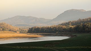
Satpura Tiger Reserve (STR) also known as Satpura National Park is located in the Narmadapuram district of Madhya Pradesh in India. Its name is derived from the Satpura range. It covers an area of 524 km2 (202 sq mi). Satpura National Park, along with the adjoining Bori and Pachmarhi wildlife sanctuaries, provides 2,200 km2 (850 sq mi) of unique central Indian highland ecosystem. It was set up in 1981.

Bondla Wildlife Sanctuary is located in northeastern Goa, India in Ponda taluka. The total area of the park is 8 km2. It is a popular destination for both tourists and schoolchildren. A wide variety of animal life can be encountered, including: sambar deer, Indian bison, Malabar giant squirrel, Indian peafowl and many species of snakes.

Kali Tiger Reserve is a protected area and tiger reserve. It is located in Uttara Kannada district, in Karnataka, India. The park is a habitat of Bengal tigers, black panthers and Indian elephants, amongst other distinctive fauna. The Kali River flows through the tiger reserve and is the lifeline of the ecosystem and hence the name. The tiger reserve is spread over an area of 1300 square kilometres.

Vansda National Park, also known as Bansda National Park, is a protected area which represents the thick woodlands of the Dangs and southern Gujarat, and is situated in the Vansda tehsil, Navsari District of Gujarat state, India. Riding on the banks of Ambika River and measuring roughly 24 km2 in area, the park lies about 65 km east of the town of Chikhali on the National Highway 48, and about 80 km northeast of the city of Valsad. Vansda, the town from which the name of the park is derived, is an important trading place for the surrounding area where the majority of the population is represented by adivasis. Vansda-Waghai state highway runs through the park, so does the narrow gauge rail link connecting Waghai to Billimora.

Bhadra Wildlife Sanctuary is a protected area and tiger reserve as part of the Project Tiger, situated in Chikkamagaluru district, 23 km (14 mi) south of Bhadravathi city, 38 km (24 mi) 20 km from Tarikere town, northwest of Chikkamagaluru and 283 km from Bengaluru city in Karnataka state, India. Bhadra sanctuary has a wide range of flora and fauna and is a popular place for day outings. The 1,875 m (6,152 ft) above MSL Hebbe Giri is the highest peak in the sanctuary.
Bhimashankar Wildlife Sanctuary was created in the Ambegaon and Khed talukas of Pune District, in the Western Indian state of Maharashtra in order mainly to protect the habitat of the Indian Giant Squirrel.

The word Maharashtra, the land of the mainly Marathi-speaking people, appears to be derived from Maharashtri, an old form of Prakrit. Some believe that the word indicates that it was the land of the Mahars and the Rattas, while others consider it to be a corruption of the term 'Maha Kantara', a synonym for 'Dandakaranya'. Maharashtra is the third largest state in India after Rajasthan and Madhya Pradesh. It covers an area of 307,713 km2 and is bordered by the states of Madhya Pradesh to the north, Chhattisgarh to the east, Telangana to the southeast, Karnataka to the south and Goa to the southwest. The state of Gujarat lies to the northwest, with the Union territory of Dadra and Nagar Haveli sandwiched between the borders. Maharashtra has coastline of 720 km.The Arabian Sea makes up Maharashtra's west coast. Maharashtra consists of two major relief divisions. The plateau is a part of the Deccan tableland and the Konkan coastal strip abutting on the Arabian Sea.
Radhanagari Wildlife Sanctuary is a wildlife sanctuary and natural World Heritage Site of category ix and x since 2012, located in Kolhapur district, Maharashtra State, India. It lies at the southern end of the Sahyadri hills in the Western Ghats. It is notable as the first declared wildlife sanctuary in Maharashtra, notified in 1958, as "Dajipur Wildlife Sanctuary" and is popularly known as the "Bison Sanctuary". Indian bison or gaur with a population around 1091 in 2014, is the flagship species of the area. It was notified as Radhanagari wildlife sanctuary vide notification No. WLP/1085/CR/588/ V/F-5, Dt.16.9.1985. The area around the Sanctuary was declared as Eco sensitive zone by Govt. of India on 15 October 2020

Melghat was among the first nine tiger reserves of India to be notified in 1973 under Project Tiger. It is located at 21°26′45″N77°11′50″E in the northern part of Amravati District of Maharashtra. Melghat Wildlife Sanctuary was declared as in 1985. The Tapti River flows through the northern part of Melghat Tiger Reserve and forms the boundary of the reserve together with the Gawilghur ridge of the Satpura Range.
Bhimbandh Wildlife Sanctuary is a wildlife sanctuary in Bihar in the south-west of Munger District.

The Brahmagiri Wildlife Sanctuary is located in Kodagu District, Karnataka State, India, within the Western Ghats and about 250 km from Bangalore. The sanctuary derives its name from the highest peak of the mountain range, Brahmagiri Peak. It was declared a sanctuary on June 5, 1974.
Someshwara Wildlife Sanctuary is a protected wildlife sanctuary in the Western Ghats of Karnataka state in India. It is named after the presiding deity "Lord Someshwara" of the famed Someshwara temple located within the sanctuary. The sanctuary lies in Udupi & Shivamogga districts of Karnataka, below Agumbe. The sanctuary houses Sitanadi nature camp run by Karnataka Forest Department. Udupi to Agumbe road passes through this wildlife sanctuary. The nearest town is Hebri which is connected by bus service to Udupi, Mangaluru and Bengaluru on a daily basis.
Shoolpaneshwar Wildlife Sanctuary is a protected area in India's Gujarat state, located in the western Satpura Range south of the Narmada River and is 607.7 km2 (234.6 sq mi) large. It shares a common boundary with Madhya Pradesh and Maharashtra. It encompasses mixed dry deciduous forest, riverine forest, few pockets of moist teak forest, agricultural fields and two water reservoirs. It was established in 1982.
Gautala Autramghat Sanctuary is a protected area of Maharashtra state, India. It lies in the Satmala and Ajantha hill ranges of the Western Ghats, and administratively is in Aurangabad District and Jalgaon District. The wildlife sanctuary was established in 1986 in an existing reserved forest area.

Purna Wildlife Sanctuary is a wildlife sanctuary in the Western Ghats mountain range, in the States of Gujarat and Maharashtra, India. In the South Gujarat, it is located between Vyara, Tapi District and Ahwa, Dang District, and in Maharashtra, it is located in Nandurbar District. Apart from the Dangs' District, it is a part of the Northern Division of the Dangs' Forest.

Sitanadi Wildlife Sanctuary is located in Dhamtari District, Chhattisgarh, India. Sitanadi Wildlife Sanctuary is a famous tourist attraction which is frequented by wildlife enthusiasts throughout the year. The wildlife sanctuary was established in 1974 under Wildlife Protection Act of 1972. This sanctuary sprawls over an area of 556 km2 and has an altitude ranging between 327 and 736 m above the sea level. It is named after Sitanadi River which originates from this sanctuary and joins Mahanadi River near Deokhut. Sitanadi Wildlife Sanctuary is known for its lush green flora and rich and unique and diverse fauna and has great potential to emerge as one of the finest wildlife destinations in central India.

Mookambika Wildlife Sanctuary is a protected wildlife sanctuary in the southern state of Karnataka in India. It derives its name from the presiding deity "Goddess Mookambika" of the popular Kollur Mookambika Temple. The sanctuary lies in the Western Ghats in Udupi district of Karnataka. The sanctuary consists of an area of 274 km2 (106 sq mi) was notified in the year 1974, by the Government of Karnataka vide notification AFD.48.FWL.74 dated 17 June 1974.
The Barnawapara Wildlife Sanctuary is located in Mahasamund district. The reserve is about 100 km from Raipur and about 45 km from Mahasamund city. It was established in 1976 under the Wildlife Protection Act. The Jonk River flows through the sanctuary, which is a tributary of the Mahanadi river. The sanctuary lies 25 km to the east of Sirpur, Mahasamund which is known for its monuments, collectively known as Sirpur Group of Monuments
The AnerDam Wildlife Sanctuary is located in Shirpur talukas of Dhule district, India. The sanctuary is spread over southwestern side of Satpura hill ranges. This sanctuary is spread around the catchment area of Aner river specially above the high flood level around the Aner Dam. This sanctuary has common boundary with Yawal Wildlife Sanctuary in Jalgaon district and forest area of Khargone district in Madhyapradesh.
