
Ceduna is a town in South Australia located on the shores of Murat Bay on the west coast of Eyre Peninsula. It lies west of the junction of the Flinders and Eyre Highways around 786 km northwest of the capital Adelaide. The port town/suburb of Thevenard lies 3 km to the west on Cape Thevenard. It is in the District Council of Ceduna, the federal Division of Grey, and the state electoral district of Flinders.

Thevenard is a port town in the far west of Eyre Peninsula, South Australia. It is contiguous with the larger town of Ceduna. Its name derives from nearby Cape Thevenard, which in turn was named after Antoine-Jean-Marie Thévenard, a French admiral. In the 2021 census, Thevenard had a population of 563.
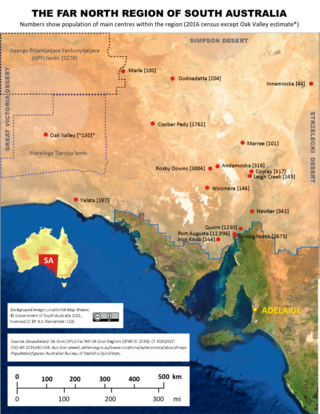
The Far North is a large region of South Australia close to the Northern Territory border. Colloquial usage of the term in South Australia refers to that part of South Australia north of a line roughly from Ceduna through Port Augusta to Broken Hill. The South Australian Government defines the Far North region similarly with the exception of the Maralinga Tjarutja Lands, the Yalata Aboriginal community and other unincorporated crown lands in the state's far west, which are officially considered part of the Eyre and Western region.

Yalata is an Aboriginal community located 200 kilometres (120 mi) west of Ceduna and 140 km (87 mi) south of Ooldea on the edge of the Nullarbor Plain in South Australia. It lies on the traditional lands of the Wirangu people, but the settlement began as Yalata Mission in the early 1950s when Pila Nguru people were moved from Ooldea Mission when that closed, after previously being moved from their land in the Great Victoria Desert owing to nuclear testing by the British Government.

Nullarbor is a locality in the Australian state of South Australia located 295 kilometres (183 mi) to the west of the town of Ceduna in the western part of the state immediately adjoining the border with Western Australia.
Denial Bay is a town and an associated locality in the Australian state of South Australia located on the state's west coast about 562 kilometres (349 mi) north-west of the state capital of Adelaide and about 10 kilometres (6.2 mi) west of the municipal seat of Ceduna.The town which is located on the western side of Murat Bay has extensive European history, first built on in 1889, and now hosts a large expanse of oyster farms, one of the largest on the Eyre Peninsula.
Fowlers Bay, formerly known as Yalata, is a bay, town and locality in the Australian state of South Australia located about 658 kilometres (409 mi) north-west of the state capital, Adelaide. The town is located on Port Eyre, at the western end of the larger Fowlers Bay. It was named Yalata after Yalata station, established in the 1860s and stretching from the Nullarbor Plain across to near Streaky Bay on the Eyre Peninsula, whose homestead was located on the hill nearby. The name Yalata now belongs to a small Aboriginal community further west, which was also situated on station land.

Nundroo is a small South Australian town, located approximately 1,014 kilometres (630 mi) west of Adelaide. It is a popular rest stop for travellers due to its location on the Eyre Highway.
Mount Finke is a monadnock in the Australian state of South Australia located in the gazetted locality of Yellabinna about 125 kilometres (78 mi) north of Ceduna.

Lincoln National Park is a locality located on the Jussieu Peninsula at the southern tip of the Eyre Peninsula in the Australian state of South Australia about 250 kilometres west of the state capital of Adelaide and about 13 kilometres south of the city of Port Lincoln.
Emeroo is a locality in the Australian state of South Australia about 295 kilometres north of the state capital of Adelaide and about 18 kilometres northeast of Port Augusta in the state’s Far North region.

Lake Gilles is a locality in the Australian state of South Australia located on the Eyre Peninsula about 278 kilometres north west of the state capital of Adelaide and about 35 kilometres to the north-east of the town of Kimba.

Flinders Ranges is a locality in the Australian state of South Australia located in the mountain range of the same name, about 380 km (240 mi) north of the state capital of Adelaide, about 86 km (53 mi) north-east of the municipal seat in Quorn and about 131 km (81 mi) north-east of the regional centre of Port Augusta.
Laura Bay is a locality in the Australian state of South Australia located on the west coast of the Eyre Peninsula overlooking the Great Australian Bight about 533 kilometres north-west of the Adelaide city centre and about 19 kilometres south east of the town centre of Ceduna.
Ceduna Waters is a locality in the Australian state of South Australia located on the west coast of the Eyre Peninsula overlooking two bays associated with Great Australian Bight about 548 kilometres north-west of the state capital of Adelaide and about 6 kilometres south-east of the town centre of Ceduna.
Nadia is a locality in the Australian state of South Australia located on the state's west coast overlooking a bay associated with Great Australian Bight about 567 kilometres north-west of the Adelaide city centre and about 17 kilometres west of the town centre of Ceduna.
Charra is a locality in the Australian state of South Australia located on the state’s west coast overlooking the Great Australian Bight about 584 kilometres north-west of the state capital of Adelaide and about 33 kilometres west of the municipal seat of Ceduna.
Bookabie is a town and locality in the Australian state of South Australia located on the state’s west coast overlooking the Great Australian Bight about 648 kilometres north-west of the state capital of Adelaide and about 103 kilometres west of the town centre of Ceduna.
Pureba is a locality in the Australian state of South Australia located on the west coast of Eyre Peninsula and on land to the immediate north of the peninsula about 528 kilometres north-west of the state capital of Adelaide and about 52 kilometres north-east and 90 kilometres north respectively of the municipal seats of Ceduna and Streaky Bay.
Pureba Conservation Park is a protected area in the Australian state of South Australia located in the west of the state in the gazetted locality of Pureba about 74 kilometres (46 mi) east of the town centre in Ceduna.
