Butler County is a county located in the south central portion of the U.S. state of Alabama. As of the 2010 census, the population was 20,947. Its county seat is Greenville. Its name is in honor of Captain William Butler, who was born in Virginia and fought in the Creek War, and who was killed in May 1818.

Wilcox County is a county of the U.S. state of Alabama. As of the 2010 census, the population was 11,670. Its county seat is Camden.

Waverly is a town in Chambers and Lee counties in the U.S. state of Alabama. It is part of the Auburn Metropolitan Area. It was incorporated in 1910. As of 2010, the town population was 145.

Lone Pine is a town in Inyo County, California, United States. Lone Pine is located 16 miles (26 km) south-southeast of Independence, at an elevation of 3,727 feet. The population was 2,035 at the 2010 census, up from 1,655 at the 2000 census. The town is located in the Owens Valley, near the Alabama Hills and Mount Whitney, between the eastern peaks of the Sierra Nevada to the west and the Inyo Mountains to the east. From possible choices of urban, rural, and frontier, the Census Bureau identifies this area as "frontier". The local hospital, Southern Inyo Hospital, offers standby emergency services. The town is named after a solitary pine tree that once existed at the mouth of Lone Pine Canyon. On March 26, 1872, the very large Lone Pine earthquake destroyed most of the town and killed 27 of its 250 to 300 residents.

The Alabama Hills are a range of hills and rock formations near the eastern slope of the Sierra Nevada in the Owens Valley, west of Lone Pine in Inyo County, California.

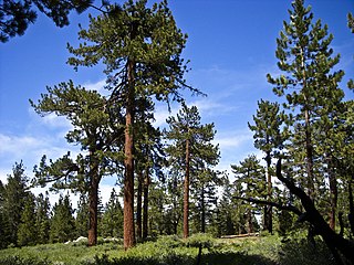
The longleaf pine is a pine species native to the Southeastern United States, found along the coastal plain from East Texas to southern Maryland, extending into northern and central Florida. It reaches a height of 30–35 m (98–115 ft) and a diameter of 0.7 m (28 in). In the past, before extensive logging, they reportedly grew to 47 m (154 ft) with a diameter of 1.2 m (47 in). The tree is a cultural symbol of the Southern United States, being the official state tree of Alabama. Contrary to popular belief, this particular species of pine is not officially the state tree of North Carolina.

In usage in the United States, a bayou is a body of water typically found in a flat, low-lying area, and may refer to an extremely slow-moving stream or river, a marshy lake or wetland or a creek whose current reverses daily due to tides, and which contains brackish water highly conducive to fish life and plankton. Bayous are commonly found in the Gulf Coast region of the southern United States, notably the Mississippi River Delta, with the states of Louisiana, Arkansas, Alabama, Mississippi, and Texas being famous for them. A bayou is frequently an anabranch or minor braid of a braided channel that is moving much slower than the mainstem, often becoming boggy and stagnant. Though fauna varies by region, many bayous are home to crawfish, certain species of shrimp, other shellfish, catfish, frogs, toads, salamanders, newts, American alligators, American crocodiles, herons, lizards, turtles, tortoises, spoonbills, snakes, leeches, and many other species.

Helianthus is a genus comprising about 70 species of annual and perennial flowering plants in the daisy family Asteraceae. Except for three South American species, the species of Helianthus are native to North America and Central America. The common names "sunflower" and "common sunflower" typically refer to the popular annual species Helianthus annuus, whose round flower heads in combination with the ligules look like the sun. This and other species, notably Jerusalem artichoke, are cultivated in temperate regions and some tropical regions as food crops for humans, cattle, and poultry, and as ornamental plants. The species H. annuus typically grows during the summer and into early fall, with the peak growth season being mid-summer.

Toulminville is a neighborhood of Mobile, Alabama, United States. It began as a small settlement on the property of Harry Theophilus Toulmin, who served as Sheriff of Mobile County in the 1830s. During the American Civil War, Toulminville was mapped along the Mobile and Ohio Railroad as a significant settlement, northwest of Mobile. In 1945, the remainder of Toulminville was annexed into the city of Mobile. The area of Toulminville has varied over the past decades from being an upper-middle class suburb to having a serious crime problem during most of the 1980s and 1990s, although the trend has been reversed in recent years.

The Coosa River is a tributary of the Alabama River in the U.S. states of Alabama and Georgia. The river is about 280 miles (450 km) long.

The southeastern pocket gopher is a species of pocket gopher that is native to the southeastern United States. It occurs in Alabama, Georgia, and Florida, where it is the only pocket gopher.
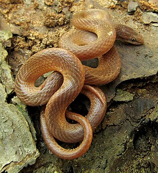
The pine woods snake, also commonly known as the yellow-lipped snake or the brown-headed snake, is a species of secretive colubrid found in scattered locations across the south-eastern United States. Rhadinaea flavilata is rear-fanged and mildly-venomous, but not dangerous to humans.

Prosartes lanuginosa is a North American plant species in the lily family with the common names yellow mandarin or yellow fairybells.

Geneva State Forest is an Alabama state forest in Geneva County, Alabama in the United States. The forest is 7,120 acres (2,880 ha) and sits at an elevation of 210 feet (64 m). It is Alabama's largest state forest. According to the Alabama Forestry Commission the primary objective of the state forest is to provide timber for the lumber industry and the secondary objectives are to provide habitats for wildlife and recreational opportunities for people. The forest is open for year-round recreation including hunting, fishing, hiking and camping.
Pine Level, also known as Pine Tucky, is an unincorporated community in Montgomery County, Alabama, United States. Pine Level is located along U.S. Route 231, 25 miles (40 km) southeast of Montgomery.

The William Bell No. 24 was a pilot boat used by the Sandy Hook Pilots in the 19th century. She was captured and burned by the Confederate raiding steamer CSS Tallahassee during the American Civil War. A second William Bell was constructed in 1864-1865 to replace the first one.
Escatawpa is an unincorporated community in Washington County, Alabama, United States.
Erie is a ghost town located in present-day Hale County, Alabama, United States. This was formerly the county seat of a larger Greene County, but the seat was moved to Eutaw in 1838 for the benefits of a more central location in a developing frontier area.
In ecology and forestry, yellow pine refers to a number of conifer species that tend to grow in similar plant communities and yield similar strong wood. In the Western United States, yellow pine refers to Jeffrey pine or ponderosa pine. In the Southeastern United States, yellow pine refers to longleaf pine, shortleaf pine, slash pine, or loblolly pine. In the United Kingdom, yellow pine refers to eastern white pine or Scots pine.

Hypericum tenuifolium, known as Atlantic St. John's-wort and sandhill St. John's-wort, is a species of flowering plant in the St. John's wort family, Hypericaceae. It is native to the Southeastern United States.