
Osmanabad District is an administrative district in the Marathwada region in the Indian state of Maharashtra. The district headquarter is located at Osmanabad. The District of Osmanabad derives its name from the last ruler of Hyderabad, the 7th Nizam, Mir Osman Ali Khan, of which the region was a part till 1947. This region was earlier part of The Hyderabad State until Independence.This primarily rural district occupies an area of 7,569 km2 (2,922 sq mi) of which 241.4 km2 (93.2 sq mi) is urban and has a population of 1,657,576 of which 16.96% were urban.
Ingoda is a village with a Gram panchayat in the Paranda Tehsil of Osmanabad district, Maharashtra state in India.
The 1993 Latur earthquake struck India at 3:56 am local time (UTC+05:30) on 30 September. The main area affected is the districts of Latur and Osmanabad, including the Ausa block of Latur and Omerga of Osmanabad in Maharashtra, Western India. Fifty-two villages were demolished in the intraplate earthquake. It measured 6.2 on the moment magnitude scale, and approximately 10,000 people died, whilst another 30,000 were injured. The earthquake's hypocenter was around 10 km deep – relatively shallow – allowing shock waves to cause more damage. It is considered the deadliest earthquake in the stable continental crust to have occurred in recorded history.

Osmanabad, officially known as Dharashiv, is a city and a municipal council in Osmanabad district in the Indian state of Maharashtra. Osmanabad derived its name from the last ruler of Hyderabad, Mir Osman Ali Khan. This city is the administrative headquarter of Osmanabad district. It is the seventh largest city in Marathwada While 39th largest city in Maharashtra by population.

Latur district is a district in Maharashtra state of India. Latur city is the district headquarters and is the 16th largest city in the state of Maharashtra. The district is primarily agricultural. Urban population comprises 25.47% of the total population.
Paranda is a town with a municipal council in the Osmanabad district of the Indian state of Maharashtra. It is the headquarters town for the Paranda Tehsil.
Umarga/ Omerga is a town with a municipal council in the Osmanabad district in the Indian state of Maharashtra. It is an administrative headquarter of the Umarga Tehsil.
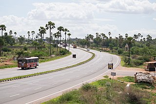
National Highway 65, , is a National Highway in India. It runs along the states of Maharashtra, Karnataka, Telangana and Andhra Pradesh. It starts at Pune and ends at Machilipatnam. Major cities on this route are Pune, Solapur, Hyderabad, Suryapet, Vijayawada and Machilipatnam. The section between Hyderabad and Vijayawada, is known as Vijayawada–Hyderabad Expressway and is a major expressway.

Latur is a city in the Indian state of Maharashtra, and is one of the largest cities of the Marathwada region. It is the administrative headquarters of Latur district and Latur Taluka. The city is a tourist hub surrounded by many historical monuments, including Udgir Fort and Kharosa Caves. The people in Latur are called Laturkar. The most spoken language in Latur is Marathi. The city's quality of education attracts students from all over Maharashtra. It is a drought prone area with acute water shortage in its city and rural areas. The economy is agriculture intensive and amounts in highest farmer suicide rates in India. Industrial development is minimal in the district. Latur is 43 kilometers from the epicenter of the devastating 1993 Latur earthquake.
Maharashtra State Highway 151, commonly referred to as SH 151, is a state highway that runs south through Solapur district in the state of Maharashtra. This state highway touches the cities of Barshi – Vairag – Solapur – Akkalkot and then proceeds south towards Maharashtra-Karnataka state border.
'Tuljapur Assembly constituency is one of the Maharashtra Vidhan Sabha constituencies, in Maharashtra state in western India.
Osmanabad Assembly constituency is one of the 288 Vidhan Sabha constituencies of Maharashtra state in western India.
Umarga (Omerga) Tehsil is a tehsil/ taluka/ subdistrict in Osmanabad district, Maharashtra on the Deccan Plateau of India. The town of Umarga is the administrative headquarters of the tehsil. There are 79 panchayat villages in Umarga Tehsil.
Alur is a panchayat village in the state of Maharashtra, India. It is administratively under the Umarga Tahsil of Osmanabad District in Maharashtra. There is only the single village of Alur in the Alur gram panchayat. The village is 31 km by road southeast of Naldurg and 52 km by road southwest of Umarga, but only 13 km by road northeast of Wagdari, in Solapur District.
Maharashtra Major State Highway 3, commonly referred to as MH MSH 3, is a major state highway that runs through Solapur, Osmanabad, Latur, Nanded, Yavatmal, Wardha and Nagpur districts in the state of Maharashtra and Major State Highway 11 (Maharashtra). This state highway touches numerous cities and villages VIZ. Solapur, Tuljapur, Ausa, Latur, Chakur, Ahmedpur, Nanded, Umarkhed, Mahagaon, Arni, Yavatmal, Wardha - Butibori - Via NH 7 Uptill Nagpur.

National Highway 161,, is a National Highway in India running through the states of Maharashtra and Telangana of India. The National Highway 161 joins the cities of Akola, Washim, Hingoli, Nanded, Degloor, Bichkunda, Pitlam, Nizampet, Shankarampet(A), Jogipet, Sanga Reddy.
Satara–Malshiras-Akluj-Barshi-Latur Highway is a national highway in the state of Maharashtra. This is a part of the Marathwada Integrated Road Development Project launched by the Government of Maharashtra by the Chief Minister Mr. Devendra Fadnavis.
National Highway 548B,commonly referred to as NH 548B is a national highway in India. It is a spur road of National Highway 48. NH-548B traverses the states of Maharashtra and Karnataka in India.
Naiknagar is a village in Maharashtra, India. It is located in Umarga Taluka in Osmanabad district. The village resides in the Marathwada region, and falls under the supervision of the Aurangabad division. Located 85 km towards east from the district headquarters Osmanabad, the village is also 13 km from Umarga, 474 km from the state capital Mumbai and 240 km from Hyderabad.Kalaburagi city is 80 km away from the village. Solapur is 65 km away from Naik nagar.

