Adams (village), New York

Last updated

Adams, New York
USA New York location map.svg
Red pog.svg
Adams
Usa edcp location map.svg
Red pog.svg
Adams
Coordinates: 43°48′33″N76°1′26″W / 43.80917°N 76.02389°W / 43.80917; -76.02389
Country United States
State New York
County Jefferson
Town Adams
Government
  MayorPhilip Chatterton
Area
[1]
  Total1.45 sq mi (3.74 km2)
  Land1.45 sq mi (3.74 km2)
  Water0.00 sq mi (0.00 km2)
Elevation
614 ft (187 m)
Population
 (2020)
  Total1,633
  Density1,130.10/sq mi (436.37/km2)
Time zone UTC-5 (Eastern (EST))
  Summer (DST) UTC-4 (EDT)
ZIP code
13605
Area code 315
FIPS code 36-00199
GNIS feature ID0942159
Website villageofadams.com

Adams is a village in the town of Adams in Jefferson County, New York, United States. The population was 1,775 at the 2010 census. [2] The village is named after President John Adams.

Contents

History

The village was first settled around 1800 and was called "Smith's Mills". It was incorporated in 1851. The historic core of the village was listed on the National Register of Historic Places in 2006 as the Adams Commercial Historic District. and the Smith-Ripley House was listed in 2008. [3]

Geography

Adams is located in southern Jefferson County at 43°48′32″N76°1′25″W / 43.80889°N 76.02361°W / 43.80889; -76.02361 (43.809088, -76.02385), [4] in the southern part of the town of Adams.

According to the United States Census Bureau, the village has a total area of 1.45 square miles (3.75 km2), all land. [2]

The village is adjacent to Interstate 81 and is located on U.S. Route 11 at New York State Route 178. I-81 and US-11 lead north 13 miles (21 km) to Watertown, the county seat, and south 55 miles (89 km) to Syracuse. NY-178 leads west 9 miles (14 km) to Henderson.

Sandy Creek is a stream that flows past the village on its southern border.

Demographics

Historical population
CensusPop.Note
1850 600
1860 1,268111.3%
1870 1,3526.6%
1880 1,250−7.5%
1890 1,3608.8%
1900 1,292−5.0%
1910 1,45812.8%
1920 1,5576.8%
1930 1,6133.6%
1940 1,594−1.2%
1950 1,76210.5%
1960 1,9148.6%
1970 1,9511.9%
1980 1,701−12.8%
1990 1,7533.1%
2000 1,624−7.4%
2010 1,7759.3%
2020 1,633−8.0%
U.S. Decennial Census [5]

At the 2000 census, [6] there were 1,624 people, 705 households and 425 families residing in the village. The population density was 1,054.0 inhabitants per square mile (407.0/km2). There were 781 housing units at an average density of 506.9 per square mile (195.7/km2). The racial makeup of the village was 97.91% White, 0.74% Black or African American, 0.25% Native American, 0.12% Asian, 0.18% from other races, and 0.80% from two or more races. Hispanic or Latino of any race were 1.11% of the population.

There were 705 households, of which 29.6% had children under the age of 18 living with them, 45.4% were married couples living together, 11.5% had a female householder with no husband present, and 39.6% were non-families. 33.3% of all households were made up of individuals, and 17.7% had someone living alone who was 65 years of age or older. The average household size was 2.30 and the average family size was 2.96.

Age distribution was 26.1% under the age of 18, 7.1% from 18 to 24, 28.9% from 25 to 44, 21.6% from 45 to 64, and 16.3% who were 65 years of age or older. The median age was 37 years. For every 100 females, there were 88.0 males. For every 100 females age 18 and over, there were 82.1 males.

The median household income was $30,677, and the median family income was $41,667. Males had a median income of $31,058 versus $25,724 for females. The per capita income for the village was $18,452. About 12.1% of families and 15.3% of the population were below the poverty line, including 22.6% of those under age 18 and 12.2% of those age 65 or over.

Notable people

Related Research Articles

<span class="mw-page-title-main">Canyon Day, Arizona</span> CDP in Gila County, Arizona

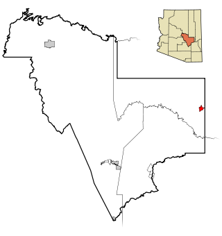
Canyon Day is a census-designated place (CDP) in Gila County, Arizona, United States, on the Fort Apache Indian Reservation. The population was 1,209 at the 2010 census.

<span class="mw-page-title-main">Long Creek, Illinois</span> Village in Illinois, United States

Long Creek is a village in Macon County, Illinois, United States. As of the 2020 census its 1,261. It is included in the Decatur, Illinois Metropolitan Statistical Area.

<span class="mw-page-title-main">Elkton, Kentucky</span> City in Kentucky, United States

Elkton is a home rule-class city in and the county seat of Todd County, Kentucky, United States. The population was 2,062 at the 2010 census.

<span class="mw-page-title-main">Sheridan, Michigan</span> Village in Michigan, United States

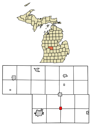
Sheridan is a village in Montcalm County in the U.S. state of Michigan. The population was 649 at the 2010 census. The village is located at the corners of four townships and incorporates land from each: Evergreen Township to the northeast, Bushnell Township to the southeast, Fairplain Township to the southwest, and Sidney Township to the northwest.

Adams Center is a hamlet and census-designated place (CDP) in the town of Adams in Jefferson County, New York, United States. The population was 1,492 during the 2020 decennial census.

<span class="mw-page-title-main">Martinsburg, New York</span> Town in New York, United States

Martinsburg is a town in Lewis County, New York, United States. The population was 1,433 at the 2010 census. The town is named after its founding father, General Walter Martin.

<span class="mw-page-title-main">Lacona, New York</span> Village in New York, United States

Lacona is a village in Oswego County, New York, United States. The population was 582 at the 2010 census.

<span class="mw-page-title-main">Forest Home, New York</span> CDP in New York, United States

Forest Home is a census-designated place (CDP) in Tompkins County, New York, United States. The population was 572 at the 2010 census.

<span class="mw-page-title-main">Middleburg Heights, Ohio</span> City in Ohio, United States

Middleburg Heights is a city in Cuyahoga County, Ohio, United States. It is a suburb about 11 miles (18 km) southwest of downtown Cleveland. The population was 16,004 at the 2020 census.

<span class="mw-page-title-main">Lockbourne, Ohio</span> Village in Ohio, United States

Lockbourne is a village in Franklin County and Pickaway County, Ohio, United States. The population was 236 at the 2020 census. Lockbourne is located near Rickenbacker International Airport, and had initially provided its original name of Lockbourne Air Force Base.

<span class="mw-page-title-main">Warwick Township, Lancaster County, Pennsylvania</span> Township in Pennsylvania, United States

Warwick Township is a township in north-central Lancaster County, Pennsylvania, United States. The population was 19,068 at the 2020 census. It completely surrounds the borough of Lititz and contains the unincorporated villages of Brunnerville, Disston, Kissel Hill, Lexington, Millway, and Rothsville.

<span class="mw-page-title-main">Friendship (village), Wisconsin</span> Village in Wisconsin, United States

Friendship is a village in Adams County in the U.S. state of Wisconsin. It is the county seat of Adams County. The population was 725 at the 2010 census.

<span class="mw-page-title-main">Taycheedah, Wisconsin</span> Town in Wisconsin, United States

Taycheedah is a town in Fond du Lac County, Wisconsin, United States. The population was 3,666 at the 2000 census. The census-designated places of St. Peter and Taycheedah and the unincorporated communities of Hopokoekau Beach, Linden Beach, Minawa Beach, Peebles, Silica, and Welling Beach are located in the town, as well as Malone, which is partially located in the town.

<span class="mw-page-title-main">Trumbull, Nebraska</span> Village in Clay and Adams counties in Nebraska, United States

Trumbull is a village in Clay and Adams counties in Nebraska, United States. The population was 198 at the 2020 census. It is part of the Hastings, Nebraska Micropolitan Statistical Area.

<span class="mw-page-title-main">Adams, New York</span> Town in New York, United States

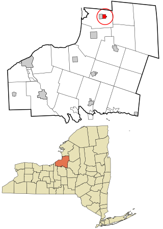
Adams is a town in Jefferson County, New York, United States. Named after President John Adams, the town had a population of 5,143 at the 2010 census. The town contains a village also named Adams. The village and town are south of Watertown.

<span class="mw-page-title-main">Camillus (village), New York</span> Village in New York, United States

Camillus is a village in Onondaga County, New York, United States. As of the 2020 census, the population was 1,222. The village takes its name from the town in which it is located. It is part of the Syracuse Metropolitan Statistical Area.

<span class="mw-page-title-main">Constantia (CDP), New York</span> CDP in New York, United States

Constantia is a census-designated place (CDP) in the town of Constantia in Oswego County, New York, United States. Located on Oneida Lake, the community lies along State Route 49 and Scriba Creek. The population was 1,182 at the 2010 census.

<span class="mw-page-title-main">Parish (village), New York</span> Village in New York, United States

Parish is a village located in the town of Parish, in Oswego County, New York, United States. This village is part of the Syracuse metropolitan area. Its population was 447 as of the census of 2020.

<span class="mw-page-title-main">Sandy Creek (village), New York</span> Village in New York, United States

Sandy Creek is a village in Oswego County, New York, United States. The population was 771 at the 2010 census.

<span class="mw-page-title-main">Genoa (town), Wisconsin</span> Human settlement in Vernon County, Wisconsin, United States of America

Genoa is a town in Vernon County, Wisconsin, United States. The population was 705 at the 2000 census. The Village of Genoa is located within the town. The unincorporated community of Romance is located in the town of Genoa.

References

  1. "ArcGIS REST Services Directory". United States Census Bureau. Retrieved September 20, 2022.
  2. 1 2 "Geographic Identifiers: 2010 Census Summary File 1 (G001): Adams village, New York". American Factfinder. U.S. Census Bureau. Archived from the original on February 13, 2020. Retrieved September 4, 2018.
  3. "National Register Information System". National Register of Historic Places . National Park Service. March 13, 2009.
  4. "US Gazetteer files: 2010, 2000, and 1990". United States Census Bureau. February 12, 2011. Retrieved April 23, 2011.
  5. "Census of Population and Housing". Census.gov. Retrieved June 4, 2015.
  6. "U.S. Census website". United States Census Bureau . Retrieved January 31, 2008.