La Fargeville, New York

Last updated

La Fargeville, New York
USA New York location map.svg
Red pog.svg
La Fargeville
Usa edcp location map.svg
Red pog.svg
La Fargeville
Coordinates: 44°11′39″N75°58′6″W / 44.19417°N 75.96833°W / 44.19417; -75.96833
Country United States
State New York
County Jefferson
Town Orleans
Area
[1]
  Total3.37 sq mi (8.73 km2)
  Land3.31 sq mi (8.58 km2)
  Water0.06 sq mi (0.14 km2)
Elevation
377 ft (115 m)
Population
 (2020)
  Total537
  Density162.04/sq mi (62.56/km2)
Time zone UTC-5 (Eastern (EST))
  Summer (DST) UTC-4 (EDT)
ZIP code
13656
Area code 315
FIPS code 36-40233
GNIS feature ID0954846

La Fargeville is a hamlet and census-designated place (CDP) in the town of Orleans in Jefferson County, New York, United States. The population was 733 at the 2020 census. [2] The hamlet is named after John Frederick La Farge, one of the early proprietors of the town. [3] La Fargeville was once a village, but dissolved its municipal corporation in 1922. [4]

Contents

La Fargeville is north of Watertown. The small hamlet has one school, LaFargeville Central School, which serves Pre-K through 12th grade. La Fargeville Central School is ranked the 911th largest public school, 17,312th nationally, and has a total student population of 552.

History

The hamlet was previously called "Log Mills" when it was first settled around 1816, due to the construction of a sawmill for logs. John Frederick La Farge, a French immigrant who had Americanized his name from Jean Frédéric de la Farge, arrived in 1826. Already wealthy from an import business he had set up in New Orleans, he began in the 1820s to buy real estate and build houses in Jefferson County, speculation that eventually led to La Fargeville being named after him. [3] His son John La Farge became a well-known artist.

By 1850, the population was about 300.

Geography

La Fargeville is in northern Jefferson County, in the central part of the town of Orleans. The Chaumont River, a southwest-flowing tributary of Lake Ontario, flows through the center of the community.

According to the United States Census Bureau, the CDP has a total area of 3.4 square miles (8.7 km2), of which 3.3 square miles (8.6 km2) are land and 0.04 square miles (0.1 km2), or 1.62%, are water. [2]

La Fargeville is at the junction of New York State Route 180 and New York State Route 411 (Plank Road). NY-180 leads north 7 miles (11 km) to Fishers Landing on the St. Lawrence River and south 14 miles (23 km) to Dexter at the mouth of the Black River into Lake Ontario. NY-411 leads east 4 miles (6 km) to Interstate 81 and 9 miles (14 km) to Theresa. County Road 181 (Plank Street) serves the hamlet from the west, leading 7 miles (11 km) to Clayton on the St. Lawrence. Watertown, the Jefferson county seat, is 17 miles (27 km) south of La Fargeville via Routes 180 and 12.

Demographics

Historical population
CensusPop.Note
2020 537
U.S. Decennial Census [5]

As of the census [6] of 2000, there were 588 people, 219 households, and 160 families residing in the CDP. The population density was 169.2 inhabitants per square mile (65.3/km2). There were 236 housing units at an average density of 67.9 per square mile (26.2/km2). The racial makeup of the CDP was 95.41% White, 2.21% African American, 1.36% Native American, 0.34% Asian, and 0.68% from two or more races. Hispanic or Latino of any race were 0.17% of the population.

There were 219 households, out of which 32.9% had children under the age of 18 living with them, 54.3% were married couples living together, 13.7% had a female householder with no husband present, and 26.9% were non-families. 25.6% of all households were made up of individuals, and 10.5% had someone living alone who was 65 years of age or older. The average household size was 2.67 and the average family size was 3.11.

In the CDP, the population was spread out, with 28.2% under the age of 18, 8.3% from 18 to 24, 27.9% from 25 to 44, 22.8% from 45 to 64, and 12.8% who were 65 years of age or older. The median age was 36 years. For every 100 females, there were 82.6 males. For every 100 females age 18 and over, there were 81.9 males.

The median income for a household in the CDP was $29,286, and the median income for a family was $41,705. Males had a median income of $21,750 versus $24,306 for females. The per capita income for the CDP was $13,816. About 22.5% of families and 28.1% of the population were below the poverty line, including 48.9% of those under age 18 and 8.9% of those age 65 or over.

Related Research Articles

<span class="mw-page-title-main">Oakville, Connecticut</span> Census-designated place in Connecticut, United States

Oakville is a census-designated place (CDP) and neighborhood section of Watertown, in Litchfield County, Connecticut, United States. The population was 9,047 as of the 2010 census. It is the most populous community in Watertown, with more than twice as many people as the center village of Watertown. The ZIP code for Oakville is 06779.

Houghton is a hamlet located in the Town of Caneadea in Allegany County, western New York, United States. The population was 1,693 at the 2010 census.

Stottville is a hamlet and census-designated place (CDP) in Columbia County, New York, United States. The population was 1,375 at the 2010 census.

<span class="mw-page-title-main">Hillside Lake, New York</span> Census-designated place in New York, United States

Hillside Lake is a hamlet and census-designated place (CDP) in Dutchess County, New York, United States. The population was 1,084 at the 2010 census. It is part of the Poughkeepsie–Newburgh–Middletown, NY Metropolitan Statistical Area as well as the larger New York–Newark–Bridgeport, NY-NJ-CT-PA Combined Statistical Area.

Jefferson Heights is a hamlet and census-designated place (CDP) in Greene County, New York, United States. The population was 1,122 at the 2020 census.

Adams Center is a hamlet and census-designated place (CDP) in the town of Adams in Jefferson County, New York, United States. The population was 1,492 during the 2020 decennial census.

Calcium is a census-designated place (CDP) in Jefferson County, New York, United States. The population was 3,573 as of the 2020 census. The CDP is in the town of Le Ray and includes the hamlets of Calcium and Sanfords Four Corners.

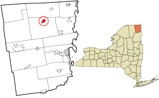
Deferiet is a village in Jefferson County, New York, United States. The population was 294 at the 2010 census. The village is named after settler Jenika de Ferriet.

Depauville is a hamlet and census-designated place (CDP) in the southern region of the town of Clayton, within Jefferson County, New York, United States. The population was at 577 at the 2010 census.

Dexter is a village in Jefferson County, New York, United States. The population was 1,052 at the 2010 census. The name is derived from Simon Newton Dexter, one of the village's stockholders.

Great Bend is a hamlet and census-designated place (CDP) in Jefferson County, New York, United States. The population was 843 at the 2010 census.

Herrings is a hamlet and former village in Jefferson County, New York, United States. The population was 90 at the 2010 census, down from 129 in 2000. The hamlet is named after two brothers who owned a paper mill in the area.

<span class="mw-page-title-main">Natural Bridge, New York</span> Census-designated place in New York, United States

Natural Bridge is a hamlet and census-designated place (CDP) in Jefferson County, New York, United States. As of the 2010 census it had a population of 365.

Orleans is a town in Jefferson County, New York, United States. The population was 2,789 at the 2010 census, up from 2,463 in 2000. The town is located in the northern part of the county and is north of Watertown. Orleans is named after the commune of Orléans in France.

Pamelia is a town in Jefferson County, New York, United States. The population was 3,160 at the 2010 census, up from 2,897 in 2000. The town was named for Pamelia Williams, wife of landowner and developer General Jacob J. Brown.

Redwood is a hamlet and census-designated place (CDP) in Jefferson County, New York, United States. As of the 2010 census, the population was 605.

<span class="mw-page-title-main">Altona (CDP), New York</span> Census-designated place in New York, United States

Altona is a hamlet and census-designated place (CDP) in the town of Altona, Clinton County, New York, United States. The population was 730 at the 2010 census, out of a total town population of 2,887.

Greenville is a hamlet and census-designated place (CDP) in the town of Greenville, in Greene County, New York, United States. The population of the CDP was 688 at the 2010 census, out of a total 3,739 people in the town as a whole.

<span class="mw-page-title-main">Huntington (CDP), New York</span> Place in New York, United States

Huntington is a hamlet and census-designated place (CDP) located within the Town of Huntington in Suffolk County, on the North Shore of Long Island, in New York, United States. The population was 18,406 at the 2010 census. The hamlet serves as the Town Seat of the Town of Huntington.

<span class="mw-page-title-main">Jefferson Valley, New York</span> Census-designated place in New York, United States

Jefferson Valley-Yorktown, commonly known as Jefferson Valley, is a census-designated place (CDP) located in the town of Yorktown in Westchester County, New York, United States. The population was 14,142 at the 2010 census. It is a hot spot for local shoppers, due to its Jefferson Valley Mall.

References

  1. "ArcGIS REST Services Directory". United States Census Bureau. Retrieved September 20, 2022.
  2. 1 2 "Geographic Identifiers: 2010 Census Summary File 1 (G001): La Fargeville CDP, New York". American Factfinder. U.S. Census Bureau. Archived from the original on February 13, 2020. Retrieved October 3, 2018.
  3. 1 2 Yarnall, James L. John La Farge: A Biographical and Critical Study. Ashgate 2012.
  4. "Local Government Handbook - Table 13" (PDF) (5th ed.). New York State Department of State. 2008. p. 77. Archived from the original (PDF) on February 15, 2010. Retrieved June 6, 2009.
  5. "Census of Population and Housing". Census.gov. Retrieved June 4, 2016.
  6. "Profile of General Demographic Characteristics: Census 2000 Summary File 1 (SF 1) 100-Percent Data (DP-1): La Fargeville CDP, New York". American Factfinder. U.S. Census Bureau. Archived from the original on February 13, 2020. Retrieved October 3, 2018.