Watertown (town), New York

Last updated

Watertown, New York
USA New York location map.svg
Red pog.svg
Watertown (town)
Usa edcp location map.svg
Red pog.svg
Watertown (town)
Coordinates: 43°56′10″N75°55′29″W / 43.93611°N 75.92472°W / 43.93611; -75.92472
Country United States
State New York
County Jefferson
Government
  Type Town Council
   Town Supervisor Joel R. Bartlett (D)
   Town Council
Members' List
Area
  Total35.8 sq mi (92.7 km2)
  Land35.7 sq mi (92.4 km2)
  Water0.1 sq mi (0.3 km2)
Elevation
538 ft (164 m)
Population
 (2020) [1]
  Total5,913
  Density165.7/sq mi (64.0/km2)
Time zone UTC-5 (Eastern (EST))
  Summer (DST) UTC-4 (EDT)
ZIP codes
13601-13603
Area code 315
FIPS code 36-78619 [2]
GNIS feature ID0979605 [3]
Website townofwatertownny.org

Watertown is a town in Jefferson County, New York, United States. The population was 5,913 at the 2020 census. [1] The town is located in the central part of the county and borders the city of Watertown to the south, east, and west. As the city has a population of 24,685, or four times the town's population, references to "Watertown, New York", usually apply to the city rather than the town.

Contents

History

Numerous sites of aboriginal habitation were found by early surveyors of this region. The region was later part of Macomb's Purchase.

Watertown was established as a town on March 14, 1800, from Mexico before the formation of Jefferson County, while still in Oneida County. The towns of Rutland (1802) and Hounsfield (1806) were soon formed from parts of Watertown.

The town was first settled in 1800 around the time of the first permanent US military presence in the region, which was established at nearby Sackets Harbor to guard the international border and to fight smuggling in the St. Lawrence region.

In 1816, the community of Watertown set itself off from the town by incorporating as a village. It became a city in 1869.

The John Losee House was added to the National Register of Historic Places in 2014. [4]

Geography

According to the United States Census Bureau, the town has a total area of 35.8 square miles (92.7 km2), of which 35.7 square miles (92.4 km2) are land and 0.1 square miles (0.3 km2), or 0.28%, are water. [5] The town is bordered to the north by the city of Watertown and by the Black River.

The town of Watertown is in central Jefferson County, and is bordered to the north by the city of Watertown and the towns of Brownville, Pamelia and Le Ray, to the east by the town of Rutland, to the south by the towns of Adams and Rodman, and to the west by the town of Hounsfield.

Interstate 81 passes through the western part of the town. U.S. Route 11 is a north–south highway running parallel to I-81 through the town. New York State Route 3, New York State Route 12, New York State Route 12F, New York State Route 126, and New York State Route 232 are east–west highways through Watertown. Many of these highways converge in the city of Watertown.

The area is served by Watertown International Airport to the west in the town of Hounsfield.

Three full-power television stations, WPBS, WWNY (CBS) and WWTI (ABC), currently serve the Watertown area.

Demographics

Historical population
CensusPop.Note
1820 2,766
1830 4,76872.4%
1840 5,0275.4%
1850 7,20143.2%
1860 7,5675.1%
1870 1,373−81.9%
1880 1,264−7.9%
1890 1,215−3.9%
1900 1,159−4.6%
1910 1,097−5.3%
1920 1,1161.7%
1930 1,27013.8%
1940 1,39910.2%
1950 1,75225.2%
1960 2,49242.2%
1970 3,02621.4%
1980 3,0982.4%
1990 4,34140.1%
2000 4,4823.2%
2010 4,470−0.3%
2020 5,91332.3%
U.S. Decennial Census [6]

As of the census of 2000, there were 4,482 people, 1,407 households, and 1,018 families residing in the town. The population density was 124.6 inhabitants per square mile (48.1/km2). There were 1,502 housing units at an average density of 41.7 per square mile (16.1/km2). The racial makeup of the town was 83.94% White, 11.24% Black, 0.33% Native American, 0.60% Asian, 0.02% Pacific Islander, 3.39% from other races, and 0.47% from two or more races. Hispanic or Latino of any race were 6.85% of the population.

There were 1,407 households, out of which 34.7% had children under the age of 18 living with them, 61.2% were married couples living together, 7.3% had a female householder with no husband present, and 27.6% were non-families. 22.4% of all households were made up of individuals, and 9.5% had someone living alone who was 65 years of age or older. The average household size was 2.57 and the average family size was 3.02.

In the town, the population was spread out, with 21.3% under the age of 18, 6.8% from 18 to 24, 37.6% from 25 to 44, 24.4% from 45 to 64, and 9.9% who were 65 years of age or older. The median age was 37 years. For every 100 females, there were 143.6 males. For every 100 females age 18 and over, there were 158.0 males.

The median income for a household in the town was $41,961, and the median income for a family was $46,563. Males had a median income of $35,475 versus $21,638 for females. The per capita income for the town was $21,786. About 3.8% of families and 4.7% of the population were below the poverty line, including 5.6% of those under age 18 and 1.7% of those age 65 or over. [2]

Communities and locations in the Town of Watertown

Related Research Articles

<span class="mw-page-title-main">Jefferson County, New York</span> County in New York, United States

Jefferson County is a county on the northern border of the U.S. state of New York. As of the 2020 census, the population was 116,721. Its county seat is Watertown. The county is named after Thomas Jefferson, third President of the United States of America. It is adjacent to Lake Ontario, southeast from the Canada–US border of Ontario. The county is part of the North Country region of the state.

Adams Center is a hamlet and census-designated place (CDP) in the town of Adams in Jefferson County, New York, United States. The population was 1,492 during the 2020 decennial census.

Champion is a town in Jefferson County, New York, United States. The population was 4,494 at the 2010 census. The town is named after General Henry Champion, early owner.

Deferiet is a village in Jefferson County, New York, United States. The population was 294 at the 2010 census. The village is named after settler Jenika de Ferriet.

<span class="mw-page-title-main">Dexter, New York</span> Village in New York, United States

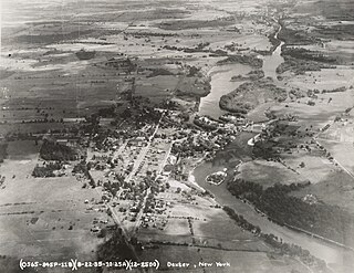
Dexter is a village in Jefferson County, New York, United States. The population was 1,052 at the 2010 census. The name is derived from Simon Newton Dexter, one of the village's stockholders.

Great Bend is a hamlet and census-designated place (CDP) in Jefferson County, New York, United States. The population was 843 at the 2010 census.

Herrings is a hamlet and former village in Jefferson County, New York, United States. The population was 90 at the 2010 census, down from 129 in 2000. The hamlet is named after two brothers who owned a paper mill in the area.

Hounsfield is a town in Jefferson County, New York, United States. The population was 3,466 at the 2010 census. The name of the town is from Ezra Hounsfield, a land agent and land owner.

La Fargeville is a hamlet and census-designated place (CDP) in the town of Orleans in Jefferson County, New York, United States. The population was 733 at the 2020 census. The hamlet is named after John Frederick La Farge, one of the early proprietors of the town. La Fargeville was once a village, but dissolved its municipal corporation in 1922.

Le Ray is a town in Jefferson County, New York, United States. The population was 25,574 at the 2020 census, up from 21,782 in 2010. The town is named for Jacques-Donatien Le Ray, known as a French "father of the American Revolution".

Orleans is a town in Jefferson County, New York, United States. The population was 2,789 at the 2010 census, up from 2,463 in 2000. The town is located in the northern part of the county and is north of Watertown. Orleans is named after the commune of Orléans in France.

Pamelia is a town in Jefferson County, New York, United States. The population was 3,160 at the 2010 census, up from 2,897 in 2000. The town was named for Pamelia Williams, wife of landowner and developer General Jacob J. Brown.

Rodman is a town in Jefferson County, New York, United States. The population was 1,176 at the 2010 census. The name is derived from a public official, Daniel Rodman.

Rutland is a town in Jefferson County, New York, United States. The population was 3,038 at the 2020 census.

Wilna is a town in Jefferson County, New York, United States. The population was 5,732 at the 2020 census. The town is on the eastern side of the county and is east of Watertown.

Pinckney is a town in Lewis County, New York, United States. The population was 329 at the 2010 census. The town is named after Thomas Pinckney of South Carolina.

Antwerp is a town in Jefferson County, New York, United States. The population was 1,683 at the 2020 census. The town is named after Antwerp, Belgium, the home of the early investors in the town, who had organized under the name of the Antwerp Company.

<span class="mw-page-title-main">Brownville (village), New York</span> Village in New York, United States

Brownville is a village in Jefferson County, New York, United States. The population was 1,119 at the 2010 census, up from 1,022 in 2000. The village is named after Jacob Brown, an early settler and developer.

Brownville is a town in Jefferson County, New York, United States. The population was 6,263 at the 2010 census, up from 5,839 in 2000. The town is named after Jacob Brown, an early settler and leader.

Cape Vincent is a town in Jefferson County, New York, United States. The population was 2,765 at the 2020 census.

References

  1. 1 2 "Profile of General Population and Housing Characteristics: 2020 Demographic Profile Data (DP-1): Watertown town, Jefferson County, New York". United States Census Bureau . Retrieved March 9, 2024.
  2. 1 2 "U.S. Census website". United States Census Bureau. Archived from the original on December 27, 1996. Retrieved January 31, 2008.
  3. "US Board on Geographic Names". United States Geological Survey. October 25, 2007. Archived from the original on February 12, 2012. Retrieved January 31, 2008.
  4. "National Register of Historic Places Listings". Weekly List of Actions Taken on Properties: 2/10/14 through 2/14/14. National Park Service. February 21, 2014.
  5. "2020 U.S. Gazetteer Files". United States Census Bureau. Retrieved March 9, 2024.
  6. "Census of Population and Housing". Census.gov. Archived from the original on April 26, 2015. Retrieved June 4, 2015.