
Oakville is a census-designated place (CDP) and neighborhood section of Watertown, in Litchfield County, Connecticut, United States. The population was 9,047 as of the 2010 census. It is the most populous community in Watertown, with more than twice as many people as the center village of Watertown. The ZIP code for Oakville is 06779.
Hillsdale is a village in Rock Island County, Illinois, United States. The population was 523 at the 2010 census.

Wallagrass is a town in Aroostook County, Maine, United States. The population was 519 at the 2020 census.
Lee is a town in Penobscot County, Maine, United States. It was incorporated in 1832. The town was originally called Mattekeunk, but changed it to Lee to give it n English name. Stephen Lee suggested the town be named Lee after Revolutionary general Henry "High Horse" Lee. To further convince the townsfolk, he brought a barrel of rum to the meeting. The population was 916 at the 2020 census. Lee has been home to Lee Academy since 1845.

Watertown is a small city in Carver County, Minnesota, United States, along the South Fork of the Crow River, on the outskirts of the Twin Cities metro area. The population was 4,659 at the 2020 census.
Deferiet is a village in Jefferson County, New York, United States. The population was 294 at the 2010 census. The village is named after settler Jenika de Ferriet.
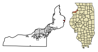
Dexter is a village in Jefferson County, New York, United States. The population was 1,052 at the 2010 census. The name is derived from Simon Newton Dexter, one of the village's stockholders.
Evans Mills is a village in Jefferson County, New York, United States. The population was 621 at the 2010 census. The village is within the town of Le Ray and is northeast of Watertown.
Glen Park is a village in Jefferson County, New York, United States. The population was 502 at the 2010 census. The village is on the border of the towns of Brownville and Pamelia and is immediately northwest of Watertown.
Herrings is a hamlet and former village in Jefferson County, New York, United States. The population was 90 at the 2010 census, down from 129 in 2000. The hamlet is named after two brothers who owned a paper mill in the area.

Barker is a village in Niagara County, New York. The population was 533 at the time of the 2010 census. The mail ZIP code is 14012. It is part of the Buffalo–Niagara Falls Metropolitan Statistical Area.

Quaker City is a village in Guernsey County, Ohio, United States. The population was 379 at the 2020 census.

Clearview is a village in Ohio County, West Virginia, United States. It is part of the Wheeling, West Virginia Metropolitan Statistical Area. The population was 565 at the 2010 census.
Watertown is a town in Jefferson County, Wisconsin, United States. The population was 1,975 at the 2010 census. The unincorporated community of Ebenezer is located in the town.
Antwerp is a village in Jefferson County, New York, United States. The population was 686 at the 2010 census. The village is in center of the town of Antwerp and is northeast of Watertown.

Brownville is a village in Jefferson County, New York, United States. The population was 1,119 at the 2010 census, up from 1,022 in 2000. The village is named after Jacob Brown, an early settler and developer.
Ellisburg is a village in Jefferson County, New York, United States. The population was 244 at the 2010 census. The village is named after two brothers who were the original landowners. It is located near the middle of the town of Ellisburg and is southwest of Watertown.
Theresa is a village in the town of Theresa in Jefferson County, New York, United States. The population was 863 at the 2010 census. The village is northeast of Watertown.
Philadelphia is a town in Jefferson County, New York, United States. The population was 1,947 at the 2010 census, down from 2,140 in 2000.

Watertown is a census-designated place (CDP) in Litchfield County, Connecticut, United States. It comprises the central village of the town of Watertown. As of the 2010 census, the population of the CDP was 3,574, out of 22,514 in the entire town. As of the 2020 Census, the population was 22,105.


