Ellisburg (village), New York

Last updated
Ellisburg, New York
USA New York location map.svg
Red pog.svg
Ellisburg
Usa edcp location map.svg
Red pog.svg
Ellisburg
Coordinates: 43°43′54″N76°8′1″W / 43.73167°N 76.13361°W / 43.73167; -76.13361
Country United States
State New York
County Jefferson
Town Ellisburg
Area
[1]
  Total1.00 sq mi (2.59 km2)
  Land1.00 sq mi (2.59 km2)
  Water0.00 sq mi (0.00 km2)
Elevation
328 ft (100 m)
Population
 (2020)
  Total186
  Density185.81/sq mi (71.72/km2)
Time zone UTC-5 (Eastern (EST))
  Summer (DST) UTC-4 (EDT)
ZIP code
13636
Area code 315
FIPS code 36-24075
GNIS feature ID0975770

Ellisburg is a village in Jefferson County, New York, United States. The population was 244 at the 2010 census. [2] The village is named after two brothers who were the original landowners. It is located near the middle of the town of Ellisburg and is southwest of Watertown.

Contents

History

The village was first settled circa 1797 by Lyman Ellis and was also called "Ellisburgh". The village set itself off from the town by incorporation in 1895.

Geography

Ellisburg is located in southern Jefferson County at 43°43′54″N76°8′1″W / 43.73167°N 76.13361°W / 43.73167; -76.13361 (43.731775, -76.133695). [3] According to the United States Census Bureau, it has a total area of 1.0 square mile (2.6 km2), all land. [2]

South Sandy Creek flows through the center of the village, leading southwestward to Lake Ontario.

Ellisburg is at the junction of New York State Route 193, New York State Route 289, and County Road 87. NY-193 leads 4 miles (6 km) east to Pierrepont Manor and northwest the same distance to NY-3 at Southwick Beach State Park near Lake Ontario. NY-289 leads north 3.5 miles (5.6 km) to Belleville. Interstate 81 is 3.5 miles (5.6 km) east of Ellisburg via NY-193 and leads an additional 20 miles (32 km) north to Watertown, the county seat.

Demographics

Historical population
CensusPop.Note
1880 222
1890 33651.4%
1900 292−13.1%
1910 702140.4%
1920 275−60.8%
1930 253−8.0%
1940 2530.0%
1950 28512.6%
1960 32815.1%
1970 3372.7%
1980 307−8.9%
1990 246−19.9%
2000 2699.3%
2010 244−9.3%
2020 186−23.8%
U.S. Decennial Census [4]

As of the census [5] of 2000, there were 269 people, 91 households, and 69 families residing in the village. The population density was 266.1 inhabitants per square mile (102.7/km2). There were 100 housing units at an average density of 98.9 per square mile (38.2/km2). The racial makeup of the village was 99.26% White, and 0.74% from two or more races. Hispanic or Latino of any race were 0.37% of the population.

There were 91 households, out of which 45.1% had children under the age of 18 living with them, 57.1% were married couples living together, 15.4% had a female householder with no husband present, and 23.1% were non-families. 17.6% of all households were made up of individuals, and 11.0% had someone living alone who was 65 years of age or older. The average household size was 2.96 and the average family size was 3.34.

In the village, the population was spread out, with 30.9% under the age of 18, 11.9% from 18 to 24, 28.3% from 25 to 44, 19.0% from 45 to 64, and 10.0% who were 65 years of age or older. The median age was 35 years. For every 100 females, there were 94.9 males. For every 100 females age 18 and over, there were 97.9 males.

The median income for a household in the village was $39,750, and the median income for a family was $45,313. Males had a median income of $31,875 versus $20,000 for females. The per capita income for the village was $14,569. About 18.8% of families and 21.6% of the population were below the poverty line, including 35.3% of those under the age of eighteen and none of those 65 or over.

Notable person

Related Research Articles

<span class="mw-page-title-main">Ruma, Illinois</span> Village in Illinois, United States

Ruma is a village in Randolph County, Illinois, United States. The population was 317 at the 2010 census.

Munsons Corners is a hamlet and census-designated place (CDP) in Cortland County, New York, United States. The population was 2,728 at the 2010 census.

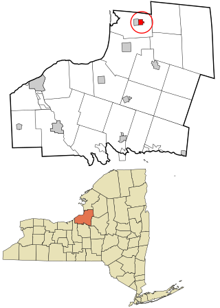
Adams Center is a hamlet and census-designated place (CDP) in the town of Adams in Jefferson County, New York, United States. The population was 1,492 during the 2020 decennial census.

Alexandria Bay is a village in Jefferson County, New York, United States, within the town of Alexandria. It is located in the Thousand Islands region of northern New York. The population of the village was 1,078 at the 2010 United States Census. It lies near the Thousand Islands Border Crossing of Canada and the United States.

Carthage is a village in the town of Wilna in Jefferson County, New York, United States. The population was 3,747 at the 2010 census. The village is named after the historic city of Carthage.

Deferiet is a village in Jefferson County, New York, United States. The population was 294 at the 2010 census. The village is named after settler Jenika de Ferriet.

Dexter is a village in Jefferson County, New York, United States. The population was 1,052 at the 2010 census. The name is derived from Simon Newton Dexter, one of the village's stockholders.

Glen Park is a village in Jefferson County, New York, United States. The population was 502 at the 2010 census. The village is on the border of the towns of Brownville and Pamelia and is immediately northwest of Watertown.

Mannsville is a village in the town of Ellisburg in Jefferson County, New York, United States. The population was 354 at the 2010 census, down from 400 in 2000. The name is from Barzillian Mann, early developer.

West Carthage is a village in Jefferson County, New York, United States. The population was 2,012 at the 2010 census.

Altmar is a hamlet in Oswego County, New York, United States. The population was 407 at the 2010 census.

<span class="mw-page-title-main">Lacona, New York</span> Village in New York, United States

Lacona is a village in Oswego County, New York, United States. The population was 582 at the 2010 census.

<span class="mw-page-title-main">Little Meadows, Pennsylvania</span> Borough in Pennsylvania, United States

Little Meadows is a borough in Susquehanna County, Pennsylvania, United States. The population was 247 at the 2020 census.

<span class="mw-page-title-main">Williston, Tennessee</span> City in Tennessee, United States

Williston is a city in Fayette County, Tennessee, United States. The population was 395 at the 2010 census.

Adams is a village in the town of Adams in Jefferson County, New York, United States. The population was 1,775 at the 2010 census. The village is named after President John Adams.

<span class="mw-page-title-main">Brownville (village), New York</span> Village in New York, United States

Brownville is a village in Jefferson County, New York, United States. The population was 1,119 at the 2010 census, up from 1,022 in 2000. The village is named after Jacob Brown, an early settler and developer.

Ellisburg is an incorporated town in Jefferson County, New York. The population was 3,474 at the time of the 2010 census. The town is in the southwestern corner of the county and is south of Watertown. Ellisburg is named after early European-American landowners. Among the villages in the town is Ellisburg.

Philadelphia is a village in Jefferson County, New York, United States. The population was 1,252 at the 2010 census, down from 1,519 in 2000.

Theresa is a village in the town of Theresa in Jefferson County, New York, United States. The population was 863 at the 2010 census. The village is northeast of Watertown.

<span class="mw-page-title-main">Watertown (CDP), Connecticut</span> Census-designated place in Connecticut, United States

Watertown is a census-designated place (CDP) in Litchfield County, Connecticut, United States. It comprises the central village of the town of Watertown. As of the 2010 census, the population of the CDP was 3,574, out of 22,514 in the entire town.

References

  1. "ArcGIS REST Services Directory". United States Census Bureau. Retrieved September 20, 2022.
  2. 1 2 "Geographic Identifiers: 2010 Census Summary File 1 (G001): Ellisburg village, New York". American Factfinder. U.S. Census Bureau. Archived from the original on February 13, 2020. Retrieved September 11, 2018.
  3. "US Gazetteer files: 2010, 2000, and 1990". United States Census Bureau. 2011-02-12. Retrieved 2011-04-23.
  4. "Census of Population and Housing". Census.gov. Retrieved June 4, 2015.
  5. "U.S. Census website". United States Census Bureau . Retrieved 2008-01-31.