Glen Park, New York

Last updated

Glen Park, New York
USA New York location map.svg
Red pog.svg
Glen Park
Usa edcp location map.svg
Red pog.svg
Glen Park
Coordinates: 43°59′56″N75°57′8″W / 43.99889°N 75.95222°W / 43.99889; -75.95222
Country United States
State New York
County Jefferson
Towns Brownville, Pamelia
Area
[1]
  Total0.75 sq mi (1.95 km2)
  Land0.71 sq mi (1.85 km2)
  Water0.04 sq mi (0.10 km2)
Elevation
341 ft (104 m)
Population
 (2020)
  Total452
  Density633.05/sq mi (244.38/km2)
Time zone UTC-5 (Eastern (EST))
  Summer (DST) UTC-4 (EDT)
ZIP code
13601
Area code 315
FIPS code 36-29322
GNIS feature ID0970168

Glen Park is a village in Jefferson County, New York, United States. The population was 502 at the 2010 census. [2] The village is on the border of the towns of Brownville and Pamelia and is immediately northwest of Watertown.

Contents

History

The village was built up around the Remington Paper Company and incorporated in 1893.

The village was also the site of an amusement and picnic grounds operated by a local streetcar company. Extensive caves and endangered bat hibernaculum in the vicinity.

Geography

Glen Park is located in central Jefferson County at 43°59′56″N75°57′8″W / 43.99889°N 75.95222°W / 43.99889; -75.95222 (43.998895, -75.952235). [3] The majority of the village is in the southeastern corner of the town of Brownville, with a small portion extending east into the town of Pamelia. The village is bordered to the west by the village of Brownville and to the south by the Black River, which forms the border with the town of Watertown.

According to the United States Census Bureau, Glen Park has a total area of 0.73 square miles (1.9 km2), of which 0.02 square miles (0.06 km2), or 3.30%, are water. [2]

County Route 190, sometimes shown on maps as New York State Route 12E, is the main road through Glen Park. It leads southeast (upstream along the Black River) 3.8 miles (6.1 km) to the center of Watertown and west 0.7 miles (1.1 km) to NY-12E in Brownville village.

Demographics

Historical population
CensusPop.Note
1900 494
1910 5225.7%
1920 66126.6%
1930 559−15.4%
1940 523−6.4%
1950 516−1.3%
1960 5618.7%
1970 5874.6%
1980 504−14.1%
1990 5274.6%
2000 487−7.6%
2010 5023.1%
2020 452−10.0%
U.S. Decennial Census [4]

As of the census [5] of 2000, there were 487 people, 175 households, and 131 families residing in the village. The population density was 693.5 inhabitants per square mile (267.8/km2). There were 190 housing units at an average density of 270.5 per square mile (104.4/km2). The racial makeup of the village was 96.92% White, 0.21% African American, 0.82% Native American, 0.41% Asian, 1.03% from other races, and 0.62% from two or more races. Hispanic or Latino of any race were 1.23% of the population.

There were 175 households, out of which 45.1% had children under the age of 18 living with them, 53.7% were married couples living together, 13.1% had a female householder with no husband present, and 25.1% were non-families. 21.7% of all households were made up of individuals, and 8.6% had someone living alone who was 65 years of age or older. The average household size was 2.78 and the average family size was 3.18.

In the village, the population was spread out, with 31.2% under the age of 18, 7.2% from 18 to 24, 31.6% from 25 to 44, 17.0% from 45 to 64, and 12.9% who were 65 years of age or older. The median age was 32 years. For every 100 females, there were 87.3 males. For every 100 females age 18 and over, there were 93.6 males.

The median income for a household in the village was $32,250, and the median income for a family was $42,500. Males had a median income of $33,750 versus $20,500 for females. The per capita income for the village was $13,159. About 8.9% of families and 14.3% of the population were below the poverty line, including 14.3% of those under age 18 and 16.0% of those age 65 or over.

Related Research Articles

<span class="mw-page-title-main">Jefferson County, New York</span> County in New York, United States

Jefferson County is a county on the northern border of the U.S. state of New York. As of the 2020 census, the population was 116,721. Its county seat is Watertown. The county is named after Thomas Jefferson, third President of the United States of America. It is adjacent to Lake Ontario, southeast from the Canada–US border of Ontario. The county is part of the North Country region of the state.

<span class="mw-page-title-main">Nemaha County, Nebraska</span> County in Nebraska, United States

Nemaha County is a county in the U.S. state of Nebraska. As of the 2020 United States Census, the population was 7,074. Its county seat is Auburn.

<span class="mw-page-title-main">Brownville, Maine</span> Town in the state of Maine, United States

Brownville is a town in Piscataquis County, Maine, United States. The population was 1,139 at the 2020 census. The town includes the villages of Brownville, Knight's Landing and Brownville Junction, near which passes the 100-Mile Wilderness of the Appalachian Trail.

Carthage is a village in the town of Wilna in Jefferson County, New York, United States. The population was 3,236 at the 2020 census. The village is named after the historic city of Carthage.

Champion is a town in Jefferson County, New York, United States. The population was 4,494 at the 2010 census. The town is named after General Henry Champion, early owner.

Chaumont is a village in Jefferson County, New York, United States. Its population was 624 at the 2010 census. The village is named for Jacques-Donatien Le Ray de Chaumont, son of Benjamin Franklin's landlord and friend at Passy in France. The village of Chaumont is in the town of Lyme and is northwest of Watertown.

<span class="mw-page-title-main">Dexter, New York</span> Village in New York, United States

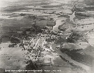
Dexter is a village in Jefferson County, New York, United States. The population was 1,052 at the 2010 census. The name is derived from Simon Newton Dexter, one of the village's stockholders.

Lyme is a town in Jefferson County, New York, United States. The population was 2,185 at the 2010 census. The settlements of Chaumont and Three Mile Bay are located within the town. Lyme is in the western part of Jefferson County and is northwest of Watertown.

Pamelia is a town in Jefferson County, New York, United States. The population was 3,160 at the 2010 census, up from 2,897 in 2000. The town was named for Pamelia Williams, wife of landowner and developer General Jacob J. Brown.

West Carthage is a village in Jefferson County, New York, United States. The population was 1,780 at the 2020 census.

Dix is a town in Schuyler County, New York, United States. The population was 3,723 at the 2020 census.

<span class="mw-page-title-main">Fallowfield Township, Washington County, Pennsylvania</span> Township in Pennsylvania, United States

Fallowfield Township is a township in Washington County, Pennsylvania, United States. The population was 4,098 at the 2020 census.

Adams is a village in the town of Adams in Jefferson County, New York, United States. The population was 1,775 at the 2010 census. The village is named after President John Adams.

Antwerp is a village in Jefferson County, New York, United States. The population was 686 at the 2010 census. The village is in center of the town of Antwerp and is northeast of Watertown.

<span class="mw-page-title-main">Brownville (village), New York</span> Village in New York, United States

Brownville is a village in Jefferson County, New York, United States. The population was 1,119 at the 2010 census, up from 1,022 in 2000. The village is named after Jacob Brown, an early settler and developer.

Brownville is a town in Jefferson County, New York, United States. The population was 6,263 at the 2010 census, up from 5,839 in 2000. The town is named after Jacob Brown, an early settler and leader.

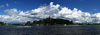
Cape Vincent is a village in Jefferson County, New York, United States. The population was 726 at the 2010 census. The village is in the west-central part of the town of Cape Vincent and is northwest of Watertown.

Cape Vincent is a town in Jefferson County, New York, United States. The population was 2,765 at the 2020 census.

Clayton is a village in the town of Clayton in Jefferson County, New York, United States. The village population was 1,705 at the 2020 census.

Watertown is a town in Jefferson County, New York, United States. The population was 5,913 at the 2020 census. The town is located in the central part of the county and borders the city of Watertown to the south, east, and west. As the city has a population of 24,685, or four times the town's population, references to "Watertown, New York", usually apply to the city rather than the town.

References

  1. "ArcGIS REST Services Directory". United States Census Bureau. Retrieved September 20, 2022.
  2. 1 2 "Geographic Identifiers: 2010 Census Summary File 1 (G001): Glen Park village, New York". American Factfinder. U.S. Census Bureau. Archived from the original on February 13, 2020. Retrieved September 13, 2018.
  3. "US Gazetteer files: 2010, 2000, and 1990". United States Census Bureau. February 12, 2011. Retrieved April 23, 2011.
  4. "Census of Population and Housing". Census.gov. Retrieved June 4, 2015.
  5. "U.S. Census website". United States Census Bureau . Retrieved January 31, 2008.