Amenia (town), New York

Last updated

Amenia, New York
Amenia, NY, town hall.jpg
Town hall
Amenia, NY Logo.png
Dutchess County New York incorporated areas Amenia highlighted.svg
Location of Amenia, New York
Coordinates: 41°50′49″N73°33′17″W / 41.84694°N 73.55472°W / 41.84694; -73.55472
Country United States
State New York
County Dutchess
Government
  Type Town Council
   Town Supervisor Victoria A. Perotti (R)
Area
[1]
  Total43.62 sq mi (112.96 km2)
  Land43.22 sq mi (111.94 km2)
  Water0.40 sq mi (1.03 km2)
Elevation
[2]
568 ft (173 m)
Population
 (2020)
  Total3,769
Time zone UTC-5 (Eastern (EST))
  Summer (DST) UTC-4 (EDT)
ZIP code
12501
Area code 845
FIPS code 36-027-01693
GNIS feature ID0942425 [2]
Website www.ameniany.gov

Amenia is a town in Dutchess County, New York, United States. The population was 3,769 at the 2020 census, [3] down from 4,436 at the 2010 census. [4] The town is on the eastern border of the county.

Contents

History

Amenia is one of the original towns formed by act of March 7, 1788. It comprises the width of the Oblong Tract, and the east tier of lots in the Great Nine Partners Patent.

Inhabitants prior to European incursion were Pequot, in a village on the west side of a pond they called Wequagnoch. Along with related Native Americans from Connecticut, they held pow wows on land both before and after the incorporation of the town. [5] [lower-alpha 1]

In 1703 Richard Sackett was granted a patent for land along Wassaic Creek. As this land was already included in the previous Great Nine Partners Patent, Sackett's title was invalid. Sackett was also one of the partners in the Little Nine Partners Patent. [5] He settled about one mile south of Wassaic at a site called the "Steel Works", as furnace and foundry were established there during the Revolution to manufacture steel for the use of the army. There was a forge at that location as early as 1770. [6]

In 1724 Captain Garret Winegar (Winnegar) came to Amenia Union from East Camp in Columbia County, New York. The Winegars were among the Palatine families from the Middle Rhine that had settled in the Province of New York in 1710 under the sponsorship of Queen Anne. [5] A second Palatine family, that of Johannes Rouh (Rowe), came to Hitchcock's Corner (Amenia Union) sometime prior to 1731. Samuel Hitchcock, for whom the hamlet was named, arrived in about 1757. Dr. Thomas Young lived at the "Corner" for several years and married a daughter of Captain Winegar. [7] The town was named by Young, [8] derived from Latin and meaning "pleasant to the eye". [9]

The house of worship known as the "Red Meeting House" was built in 1758, and stood about a mile northeast of the village of Amenia. George Whitefield preached there in the summer of 1770. The Precinct of Amenia was established by act of the colonial legislature in 1762.

In the summer of 1778, a large number of prisoners - mostly Hessians, taken at the battle of Saratoga the year before - were marched through the town on their way to Fishkill Landing, where they crossed the Hudson. It is said that some of the Hessian soldiers solicited the people to aid them in escaping; a few succeeded, and remained in this country.

Jacob Bockee, a captain in the company in Col. Willet's Regiment, was a member of the Assembly in 1795 and 1797, where he introduced a bill for the abolition of slavery in the state. Most of the slaves in the town were manumitted in the manner and under the conditions prescribed by law. Owners were not permitted to make free and cast off any slave who was not capable of providing for himself. In 1824, three years before the institutional abolition of slavery in the state, there were 32 slaves in Amenia. [6]

About the year 1812, a company was organized in this town for the manufacture of woolen goods, styled as the "Amenia Manufacturing Company" and owned by the Barker, Benton, Ingraham, Park, and Canfield families. Its factory was located on the banks of Webatuck Creek at Leedsville. [6]

Amenia was officially named a town, in separation from the eponymous presinct, in 1788. [10]

Geography

According to the United States Census Bureau, the town has a total area of 43.6 square miles (113.0 km2), of which 43.2 square miles (111.9 km2) is land and 0.39 square miles (1.0 km2), or 0.91%, is water. [4] The town is drained by the Ten Mile River, a tributary of the Housatonic River. The Ten Mile River is formed in the southern part of the town by the confluence of Wassaic Creek (draining the western part of the town) and Webatuck Creek (draining the eastern part).

The eastern town line is the border of Connecticut. U.S. Route 44 crosses the northern part of the town.

Demographics

Historical population
CensusPop.Note
1820 3,114
1830 2,389−23.3%
1840 2,179−8.8%
1850 2,2292.3%
1860 2,2882.6%
1870 2,66216.3%
1880 2,6971.3%
1890 2,362−12.4%
1900 2,3740.5%
1910 2,123−10.6%
1920 1,831−13.8%
1930 1,9697.5%
1940 6,873249.1%
1950 7,4818.8%
1960 7,5460.9%
1970 7,8423.9%
1980 6,299−19.7%
1990 5,195−17.5%
2000 4,048−22.1%
2010 4,4369.6%
2020 3,769−15.0%
U.S. Decennial Census [11] 2020 [12]

As of the census [13] of 2000, there were 4,048 people, 1,625 households, and 1,074 families residing in the town. The population density was 93.5 inhabitants per square mile (36.1/km2). There were 1,814 housing units at an average density of 41.9 per square mile (16.2/km2). The racial makeup of the town was 93.40% White, 2.94% Black or African American, 0.59% Native American, 0.47% Asian, 0.77% from other races, and 1.83% from two or more races. Hispanic or Latino of any race were 3.36% of the population.

Silo Ridge Country Club in Amenia Silo Ridge Country Club.JPG
Silo Ridge Country Club in Amenia

There were 1,625 households, out of which 29.4% had children under the age of 18 living with them, 51.4% were married couples living together, 9.8% had a female householder with no husband present, and 33.9% were non-families. 27.9% of all households were made up of individuals, and 13.0% had someone living alone who was 65 years of age or older. The average household size was 2.46 and the average family size was 2.97.

In the town, the population was spread out, with 23.7% under the age of 18, 6.5% from 18 to 24, 27.6% from 25 to 44, 25.0% from 45 to 64, and 17.1% who were 65 years of age or older. The median age was 40 years. For every 100 females, there were 95.6 males. For every 100 females age 18 and over, there were 91.6 males.

The median income for a household in the town was $39,231, and the median income for a family was $51,294. Males had a median income of $32,038 versus $28,769 for females. The per capita income for the town was $22,095. About 3.4% of families and 8.1% of the population were below the poverty line, including 2.0% of those under age 18 and 12.7% of those age 65 or over.

Education

Primary and secondary schools

The Webutuck Central Schools District serves the town of Amenia. [14] The district serves pre-kindergarten to twelfth grade. Schools include Webutuck Elementary School, Eugene Brooks Intermediate School and Webutuck High School. [15]

Two private schools serving the town are Maplebrook School and The Kildonan School. Maplebrook School is a small boarding school serving adolescents and young adults with learning differences. [16] The Kildonan School is a boarding and day school exclusively for students with dyslexia and language based learning differences. [17]

Library

The Amenia Free Library serves Amenia. The library was founded in 1938 and has a collection of rare historical books. [18]

Infrastructure

Transportation

The main thoroughfare of Amenia is New York State Route 22. State Route 22 runs through every town on the east side of Dutchess County. U.S. Route 44 also passes through Amenia, intersecting Route 22 within the hamlet of Amenia. Metro-North Railroad has two rail commuter rail stations in Amenia, with service to New York City via the Harlem Line. The Tenmile River station is off Sinpatch Road east of Route 22, and the Wassaic station is 2 miles (3 km) north of Tenmile River. Trains leave every two hours during midday, evenings and weekends. In rush hour, peak-direction trains leave about every 30 minutes. There is no train service into or out of Amenia after midnight.

In 2006, the NYSDOT administered the repaving of Route 22 through the town of Dover, New York. The prime contractor was Callanan Industries, Inc., an Albany, New York based contractor. In 2007, repaving continued north from the town line into Amenia, New York with two other contractors - Peckham Road Corp. for paving in Wassaic and A. Colarusso & Son Inc., a Hudson, New York based contractor for the portion north of Wassaic.

Notable people

Communities and locations in Amenia

Buildings in Amenia listed on the National Register of Historic Places

Buildings in Amenia listed on the National Register of Historic Places include:

Notes

  1. Contemporary research says that the Native Americans living on this land when Europeans arrived are more likely to have been Munsee Lenape, Mohican, and/or Schaghticoke. See Native Land

Related Research Articles

<span class="mw-page-title-main">Dutchess County, New York</span> County in New York, United States

Dutchess County is a county in the U.S. state of New York. As of the 2020 census, the population was 295,911. The county seat is the city of Poughkeepsie. The county was created in 1683, one of New York's first twelve counties, and later organized in 1713. It is located in the Mid-Hudson Region of the Hudson Valley, north of New York City.

Ashford is a town in Cattaraugus County, New York, United States. The population was 1,974 at the 2020 census. The town is on the county's northern border.

<span class="mw-page-title-main">Clinton, Dutchess County, New York</span> Town in New York, United States

Clinton is a town in Dutchess County, New York, United States. The population was 4,037 in the 2020 census, down from 4,312 in the 2010 census.

<span class="mw-page-title-main">Dover, New York</span> Town in New York, United States

Dover is a town in Dutchess County, New York, United States. The population was 8,415 at the 2020 census. The town was named after Dover in England, the home town of an early settler.

<span class="mw-page-title-main">Hillside Lake, New York</span> Census-designated place in New York, United States

Hillside Lake is a hamlet and census-designated place (CDP) in Dutchess County, New York, United States. The population was 1,084 at the 2010 census. It is part of the Poughkeepsie–Newburgh–Middletown, NY Metropolitan Statistical Area as well as the larger New York–Newark–Bridgeport, NY-NJ-CT-PA Combined Statistical Area.

<span class="mw-page-title-main">LaGrange, New York</span> Town in New York, United States

LaGrange is a town in Dutchess County, New York, United States. The population was 15,975 at the 2020 census. The town was named after the estate of the Marquis de Lafayette.

<span class="mw-page-title-main">North East, New York</span> Town in New York, United States

North East is a town in Dutchess County, New York, United States. The population was 3,031 at the 2020 census. The town is in the northeastern corner of the county. U.S. Route 44 crosses the town.

<span class="mw-page-title-main">Stanford, New York</span> Town in New York, United States

Stanford is a town in the north-central part of Dutchess County, New York, United States. The population was 3,628 at the 2020 census, down from 3,823 at the 2010 census.

<span class="mw-page-title-main">Washington, New York</span> Town in Dutchess County, New York, US

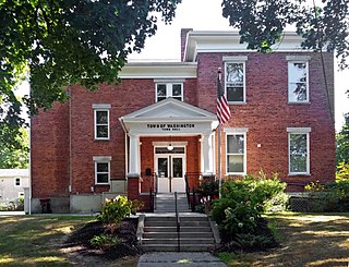
Washington is a town in Dutchess County, New York, United States. The population was 4,522 at the 2020 census. The town is named after George Washington, who passed through the town during the Revolution.

<span class="mw-page-title-main">Southeast, New York</span> Town in New York, United States

Southeast is a town in Putnam County, New York, United States, so named for its location in the southeastern corner of the county. The population was 18,058 at the 2020 census. The town as a whole is informally referred to as Brewster, the town's principal settlement; the latter is also an incorporated village within the town's borders. Interstate 84, Interstate 684, U.S. Route 202, US Route 6, and NY 22 are the primary routes through the town.

<span class="mw-page-title-main">Amenia (CDP), New York</span> Hamlet in the state of New York, United States

Amenia is a hamlet and census-designated place (CDP) in Dutchess County, New York, United States. The population was 725 at the 2020 census. It is part of the Poughkeepsie–Newburgh–Middletown, NY Metropolitan Statistical Area as well as the larger New York–Newark–Bridgeport, NY-NJ-CT-PA Combined Statistical Area.

<span class="mw-page-title-main">Poughkeepsie (town), New York</span> Town in New York, United States

Poughkeepsie, officially the Town of Poughkeepsie, is a town in Dutchess County, New York, United States. As of the 2020 United States Census, the population was 45,471. The name is derived from the native term Uppuqui meaning "lodge-covered", plus ipis meaning "little water", plus ing meaning "place", all of which translates to "the reed-covered lodge by the little water place", or Uppuqui-ipis-ing. This later evolved into Apokeepsing, then into Poughkeepsing, and finally Poughkeepsie.

<span class="mw-page-title-main">Wassaic station</span> Metro-North Railroad station in New York

Wassaic station is a commuter rail stop on the Metro-North Railroad's Harlem Line, located in the town of Amenia, New York. It is the northern terminal of the Harlem Line.

<span class="mw-page-title-main">Wassaic, New York</span> Hamlet and CDP in New York, United States

Wassaic is a hamlet and census-designated place in the town of Amenia, Dutchess County, New York, United States. As of the 2020 census, its population in 210. Located in southeastern New York in the valley of the Ten Mile River, Wassaic is bordered to the east and west by mountain ranges.

<span class="mw-page-title-main">State Route 343 (New York−Connecticut)</span> Highway in New York and Connecticut

New York State Route 343 (NY 343) is a state highway located entirely within central Dutchess County, in the Hudson Valley region of the U.S. state of New York. It runs east–west from the intersection of NY 82 in the village of Millbrook to the town of Amenia, where it crosses the Connecticut state line and continues eastward as Route 343, a Connecticut state highway located entirely within the town of Sharon. Along the way, it has a 7.3-mile (11.7 km) concurrency with NY 22 from vicinity of the hamlet of Dover Plains to the hamlet of Amenia.

<span class="mw-page-title-main">Ten Mile River (Housatonic River tributary)</span>

The Ten Mile River is a 15.4-mile-long (24.8 km) river that flows through Dutchess County, New York, into westernmost Connecticut. The river is formed in the town of Amenia, New York, at the confluence of Webatuck Creek and Wassaic Creek. The Ten Mile River runs south through the town of Dover, New York before turning east and crossing into Connecticut, where it forms the boundary between the towns of Kent and Sherman for one-half mile before flowing into the Housatonic River. This is a popular whitewater paddling destination with mostly quickwater and a few whitewater areas reaching up to Class III.

<span class="mw-page-title-main">Indian Rock Schoolhouse</span> United States historic place

Indian Rock Schoolhouse, also known as District 3 Schoolhouse or Webutuck Country Schoolhouse, is located on Mygatt Road in the hamlet of Amenia, New York, United States. It is a wooden one-room schoolhouse built in the mid-19th century in accordance with a standard state plan for small rural schools that reflected contemporary educational reform movements.

<span class="mw-page-title-main">Hyde Park (CDP), New York</span> Census-designated place in New York, United States

Hyde Park is a hamlet and census-designated place (CDP) in the town of Hyde Park, Dutchess County, New York, United States. Its population was 1,908 as of the 2010 census.

<span class="mw-page-title-main">U.S. Route 44</span> Highway in the United States

U.S. Route 44 (US 44) is an east–west United States Numbered Highway that runs for 237 miles (381 km) through four states in the Northeastern United States. The western terminus is at US 209 and New York State Route 55 (NY 55) in Kerhonkson, New York, a hamlet in the Hudson Valley region. The eastern terminus is at Route 3A in Plymouth, Massachusetts.

MacDonnell Heights is a census-designated place (CDP) in the town of Poughkeepsie in Dutchess County, New York, United States. It was first listed as a CDP prior to the 2020 census.

References

  1. "2016 U.S. Gazetteer Files". United States Census Bureau. Retrieved July 4, 2017.
  2. 1 2 U.S. Geological Survey Geographic Names Information System: Amenia (town), New York
  3. US Census Bureau, 2020 Census Report, Amenia town, Dutchess County, New York https://www.census.gov/search-results.html?searchType=web&cssp=SERP&q=Amenia%20town,%20Dutchess%20County,%20New%20York Accessed December 29, 2022
  4. 1 2 "Geographic Identifiers: 2010 Demographic Profile Data (G001): Amenia town, Dutchess County, New York". U.S. Census Bureau, American Factfinder. Archived from the original on February 13, 2020. Retrieved November 10, 2015.
  5. 1 2 3 Reed, Newton. Early History of Amenia, De Lace & Wiley, Amenia, NY, 1875
  6. 1 2 3 Smith, Philip H., "History of Amenia, NY", General History of Dutchess County, 1877
  7. "A Brief History of Amenia Union", Sharon Historical Society
  8. Smith, James H. "Town of Amenia", History of Dutchess County, D. Mason & Company, Syracuse, 1882
  9. "Amenia". ePodunk. Retrieved May 6, 2014.
  10. Reed, Newton (2010). Early History of Amenia. Applewood Books. p. 45. ISBN   9781429023108.
  11. "Census of Population and Housing". Census.gov. Retrieved June 4, 2015.
  12. US Census Bureau, 2020 Census Report, Amenia town, Dutchess County, New York https://www.census.gov/search-results.html?searchType=web&cssp=SERP&q=Amenia%20town,%20Dutchess%20County,%20New%20York Accessed December 29, 2022
  13. "U.S. Census website". United States Census Bureau . Retrieved January 31, 2008.
  14. "Webutuck Central School District". Webutuck Central School District. Retrieved May 6, 2014.[ permanent dead link ]
  15. "Webutuck Schools". Webutuck Central School District. Retrieved April 9, 2024.
  16. "Maplebrook School". Maplebrook School. Retrieved May 6, 2014.
  17. "The Kildonan School". The Kildonan School. Retrieved May 6, 2014.
  18. "Amenia Public Library". Amenia Free Library. Retrieved May 6, 2014.
  19. "Peru, Oxford, Maine Genealogy Project". Ancestry.com. Retrieved May 7, 2014.
  20. Adams, Arthur G. (1988). The Hudson River in Literature: An Anthology. Fordham Univ Press. p. 321. ISBN   9780823212026.
  21. "Gail Borden". Today in Science History. Retrieved May 9, 2014.
  22. "Behind the Gates of Silo Ridge—the Country's Most Exclusive New Residential Enclave". Architectural Digest. Retrieved August 28, 2019.
  23. 1 2 3 4 "Amenia, NY". Tri-State Chamber of Commerce. Archived from the original on May 7, 2014. Retrieved May 6, 2014.
  24. "Wesleyan's Fifth President". Wesleyan University. Retrieved May 9, 2014.
  25. 1 2 3 Who Was Who in America, Historical Volume, 1607-1896. Chicago: Marquis Who's Who. 1963.
  26. "Joel Elias Spingarn Papers (PP)". The New York Botanical Garden. Archived from the original on October 17, 2007. Retrieved May 9, 2014.
  27. "SWIFT, Benjamin, (1781 - 1847)". Biographical Directory of the United States Congress. Retrieved May 6, 2014.
  28. John Ferro (February 6, 2016). "At Silo Ridge, concerns over water, views and bullets". www.poughkeepsiejournal.com. Retrieved June 20, 2020.


41°50′49″N73°33′17″W / 41.84694°N 73.55472°W / 41.84694; -73.55472