Brecknock Township, Lancaster County, Pennsylvania

Last updated

Brecknock Township,
Lancaster County,
Pennsylvania
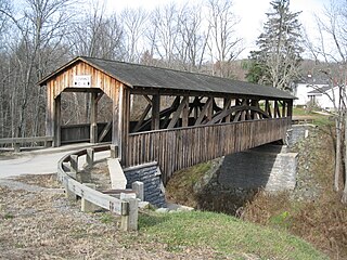
Red Run Covered Bridge Three Quarters View 3008px.jpg
Red Run Covered Bridge (1866)
National Register of Historic Places
Brecknock Township, Lancaster County Highlighted.png
Map of Lancaster County highlighting Brecknock Township
Country United States
State Pennsylvania
County Lancaster
Settled1730
Incorporated1740
Government
  TypeBoard of Supervisors
Area
[1]
  Total24.87 sq mi (64.40 km2)
  Land24.65 sq mi (63.84 km2)
  Water0.22 sq mi (0.57 km2)
Population
 (2020) [2]
  Total7,585 Increase2.svg
  Estimate 
(2021) [2]
7,598
  Density302.96/sq mi (116.97/km2)
Time zone UTC-5 (Eastern (EST))
  Summer (DST) UTC-4 (EDT)
Area code 717
FIPS code 42-071-08352
Website brecknocktownship.us

Brecknock Township is a township in northeastern Lancaster County, Pennsylvania, United States. The population was 7,585 at the 2020 census. [2]

Contents

History

Brecknock is a Welsh name. [3]

The Bowmansville Roller Mill, John B. Good House, and Red Run Covered Bridge are listed on the National Register of Historic Places. [4]

Geography

According to the United States Census Bureau, the township has a total area of 24.9 square miles (64 km2), of which 24.9 square miles (64 km2) is land and 0.04% is water. It includes the communities of Bowmansville, Fivepointville, and Red Run.

Recreation

Portions of the Pennsylvania State Game Lands Number 52 are located in the township. [5] [6]

Demographics

Historical population
CensusPop.Note
1980 4,068
1990 5,19727.8%
2000 6,69928.9%
2010 7,1997.5%
2020 7,5855.4%
2021 (est.)7,598 [2] 0.2%
U.S. Decennial Census [7]

As of the census [8] of 2000, there were 6,699 people, 2,115 households, and 1,793 families living in the township. The population density was 268.8 inhabitants per square mile (103.8/km2). There were 2,161 housing units at an average density of 86.7 per square mile (33.5/km2). The racial makeup of the township was 97.70% White, 0.33% African American, 0.15% Native American, 0.75% Asian, 0.03% Pacific Islander, 0.30% from other races, and 0.75% from two or more races. Hispanic or Latino of any race were 0.96% of the population.

There were 2,115 households, out of which 42.1% had children under the age of 18 living with them, 76.1% were married couples living together, 5.5% had a female householder with no husband present, and 15.2% were non-families. 13.2% of all households were made up of individuals, and 5.6% had someone living alone who was 65 years of age or older. The average household size was 3.17 and the average family size was 3.48.

In the township the population was spread out, with 33.0% under the age of 18, 8.0% from 18 to 24, 27.6% from 25 to 44, 20.7% from 45 to 64, and 10.7% who were 65 years of age or older. The median age was 33 years. For every 100 females, there were 101.8 males. For every 100 females age 18 and over, there were 98.2 males.

The median income for a household in the township was $51,505, and the median income for a family was $53,329. Males had a median income of $36,210 versus $22,652 for females. The per capita income for the township was $18,578. About 5.1% of families and 8.8% of the population were below the poverty line, including 15.7% of those under age 18 and 4.6% of those age 65 or over.

Related Research Articles

<span class="mw-page-title-main">East Earl Township, Pennsylvania</span> Township in Pennsylvania, United States

East Earl Township is a township in northeastern Lancaster County, Pennsylvania, United States. At the 2020 census, the population was 6,721.

<span class="mw-page-title-main">Eden Township, Pennsylvania</span> Township in Pennsylvania, United States

Eden Township is a township in southeastern Lancaster County, Pennsylvania, United States. At the 2020 census, the population was 2,248. It is part of the Solanco School District.

<span class="mw-page-title-main">Greenbush Township, Clinton County, Michigan</span> Civil township in Michigan, United States

Greenbush Township is a civil township of Clinton County in the U.S. state of Michigan. The population was 2,143 at the 2020 census.

<span class="mw-page-title-main">Berwick Township, Pennsylvania</span> Township in Pennsylvania, United States

Berwick Township is a township in Adams County, Pennsylvania, United States. The population was 2,403 at the 2020 census. Berwick Township is one of 21 townships in Adams County.

<span class="mw-page-title-main">Brecknock Township, Berks County, Pennsylvania</span> Township in Pennsylvania, United States

Brecknock Township is a township in Berks County, Pennsylvania, United States. The population was 4,618 at the 2020 census.

<span class="mw-page-title-main">Caernarvon Township, Berks County, Pennsylvania</span> Township in Pennsylvania, United States

Caernarvon Township is a township in Berks County, Pennsylvania, United States. The population was 4,252 at the 2020 census. It is often referred to as Morgantown, the township's largest village.
<span class="mw-page-title-main">Burlington Township, Pennsylvania</span> Township in Pennsylvania, United States

Burlington Township is a township in Bradford County, Pennsylvania, United States. It is part of Northeastern Pennsylvania. The population was 791 at the 2010 census. Children residing in the township are assigned to attend the Troy Area School District.

<span class="mw-page-title-main">Wells Township, Bradford County, Pennsylvania</span> Township in Pennsylvania, United States

Wells Township is a township in Bradford County, Pennsylvania. It is part of Northeastern Pennsylvania. The population was 814 at the 2010 census.

<span class="mw-page-title-main">Boggs Township, Clearfield County, Pennsylvania</span> Township in Pennsylvania, United States

Boggs Township is a township in Clearfield County, Pennsylvania, United States. The population was 1,666 at the 2020 census.

<span class="mw-page-title-main">Briar Creek Township, Pennsylvania</span> Township in Pennsylvania, United States

Briar Creek Township is a township in Columbia County, Pennsylvania. It is part of Northeastern Pennsylvania. The population was 2,992 at the 2020 census.

<span class="mw-page-title-main">Rutherford, Pennsylvania</span> Census-designated place in Pennsylvania, United States

Rutherford is a census-designated place (CDP) in Swatara Township, Dauphin County, Pennsylvania, United States. The area is also known as Rutherford Heights. The population was 4,303 at the 2010 census, an increase over the figure of 3,859 tabulated in 2000. It is part of the Harrisburg–Carlisle Metropolitan Statistical Area.

<span class="mw-page-title-main">Highland Township, Elk County, Pennsylvania</span> Township in Pennsylvania, United States

Highland Township is a township in Elk County, Pennsylvania, United States. The population was 398 at the 2020 census, down from 492 in 2010.

<span class="mw-page-title-main">East Hanover Township, Lebanon County, Pennsylvania</span> Township in Pennsylvania, United States

East Hanover Township is a township in Lebanon County, Pennsylvania, United States. The population was 2,801 at the 2010 census. It is part of the Lebanon, PA Metropolitan Statistical Area.

<span class="mw-page-title-main">Millcreek Township, Lebanon County, Pennsylvania</span> Township in Pennsylvania, United States

Millcreek Township is a township in Lebanon County, Pennsylvania, United States. The population was 4,350 at the 2020 census. It is part of the Lebanon, Pennsylvania Metropolitan Statistical Area.

<span class="mw-page-title-main">West Cornwall Township, Pennsylvania</span> Township in Pennsylvania, United States

West Cornwall Township is a township in Lebanon County, Pennsylvania, United States. It is part of the Lebanon, PA Metropolitan Statistical Area. The population was 1,987 at the 2020 census.

<span class="mw-page-title-main">Delaware Township, Northumberland County, Pennsylvania</span> Township in Pennsylvania, United States

Delaware Township is a township in Northumberland County, Pennsylvania, United States. The population at the 2020 Census was 4,303, a decrease from the figure of 4,489 tabulated in 2010.

<span class="mw-page-title-main">Blythe Township, Pennsylvania</span> Township in Pennsylvania, United States

Blythe Township is a township in Schuylkill County, Pennsylvania. Formed in 1846 from part of Schuylkill Township, it is named for State Legislator Calvin Blythe.

<span class="mw-page-title-main">Washington Township, Schuylkill County, Pennsylvania</span> Township in Pennsylvania, United States

Washington Township is a township that is located in Schuylkill County, Pennsylvania, United States. The population was 3,134 at the time of the 2020 census.

<span class="mw-page-title-main">Conewago Township, York County, Pennsylvania</span> Township in Pennsylvania, United States

Conewago Township is a township in York County, Pennsylvania, United States. The township encompasses the land between the Conewago Creek and the Little Conewago Creek, west of their conjunction. The township was formed in 1818 from the northeastern portion of Dover Township and the southeastern portion of Newberry Township and consists of approximately 11,000 acres. The population was 8,527 at the 2020 census.

<span class="mw-page-title-main">Paradise Township, York County, Pennsylvania</span> Township in Pennsylvania, United States

Paradise Township is a settlement in York County, Pennsylvania, United States. As of the 2020 census, the township population was 3,966.

References

  1. "2016 U.S. Gazetteer Files". United States Census Bureau. Retrieved August 14, 2017.
  2. 1 2 3 4 Bureau, US Census. "City and Town Population Totals: 2020-2021". Census.gov. US Census Bureau. Retrieved July 9, 2022.
  3. "Brecknock Township's Interesting History". Reading Eagle . May 1, 1914. p. 17. Retrieved April 23, 2015.
  4. "National Register Information System". National Register of Historic Places . National Park Service. July 9, 2010.
  5. https://viewer.nationalmap.gov/advanced-viewer/ Archived October 29, 2017, at the Wayback Machine The National Map, retrieved October 24, 2018
  6. Pennsylvania State Game Lands Number 52, retrieved October 25, 2018
  7. "Census of Population and Housing". Census.gov. Retrieved June 4, 2016.
  8. "U.S. Census website". United States Census Bureau . Retrieved January 31, 2008.

40°11′44″N76°02′09″W / 40.19556°N 76.03583°W / 40.19556; -76.03583