Related Research Articles

Bigler Township is a township in Clearfield County, Pennsylvania, United States. The population was 1,242 at the 2020 census.

Woodsdale is an unincorporated community in Madison and St. Clair Townships in central Butler County, Ohio, United States, about three miles northeast of Hamilton. It was established in 1867 by the Beckett Paper Company and was formerly a stop on the Cincinnati, Hamilton, and Dayton Railroad. An electric generation plant of the Cincinnati Gas and Electric Company is located in Woodsdale. Woodsdale is also the location of the Samuel Augspurger House & Farm and The Augspurger Schoolhouse both of which are on the National Register of Historic Places. Woodsdale was also known for the Woodsdale Island Amusement Park.
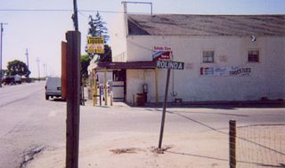
Rolinda is a small unincorporated agricultural community in Fresno County, California, United States. It is located on the Southern Pacific Railroad 10 miles (16 km) west of downtown Fresno, at an elevation of 253 feet. It is located along State Route 180. Official U.S. Geological Survey coordinates for the community are 36°44′07″N119°57′43″W. The community is in area code 559. It does not have its own ZIP code and mail uses the Fresno ZIP code of 93706.

Tucquan Creek is a 5.9-mile-long (9.5 km) stream and tributary of the Susquehanna River near Holtwood in southern Lancaster County, Pennsylvania. Together with parts of Clark Run and Tucquan Glen it is a designated Pennsylvania Scenic River. The Tucquan Glen hiking trail goes along both sides of the creek, starting from River Road and ending at the railroad tracks along the Susquehanna. In addition to the rugged loop trail, is a relatively flat dirt road going along and often crossing the creek to said railroad tracks.

The Harrisburg Subdivision is a railroad line owned by CSX Transportation in Pennsylvania. The line is located in Philadelphia, and connects Greenwich Yard and the Philadelphia Subdivision with the Trenton Subdivision along a former Pennsylvania Railroad line. Much of the Harrisburg Subdivision is the High Line' or West Philadelphia Elevated along 31st Street over the 30th Street Station area.

Pennsylvania's 19th congressional district was a congressional district that became obsolete for the 113th Congress in 2013, due to Pennsylvania's slower population growth compared to the rest of the nation.

Lapidum is a ghost town in Harford County, Maryland, USA, located at the head of navigation of the Susquehanna River on the west bank across from Port Deposit.
Əfəndilər is a village in the Jabrayil Rayon of Azerbaijan.
Qazançı is a village in the Zangilan District of Azerbaijan.
Creswell is an unincorporated community in Harford County, Maryland, United States. Fair Meadows was listed on the National Register of Historic Places in 1980.
Woodbine is an unincorporated community in York County, Pennsylvania, United States. Until 1978, this community was served by the Maryland and Pennsylvania Railroad at milepost 50.6.
Tolna is an unincorporated community in York County, Pennsylvania, United States. Tolna is located near Pennsylvania Route 851.
Bryansville is an unincorporated community in York County, Pennsylvania, United States. The village of Bryansville has a large residential area, known as Susquehanna Trails, almost adjacent to it. Until 1978, this community was served by the Maryland and Pennsylvania Railroad at milepost 45.9.
Creswell High School was a public high school located in Creswell, North Carolina. It was one of two high schools, along with Plymouth High School, in Washington County Schools. Creswell High School served grades 6–12. Creswell High School's enrollment as of 2010 was 161 students. The student body was 52% Black; 39% White; 5% Hispanic; and 4% Unknown. All Creswell students received a free or reduced lunch. It was shut down following the class of 2018 as the county made room for Washington County High School. The shutdown of Creswell High lost the county a total of 44 students to neighboring county school systems, a large portion of the small school.
Violet Hill is an unincorporated area in York County, Pennsylvania, United States. This community, which is located in Spring Garden Township, is a suburb of the city of York.
Admire is an unincorporated community in York County, Pennsylvania, United States.

Mount Laguna Air Force Station is a closed United States Air Force General Surveillance Radar station. It is located 24.3 miles (39.1 km) north-northeast of Tecate, California. It was closed in 1981 by the Air Force, and turned over to the Federal Aviation Administration (FAA).
Davidsburg is an unincorporated community in York County, Pennsylvania, United States. Davidsburg is located in Dover Township, three miles west of Weigelstown.
Bandanna, also known as Pleasant Hill, is an unincorporated area in York County, Pennsylvania, United States. Bandanna is located on Pennsylvania Route 94, approximately three miles south of Hanover.
Henleyville is an unincorporated community in Tehama County, in the U.S. state of California.
References

39°57′43″N76°26′04″W / 39.96194°N 76.43444°W
| | This Lancaster County, Pennsylvania state location article is a stub. You can help Wikipedia by expanding it. |