Salisbury Township, Lancaster County, Pennsylvania

Last updated

Salisbury Township,
Lancaster County, Pennsylvania
Bart Friends meeting LanCo PA 1.jpg
Bart Friends Meeting House in Salisbury Township
Salisbury Township, Lancaster County Highlighted.png
Location of Salisbury Township in Lancaster County, Pennsylvania
Country United States
State Pennsylvania
County Lancaster
Settled1712
Incorporated1729
Government
  TypeBoard of Supervisors
Area
[1]
  Total41.95 sq mi (108.64 km2)
  Land41.76 sq mi (108.16 km2)
  Water0.19 sq mi (0.49 km2)
Population
 (2020) [2]
  Total11,531 Increase2.svg
  Estimate 
(2021) [2]
11,483
  Density273.18/sq mi (105.48/km2)
Time zone UTC-5 (Eastern (EST))
  Summer (DST) UTC-4 (EDT)
Area code 717
FIPS code 42-071-67568
Website www.salisburytownship.org

Salisbury Township is a township in east central Lancaster County, Pennsylvania, United States. The population was 11,531 at the 2020 census. [2]

Contents

History

White Chimneys in Salisbury Township White Chimneys.JPG
White Chimneys in Salisbury Township
Near White Horse in the township Approaching White Horse, PA.jpg
Near White Horse in the township

Salisbury Township was carved out of Pequea Township in 1729 and named for Salisbury, England. Though still mostly agricultural, it has been a center of commerce and industry of Lancaster County, with nickel mining beginning in 1718 and a more profitable limestone mining beginning soon after.

White Chimneys was listed on the National Register of Historic Places in 1975. [3]

Geography

According to the U.S. Census Bureau, the township has a total area of 41.9 square miles (108.4 km2), all of which is land. Unincorporated communities in the township include Mountain Top, South Hermitage, Mount Airy, Springville, Spring Garden, Salisbury Heights, White Horse, Cains, Buena Vista, Buyerstown, Jacksonville, Gap, Limeville, and parts of Cambridge and New Milltown.

Demographics

Historical population
CensusPop.Note
2000 10,012
2010 11,06210.5%
2020 11,5314.2%
2021 (est.)11,483 [2] −0.4%
U.S. Decennial Census [4]

At the 2000 census there were 10,012 people, 3,027 households, and 2,530 families living in the township. The population density was 239.2 inhabitants per square mile (92.4/km2). There were 3,112 housing units at an average density of 74.4 per square mile (28.7/km2). The racial makeup of the township was 97.47% White, 0.76% African American, 0.12% Native American, 0.49% Asian, 0.04% Pacific Islander, 0.34% from other races, and 0.78% from two or more races. Hispanic or Latino of any race were 1.08%. [5]

There were 3,027 households, 44.5% had children under the age of 18 living with them, 74.2% were married couples living together, 5.7% had a female householder with no husband present, and 16.4% were non-families. 13.7% of households were made up of individuals, and 5.5% were one person aged 65 or older. The average household size was 3.29 and the average family size was 3.64.

The age distribution was 34.8% under the age of 18, 8.6% from 18 to 24, 27.8% from 25 to 44, 20.2% from 45 to 64, and 8.5% 65 or older. The median age was 30 years. For every 100 females, there were 102.5 males. For every 100 females age 18 and over, there were 99.4 males.

The median household income was $45,795 and the median family income was $49,623. Males had a median income of $36,644 versus $22,153 for females. The per capita income for the township was $16,268. About 7.1% of families and 9.3% of the population were below the poverty line, including 11.6% of those under age 18 and 15.2% of those age 65 or over.

Related Research Articles

<span class="mw-page-title-main">Conestoga Township, Pennsylvania</span> Township in Pennsylvania, United States

Conestoga Township is a township in west central Lancaster County, Pennsylvania. At the 2020 census, the population was 3,922.

<span class="mw-page-title-main">Conoy Township, Pennsylvania</span> Township in Pennsylvania, United States

Conoy Township is a township in northwestern Lancaster County, Pennsylvania, United States. At the 2020 census, the population was 3,373.

<span class="mw-page-title-main">Eden Township, Pennsylvania</span> Township in Pennsylvania, United States

Eden Township is a township in southeastern Lancaster County, Pennsylvania, United States. At the 2020 census, the population was 2,248. It is part of the Solanco School District.

<span class="mw-page-title-main">Fulton Township, Pennsylvania</span> Township in Pennsylvania, United States

Fulton Township is a township in southern Lancaster County, Pennsylvania, United States, and it is the only municipality in the county to touch the Maryland border. At the 2020 census the population was 3,227. It is part of the Solanco School District.

<span class="mw-page-title-main">Martic Township, Pennsylvania</span> Township in Pennsylvania, United States

Martic Township is a township in southwestern Lancaster County, Pennsylvania, United States. At the 2020 census, the population was 5,237. Martic Township was organized in 1729. It borders Conestoga, Providence, Pequea and Drumore townships.

<span class="mw-page-title-main">Standish Township, Michigan</span> Civil township in Michigan, United States

Standish Township is a civil township of Arenac County in the U.S. state of Michigan. The population was 1,701 at the 2020 census. The city of Standish borders the township on the northwest but is administered autonomously.

<span class="mw-page-title-main">Conewago Township, Adams County, Pennsylvania</span> Township in Pennsylvania, United States

Conewago Township is a township in Adams County, Pennsylvania, United States. The population was 7,875 at the 2020 census.

<span class="mw-page-title-main">Hamilton Township, Adams County, Pennsylvania</span> Township in Pennsylvania, United States

Hamilton Township is a township in Adams County, Pennsylvania, United States. The population was 2,714 at the 2020 census.

<span class="mw-page-title-main">Franklin Township, Fayette County, Pennsylvania</span> Township in Pennsylvania, United States

Franklin Township is a township in Fayette County, Pennsylvania, United States. The population was 2,380 at the 2020 census, a decline from the figure of 2,528 tabulated in 2010. The township is served by the Uniontown Area School District.

<span class="mw-page-title-main">Metal Township, Pennsylvania</span> Township in Pennsylvania, United States

Metal Township is a township that is located in Franklin County, Pennsylvania, United States. The population was 1,768 at the time of the 2020 census.

<span class="mw-page-title-main">Colerain Township, Lancaster County, Pennsylvania</span> Township in Pennsylvania, United States

Colerain Township is a township in southeastern Lancaster County, Pennsylvania, United States. The population was 3,883 at the 2020 census, an increase over the figure of 3,635 tabulated in 2010. It is part of the Solanco School District.

<span class="mw-page-title-main">Ephrata Township, Pennsylvania</span> Township in Pennsylvania, United States

Ephrata Township is a township in northeastern Lancaster County, Pennsylvania, United States. The population was 10,391 at the 2020 census.

<span class="mw-page-title-main">Paradise Township, Lancaster County, Pennsylvania</span> Township in Pennsylvania, United States

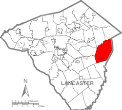
Paradise Township is a township that is located in east-central Lancaster County, Pennsylvania, United States. The population was 5,696 at the time of the 2020 census.

<span class="mw-page-title-main">Strasburg Township, Pennsylvania</span> Township in Pennsylvania, United States

Strasburg Township is a township in south central Lancaster County, Pennsylvania, United States. The population was 4,467 at the 2020 census.

<span class="mw-page-title-main">West Lampeter Township, Pennsylvania</span> Township in Pennsylvania, United States

West Lampeter Township is a township that is located in central Lancaster County, Pennsylvania, United States. The population was 17,365 at the time of the 2020 census.

<span class="mw-page-title-main">Mill Creek Township, Mercer County, Pennsylvania</span> Township in Pennsylvania, United States

Mill Creek Township is a township in Mercer County, Pennsylvania, United States. The population was 776 at the 2020 census, down from 721 in 2010.

<span class="mw-page-title-main">East Chillisquaque Township, Northumberland County, Pennsylvania</span> Township in Pennsylvania, United States

East Chillisquaque Township is a township in Northumberland County, Pennsylvania, United States. The population at the 2010 Census was 668, an increase over the figure of 664 tabulated in 2000.

<span class="mw-page-title-main">Carroll Township, York County, Pennsylvania</span> Township in Pennsylvania, United States

Carroll Township is a township in York County, Pennsylvania, United States. The population was 6,853 at the 2020 census.

<span class="mw-page-title-main">Heidelberg Township, York County, Pennsylvania</span> Township in Pennsylvania, United States

Heidelberg Township is a township in York County, Pennsylvania, United States. The township was erected in 1750 and encompassed the land grant known as Digges' Choice, a warrant granted to John Digges in 1727 by the colonial-era Province of Maryland, prior to the time the Mason-Dixon line fixed the final boundary between Maryland and Pennsylvania. The population of Heidelberg Township was 3,027 at the 2020 census.

<span class="mw-page-title-main">Washington Township, York County, Pennsylvania</span> Township in Pennsylvania, United States

Washington Township is a township in York County, Pennsylvania, United States. The population was 2,576 at the 2020 census. Kralltown is one of the township's unincorporated communities.

References

  1. "2016 U.S. Gazetteer Files". United States Census Bureau. Retrieved August 14, 2017.
  2. 1 2 3 4 Bureau, US Census. "City and Town Population Totals: 2020-2021". Census.gov. US Census Bureau. Retrieved July 9, 2022.
  3. "National Register Information System". National Register of Historic Places . National Park Service. July 9, 2010.
  4. "Census of Population and Housing". Census.gov. Retrieved June 4, 2016.
  5. "U.S. Census website". United States Census Bureau . Retrieved January 31, 2008.

39°59′00″N76°01′59″W / 39.98333°N 76.03306°W / 39.98333; -76.03306