Ephrata Township, Pennsylvania

Last updated

Ephrata Township, Pennsylvania
Keller's Mill Covered Bridge Three Quarters View 3000px.jpg
Keller's Mill Covered Bridge in Ephrata Township
Ephrata Township, Lancaster County Highlighted.png
Map of Lancaster County, Pennsylvania highlighting Ephrata Township
Map of Pennsylvania highlighting Lancaster County.svg
Map of Lancaster County, Pennsylvania
Country United States
State Pennsylvania
County Lancaster
Settled1732
Incorporated1838
Government
  TypeBoard of Supervisors
Area
[1]
  Total16.43 sq mi (42.55 km2)
  Land16.24 sq mi (42.06 km2)
  Water0.19 sq mi (0.49 km2)
Population
 (2020) [2]
  Total10,391 Increase2.svg
  Estimate 
(2021) [2]
10,688
  Density628.86/sq mi (242.80/km2)
Time zone UTC-5 (Eastern (EST))
  Summer (DST) UTC-4 (EDT)
Area code 717
FIPS code 42-071-23840
Website www.ephratatownship.org

Ephrata Township is a township in northeastern Lancaster County, Pennsylvania, United States. The population was 10,391 at the 2020 census. [2]

Contents

History

The Erb's Covered Bridge, Jacob Keller Farm, Keller's Covered Bridge, Hibshman Farm, and Peter and Catherine Reyer Farmhouse are listed on the National Register of Historic Places. [3]

Geography

According to the United States Census Bureau, the township has a total area of 16.2 square miles (42 km2), all land. It surrounds the borough of Ephrata, a separate municipality. The borough of Akron borders the southwestern part of the township. Unincorporated communities within the township itself include Hahnstown and parts of Hinkletown and Frysville, all in the eastern part of the township.

Demographics

Historical population
CensusPop.Note
2000 8,026
2010 9,40017.1%
2020 10,39110.5%
2021 (est.)10,688 [2] 2.9%
U.S. Decennial Census [4]

At the 2000 census there were 8,026 people, 2,691 households, and 2,101 families living in the township. The population density was 494.5 inhabitants per square mile (190.9/km2). There were 2,747 housing units at an average density of 169.2 per square mile (65.3/km2). The racial makeup of the township was 96.19% White, 0.44% African American, 0.07% Native American, 1.82% Asian, 0.76% from other races, and 0.72% from two or more races. Hispanic or Latino of any race were 1.77%. [5]

There were 2,691 households, 39.7% had children under the age of 18 living with them, 68.6% were married couples living together, 6.2% had a female householder with no husband present, and 21.9% were non-families. 18.2% of households were made up of individuals, and 6.9% were one person aged 65 or older. The average household size was 2.92 and the average family size was 3.35.

The age distribution was 30.8% under the age of 18, 8.1% from 18 to 24, 27.8% from 25 to 44, 21.2% from 45 to 64, and 12.1% 65 or older. The median age was 34 years. For every 100 females, there were 96.5 males. For every 100 females age 18 and over, there were 93.2 males.

The median household income was $48,025 and the median family income was $53,295. Males had a median income of $37,270 versus $22,487 for females. The per capita income for the township was $19,588. About 3.5% of families and 5.9% of the population were below the poverty line, including 9.4% of those under age 18 and 5.2% of those age 65 or over.

Related Research Articles

<span class="mw-page-title-main">Akron, Pennsylvania</span> Borough in Pennsylvania, United States

Akron is a borough in Lancaster County, Pennsylvania, United States. As of the 2020 census, it had a population of 4,169,

<span class="mw-page-title-main">Brickerville, Pennsylvania</span> Census-designated place in Pennsylvania, United States

Brickerville is an unincorporated community and census-designated place (CDP) in Elizabeth Township, Lancaster County, Pennsylvania, United States, with a ZIP code of 17543. The population was 1,309 at the 2010 census.

<span class="mw-page-title-main">Conestoga Township, Pennsylvania</span> Township in Pennsylvania, United States

Conestoga Township is a township in west central Lancaster County, Pennsylvania. At the 2020 census, the population was 3,922.

<span class="mw-page-title-main">Conoy Township, Pennsylvania</span> Township in Pennsylvania, United States

Conoy Township is a township in northwestern Lancaster County, Pennsylvania, United States. At the 2020 census, the population was 3,373.

<span class="mw-page-title-main">East Cocalico Township, Pennsylvania</span> Township in Pennsylvania, United States

East Cocalico Township is a township in northeastern Lancaster County, Pennsylvania, United States. At the 2020 census, the population was 10,808.

<span class="mw-page-title-main">East Earl Township, Pennsylvania</span> Township in Pennsylvania, United States

East Earl Township is a township in northeastern Lancaster County, Pennsylvania, United States. At the 2020 census, the population was 6,721.

<span class="mw-page-title-main">Eden Township, Pennsylvania</span> Township in Pennsylvania, United States

Eden Township is a township in southeastern Lancaster County, Pennsylvania, United States. At the 2020 census, the population was 2,248. It is part of the Solanco School District.

<span class="mw-page-title-main">Fulton Township, Pennsylvania</span> Township in Pennsylvania, United States

Fulton Township is a township in southern Lancaster County, Pennsylvania, United States, and it is the only municipality in the county to touch the Maryland border. At the 2020 census the population was 3,227. It is part of the Solanco School District.

<span class="mw-page-title-main">Covington Township, Clearfield County, Pennsylvania</span> Township in Pennsylvania, United States

Covington Township is a township in Clearfield County, Pennsylvania, United States. Its population was 497 at the 2020 census.

<span class="mw-page-title-main">Goshen Township, Clearfield County, Pennsylvania</span> Township in Pennsylvania, United States

Goshen Township is a township in Clearfield County, Pennsylvania, United States. The population was 393 at the 2020 census.

<span class="mw-page-title-main">Upper Allen Township, Pennsylvania</span> Township in Pennsylvania, United States

Upper Allen Township is a township in Cumberland County, Pennsylvania, United States. The population was 23,183 at the 2020 census, up from 18,059 at the 2010 census.

<span class="mw-page-title-main">Clay Township, Lancaster County, Pennsylvania</span> Township in Pennsylvania, United States

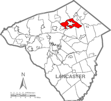
Clay Township is a township in north central Lancaster County, Pennsylvania, United States. The population was 6,887 at the 2020 census.

<span class="mw-page-title-main">Reamstown, Pennsylvania</span> Census-designated place in Pennsylvania, United States

Reamstown is an unincorporated community and census-designated place (CDP) in Lancaster County, Pennsylvania, United States. The population was 3,361 at the 2010 census.

<span class="mw-page-title-main">Rothsville, Pennsylvania</span> Census-designated place in Pennsylvania, United States

Rothsville is an unincorporated community and census-designated place (CDP) in Warwick Township, Lancaster County, Pennsylvania, United States. The population was 3,044 at the 2010 census. Lititz is the town for residents' mailing addresses.

<span class="mw-page-title-main">Strasburg Township, Pennsylvania</span> Township in Pennsylvania, United States

Strasburg Township is a township in south central Lancaster County, Pennsylvania, United States. The population was 4,467 at the 2020 census.

<span class="mw-page-title-main">West Hempfield Township, Pennsylvania</span> Township in Pennsylvania, United States

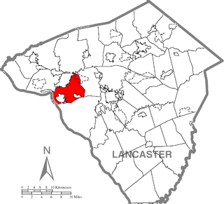
West Hempfield Township is a township in west central Lancaster County, Pennsylvania, United States. The population was 17,061 at the 2020 census.

<span class="mw-page-title-main">Quentin, Pennsylvania</span> Census-designated place in Pennsylvania, United States

Quentin is an unincorporated community and census-designated place (CDP) in Lebanon County, Pennsylvania, United States. It was named after Quentin Roosevelt, youngest son of President Theodore Roosevelt. The population was 594 at the 2010 census, up from 529 at the 2000 census.

<span class="mw-page-title-main">Shenango Township, Mercer County, Pennsylvania</span> Township in Pennsylvania, United States

Shenango Township is a township in Mercer County, Pennsylvania, United States. The population was 3,519 at the 2020 census, down from 3,929 in 2010.

<span class="mw-page-title-main">Juniata Township, Perry County, Pennsylvania</span> Township in Pennsylvania, United States

Juniata Township is a township in Perry County, Pennsylvania, United States. As of the 2020 census, the township population was 1,531.

<span class="mw-page-title-main">Brandonville, Pennsylvania</span> CDP in Pennsylvania, United States

Brandonville is a census-designated place (CDP) in East Union Township in Schuylkill County, Pennsylvania. The population was 180 at the 2020 census.

References

  1. "2016 U.S. Gazetteer Files". United States Census Bureau. Retrieved August 14, 2017.
  2. 1 2 3 4 Bureau, US Census. "City and Town Population Totals: 2020-2021". Census.gov. US Census Bureau. Retrieved July 9, 2022.
  3. "National Register Information System". National Register of Historic Places . National Park Service. July 9, 2010.
  4. "Census of Population and Housing". Census.gov. Retrieved June 4, 2016.
  5. "U.S. Census website". United States Census Bureau . Retrieved January 31, 2008.

40°10′00″N76°10′59″W / 40.16667°N 76.18306°W / 40.16667; -76.18306