Denver, Pennsylvania

Last updated

Denver, Pennsylvania
Downtown Denver, Pennsylvania (1), Nov. 2013.jpg
Downtown Denver at the intersection of Main and 4th streets
Lancaster County Pennsylvania Incorporated and Unincorporated areas Denver Highlighted.svg
Location of Denver in Lancaster County, Pennsylvania
USA Pennsylvania location map.svg
Red pog.svg
Denver
Location in Pennsylvania
Usa edcp location map.svg
Red pog.svg
Denver
Location in the United States
Coordinates: 40°14′02″N76°08′14″W / 40.23389°N 76.13722°W / 40.23389; -76.13722
CountryUnited States
StatePennsylvania
County Lancaster
Government
  MayorRodney L Redcay [1]
Area
[2]
  Total1.30 sq mi (3.36 km2)
  Land1.28 sq mi (3.31 km2)
  Water0.02 sq mi (0.05 km2)
Elevation
394 ft (120 m)
Population
 (2020) [3]
  Total3,792
  Density2,964.82/sq mi (1,144.48/km2)
Time zone UTC-5 (EST)
  Summer (DST) UTC-4 (EDT)
ZIP Code
17517
Area codes 717 and 223
FIPS code 42-18888
Website denverboro.net

Denver is a borough in Lancaster County, Pennsylvania, United States. The population was 3,794 at the 2020 census, [4] a decline from the figure of 3,861 tabulated in 2010.

Contents

History

Denver Keystone Marker Denver, Pennsylvania Keystone Marker, November 2013.jpg
Denver Keystone Marker

Denver was founded by in 1735, by Hans Bucher, a Swiss immigrant. It was originally known as Bucher's Thal, or "Bucher Valley", in reference to the adjacent Cocalico Creek. In the mid-18th century, a gristmill was built along the creek, and by 1772 six dwellings had been built. A blacksmith shop and a sawmill were operating by 1820. Early advantages for the settlement were fertile soils and the limestone formations that were mined for the manufacture of mortar, plaster and whitewash. In the 1830s, settler John Bucher became an advocate for using the lime as a fertilizer. Several limestone quarries were in turn operating by the 1850s. [5]

During the Civil War, the Reading and Columbia Railroad built a line through town, prompting a name change to "Union Station". With time, residents grew weary being referred to as a train station. After researching post offices in the country, Adam Brubaker found only one named Denver. On November 1, 1881, the town was officially renamed Denver. [6]

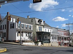
By the late 19th century, continued growth had some residents considering incorporating as a borough. The tipping point was a major fire at the Denver House, a tavern built behind the train station in 1868. Water from a local well and the nearby Cocalico Creek was insufficient to fight the fire, prompting tobacco merchant Aaron Shirk, physician W.D. Fink and businessman Ephraim Renninger to press for incorporation, so a municipal water system could be created. The trio filed an application for incorporation in April 1900, and by that December, Denver Borough had come into being. It originally encompassed 183 acres (74 ha), about a quarter its current size. [5]

With the turn of the century, the new borough purchased a reservoir site and constructed a water plant, which went online in 1902. By 1906, the one quarry still in operation today just outside Denver was opened in 1906 by Abram G. Kurtz. Around the time Denver was incorporated, cigar making was the dominant industry in the area, but mechanization eventually doomed the trade in hand-rolling cigars. New industries sprouted up, including the F&M Hat Company, founded in 1912 by brothers Samuel and Daniel Fichthorn along with their brother-in-law Ambrose Marburger. F&M Hat quickly grew into the town's largest employer, giving generations of residents jobs in its factory. By 1939 there were 835 employees working two shifts. [5]

In 1977, the Cocalico Eagles boys basketball team, under the direction of coach Ed McIlmoyle, defeated Mercer, 75–59, in the PIAA Class AA state championship game. [7]

Bucher's Mill Covered Bridge, south of Denver near Reamstown, was listed on the National Register of Historic Places in 1980. [8]

Geography

Denver is located in northeastern Lancaster County at 40°14′2″N76°8′14″W / 40.23389°N 76.13722°W / 40.23389; -76.13722 (40.233859, -76.137088). [9] It is bordered to the southeast by Reamstown and to the southwest by Stevens. Interstate 76, the Pennsylvania Turnpike, passes through the northern side of the borough, with the closest access 3 miles (5 km) to the east at Exit 286 (U.S. Route 222). Denver is 17 miles (27 km) northeast of Lancaster and 15 miles (24 km) southwest of Reading.

According to the United States Census Bureau, the borough has a total area of 1.3 square miles (3.4 km2), of which 0.02 square miles (0.05 km2), or 1.45%, are water. [10] Denver sits in a valley formed by Cocalico Creek to the west and Little Cocalico Creek to the east; the two creeks join at the southern border of the borough. Cocalico Creek is a tributary of the Conestoga River and part of the Susquehanna watershed.

Demographics

Historical population
CensusPop.Note
1910 933
1920 1,12520.6%
1930 1,2036.9%
1940 1,42818.7%
1950 1,65816.1%
1960 1,87513.1%
1970 2,24819.9%
1980 2,018−10.2%
1990 2,86141.8%
2000 3,33216.5%
2010 3,86115.9%
2020 3,794−1.7%
2021 (est.)3,770 [4] −0.6%
Sources: [11] [12] [13] [14] [3]

As of the census [12] of 2010, there were 15,391 people, 5,507 households, and 4,204 families living in the 17517 zip code. The population density was 11,839.2 people per square mile (4,571.1 people/km2). There were 5,705 housing units at an average density of 4,388.5 per square mile (1,694.4/km2). The racial makeup of the borough was 96.5% White, 1.2% Black or African American, 2.2% Asian, 0.03% Pacific Islander, 0.8% from other races, and 1.1% from two or more races. 2.28% of the population were Hispanic or Latino of any race.

There were 5,507 households, out of which 36.5% had children under the age of 18 living with them, 61.4% were married couples living together, 8.5% had a female householder with no husband present, and 25.4% were non-families. 21.1% of all households were made up of individuals, and 8.5% had someone living alone who was 65 years of age or older. The average household size was 2.63 and the average family size was 3.04.

In the borough the population was spread out, with 26.5% under the age of 18, 8.0% from 18 to 24, 24.1% from 25 to 44, 27.2% from 45 to 64, and 14.2% who were 65 years of age or older. The median age was 38.7 years. For every 100 females there were 98.2 males. For every 100 females age 18 and over, there were 98.1 males.

From the 2000 Census, The median income for a household in the borough was $49,085, and the median income for a family was $53,125. Males had a median income of $36,250 versus $23,715 for females. The per capita income for the borough was $19,706. About 4.5% of families and 5.2% of the population were below the poverty line, including 5.4% of those under age 18 and 3.3% of those age 65 or over.

Education

Denver Borough is served by the Cocalico School District.

Elementary

Middle

High

Related Research Articles

<span class="mw-page-title-main">Akron, Pennsylvania</span> Borough in Pennsylvania, United States

Akron is a borough in Lancaster County, Pennsylvania, United States. As of the 2020 census, it had a population of 4,169,

<span class="mw-page-title-main">Ephrata, Pennsylvania</span> Borough in Pennsylvania, United States

Ephrata is a borough in Lancaster County, Pennsylvania, United States. It is located 42 miles (68 km) east of Harrisburg and about 60 miles (97 km) west-northwest of Philadelphia and is named after Ephrath, the former name for current-day Bethlehem, which is now a Syriac Aramaic-, Hebrew- and Arabic-speaking community in Palestine. In its early history, Ephrata was a pleasure resort and an agricultural community.

<span class="mw-page-title-main">Strasburg, Pennsylvania</span> Borough in Pennsylvania, United States

Strasburg is a borough in Lancaster County, Pennsylvania, United States. It developed as a linear village stretching approximately 2 miles (3 km) along the Great Conestoga Road, later known as the Strasburg Road. The population was 3,117 at the 2020 census.

<span class="mw-page-title-main">Brickerville, Pennsylvania</span> Census-designated place in Pennsylvania, United States

Brickerville is an unincorporated community and census-designated place (CDP) in Elizabeth Township, Lancaster County, Pennsylvania, United States, with a ZIP code of 17543. The population was 1,309 at the 2010 census.

<span class="mw-page-title-main">East Cocalico Township, Lancaster County, Pennsylvania</span> Township in Pennsylvania, United States

East Cocalico Township is a township in northeastern Lancaster County, Pennsylvania, United States. At the 2020 census, the population was 10,808.

<span class="mw-page-title-main">East Donegal Township, Lancaster County, Pennsylvania</span> Township in Pennsylvania, United States

East Donegal Township is a township in northwestern Lancaster County, Pennsylvania, United States. At the 2020 census, the population was 8,690.

<span class="mw-page-title-main">South Heidelberg Township, Berks County, Pennsylvania</span> Township in Pennsylvania, United States

South Heidelberg Township is a township in Berks County, Pennsylvania, United States. The population was 7,271 at the 2010 census.

<span class="mw-page-title-main">Briar Creek, Pennsylvania</span> Borough in Pennsylvania, United States

Briar Creek is a borough in Columbia County, Pennsylvania, United States. It is part of Northeastern Pennsylvania. The population was 597 at the 2020 census. It is part of the Bloomsburg-Berwick micropolitan area.

<span class="mw-page-title-main">Ephrata Township, Lancaster County, Pennsylvania</span> Township in Pennsylvania, United States

Ephrata Township is a township in northeastern Lancaster County, Pennsylvania, United States. The population was 10,391 at the 2020 census.

<span class="mw-page-title-main">Quarryville, Pennsylvania</span> Borough in Pennsylvania, United States

Quarryville is a borough in Lancaster County, Pennsylvania, United States. The population was 2,852 at the 2020 census, an increase over the figure of 2,576 tabulated in 2010.

<span class="mw-page-title-main">Reamstown, Pennsylvania</span> Census-designated place in Pennsylvania, United States

Reamstown is an unincorporated community and census-designated place (CDP) in Lancaster County, Pennsylvania, United States. The population was 3,361 at the 2010 census.

<span class="mw-page-title-main">Rothsville, Pennsylvania</span> Census-designated place in Pennsylvania, United States

Rothsville is an unincorporated community and census-designated place (CDP) in Warwick Township, Lancaster County, Pennsylvania, United States. The population was 3,044 at the 2010 census. Lititz is the town for residents' mailing addresses.

<span class="mw-page-title-main">West Cocalico Township, Lancaster County, Pennsylvania</span> Township in Pennsylvania, United States

West Cocalico Township is a township that is located in northeastern Lancaster County, Pennsylvania, United States. The population was 7,491 at the time of the 2020 census.

<span class="mw-page-title-main">East Washington, Pennsylvania</span> Borough in Pennsylvania, United States

East Washington is a borough of Washington County, Pennsylvania, United States. The population was 1,858 at the time of the 2020 census.

<span class="mw-page-title-main">Hallam, Pennsylvania</span> Borough in Pennsylvania, United States

HallamHEL-əm is a borough in York County, Pennsylvania, United States. The population was 2,774 at the 2020 census.

<span class="mw-page-title-main">Adamstown, Pennsylvania</span> Place in Pennsylvania, United States

Adamstown is a borough that is located in Lancaster County and Berks County in the U.S. state of Pennsylvania.

<span class="mw-page-title-main">Cocalico School District</span>

The Cocalico School District is a small, suburban public school district located in Lancaster County, Pennsylvania in the United States. The school district covers the boroughs of Denver and Adamstown and East Cocalico Township and West Cocalico Township. Cocalico School District encompasses approximately 51 square miles (130 km2) square miles. According to 2008 local census data, it served a resident population of 21,095 people. Per 2011, US Census Bureau data, it serves a resident population of 21,115 people. The educational attainment levels for the Cocalico School District population were 80.9% high school graduates and 16% college graduates. In 2009, the district residents’ per capita income was $20,736, while the median family income was $54,850. In the Commonwealth, the median family income was $49,501 and the United States median family income was $49,445, in 2010. In Lancaster County, the median household income was $54,765.<ref>{{cite web |url=http://www.indexmundi.com/facts/united-states/quick-facts/pennsylvania/median-household-income#map |title=Pennsylvania Median household income, 2006-

Stevens is an unincorporated community and census-designated place (CDP) in Lancaster County, Pennsylvania, United States. As of the 2010 census, it had a population of 612. The Stevens post office has ZIP code 17578.

<span class="mw-page-title-main">Reinholds, Pennsylvania</span> Census-designated place in Pennsylvania, United States

Reinholds is an unincorporated community and census-designated place (CDP) in West Cocalico Township, Lancaster County, Pennsylvania, United States. As of the 2010 census the population was 1,803.

<span class="mw-page-title-main">Schoeneck, Pennsylvania</span> Census-designated place in Pennsylvania, United States

Schoeneck is an unincorporated community and census-designated place (CDP) that is located in West Cocalico Township, Lancaster County, Pennsylvania, United States. The name Schoeneck is a corruption of the Pennsylvania Dutch phrase, "Schoenes Eck," which translates to "pretty corner."

References

  1. "Mayor". Borough of Denver. Retrieved December 20, 2017.
  2. "ArcGIS REST Services Directory". United States Census Bureau. Retrieved October 12, 2022.
  3. 1 2 "Census Population API". United States Census Bureau. Retrieved October 12, 2022.
  4. 1 2 Bureau, US Census. "City and Town Population Totals: 2020-2021". Census.gov. US Census Bureau. Retrieved July 9, 2022.
  5. 1 2 3 Umble, Chad. "5 key moments in Denver's history". LancasterOnline. Retrieved May 3, 2020.
  6. "About Denver Borough". Denver Borough. Retrieved December 20, 2017.
  7. Thompson, Laura Eckert. "LNP Sports 365: A title for Cocalico". LancasterOnline. Retrieved May 3, 2020.
  8. "National Register Information System". National Register of Historic Places . National Park Service. July 9, 2010.
  9. "US Gazetteer files: 2010, 2000, and 1990". United States Census Bureau. February 12, 2011. Retrieved April 23, 2011.
  10. "2019 U.S. Gazetteer Files". United States Census Bureau. Retrieved July 28, 2020.
  11. "Census of Population and Housing". U.S. Census Bureau. Retrieved December 11, 2013.
  12. 1 2 "U.S. Census website". United States Census Bureau . Retrieved January 31, 2008.
  13. "Incorporated Places and Minor Civil Divisions Datasets: Subcounty Resident Population Estimates: April 1, 2010 to July 1, 2012". Population Estimates. U.S. Census Bureau. Archived from the original on June 11, 2013. Retrieved December 11, 2013.
  14. "Census of Population and Housing". Census.gov. Retrieved June 4, 2016.