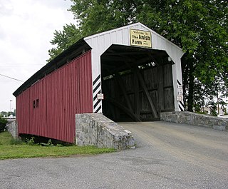
Intercourse is an unincorporated community and census-designated place (CDP) in Leacock Township, Lancaster County, in the U.S. state of Pennsylvania, 10 miles (16 km) east of Lancaster on Pennsylvania Route 340. As of the 2020 census, the population was 1,494, up from 1,274 at the previous census.

Paradise is an unincorporated community and census-designated place (CDP) in Lancaster County, Pennsylvania, United States, with a ZIP code of 17562. The population was 1,129 at the 2010 census.

Willow Street is an unincorporated community and census-designated place (CDP) in Lancaster County, Pennsylvania, United States. The population was 7,578 at the 2010 census. In the early part of the 20th century, the main thoroughfare in town was lined with willow trees on both sides for the length of the town, hence the community's name. As time passed and the town grew, the road was widened and sidewalks were installed, which required the trees be removed. Only a few of the original trees remain to this day.

Bird-in-Hand is an unincorporated community and census-designated place (CDP) in Lancaster County, Pennsylvania, United States, in East Lampeter Township. The "Bird in Hand" ZIP code extends east from the CDP into Leacock and Upper Leacock townships. The community has a large Amish and Mennonite population. As of the 2010 census, the population within the CDP was 402.

East Lampeter Township is a township in central Lancaster County, Pennsylvania, United States. At the 2020 census, the population was 17,834.

Gap is a census-designated place (CDP) and unincorporated community in Salisbury Township, Lancaster County, Pennsylvania, United States, with a ZIP code of 17527. The population was 1,931 at the 2010 census. U.S. Route 30 passes through the town, which is also the terminus for four Pennsylvania highways: 772, 741, 897, and the heavily used 41, which leads toward Wilmington, Delaware.
Hopeland is a small unincorporated hamlet and census-designated place (CDP) that is located in Lancaster County in the south of the U.S. state of Pennsylvania in the United States. The hamlet's ZIP code is 17533.

Kirkwood is an unincorporated farming town and census-designated place (CDP) in Colerain Township, Lancaster County, Pennsylvania, United States. It is part of the Lancaster Metro area, in Pennsylvania Dutch Country. The ZIP code is 17536. As of the 2010 census, the population was 396.
Stevens is an unincorporated community and census-designated place (CDP) in Lancaster County, Pennsylvania, United States. As of the 2010 census, it had a population of 612. The Stevens post office has ZIP code 17578.

Georgetown is an unincorporated community and census-designated place (CDP) in Bart Township, Lancaster County, Pennsylvania, United States. As of the 2010 census, the population was 1,022. Georgetown has a post office for P.O. boxes that is called Bart and has the ZIP code of 17503. Otherwise, the CDP is divided into three ZIP code areas for more distant communities.

Washington Boro is an unincorporated community and census-designated place (CDP) in Manor Township, Lancaster County, Pennsylvania, United States, along the Susquehanna River. The ZIP code is 17582. It is served by the Penn Manor School District and is the terminus of Pennsylvania Route 441 and Pennsylvania Route 999. As of the 2010 census, the population was 729.

Smoketown is an unincorporated village and census-designated place (CDP) in East Lampeter Township, Lancaster County, Pennsylvania, United States. Also known as Smoke Town, it is served by the Smoketown Airport. As of the 2010 census, it had a population of 357.

Reinholds is an unincorporated community and census-designated place (CDP) in West Cocalico Township, Lancaster County, Pennsylvania, United States. As of the 2010 census the population was 1,803.
Wakefield is an unincorporated community and census-designated place (CDP) within Fulton Township, Lancaster County, Pennsylvania, United States. As of the 2010 census, the population was 609. It is the largest community within the "Peach Bottom" ZIP code, with the area post office on Pennsylvania Route 272, just north of town.

Refton is an unincorporated community and census-designated place (CDP) in Strasburg Township, Lancaster County, Pennsylvania, United States, with a ZIP code of 17560. The community is located along U.S. Route 222. As of the 2010 census, the population was 298.

Churchtown is an unincorporated community and census-designated place (CDP) in Caernarvon Township, Lancaster County, Pennsylvania, United States, along Pennsylvania Route 23. The population was 470 as of the 2010 census.

Lampeter is an unincorporated community and census-designated place (CDP) in West Lampeter Township, Lancaster County, Pennsylvania, United States. As of the 2010 census, it had a population of 1,669. It is a suburb of Lancaster and has a ZIP code of 17537. The community was named after Lampeter, in Wales.

Slatedale is an unincorporated community and census-designated place (CDP) in Washington Township in Lehigh County, Pennsylvania. As of the 2010 census, it had a population of 455. It is part of the Lehigh Valley, which had a population of 861,899 and was the 68th-most populous metropolitan area in the U.S. as of the 2020 census.

Soudersburg is an unincorporated community and census-designated place (CDP) in East Lampeter and Leacock townships in Lancaster County, Pennsylvania, United States. As of the 2010 census, the population was 540.
Witmer is an unincorporated community and census-designated place (CDP) in East Lampeter Township, Lancaster County, Pennsylvania, United States. As of the 2010 census, the population was 492.


