Manor Township, Lancaster County, Pennsylvania

Last updated

Manor Township,
Lancaster County, Pennsylvania
Manor Township Downfall.jpg
Mann's Creek
Manor Township, Lancaster County Highlighted.png
Map of Lancaster County highlighting Manor Township
Country United States
State Pennsylvania
County Lancaster
Settled1719
Incorporated1730
Government
  TypeBoard of Supervisors
Area
[1]
  Total48.62 sq mi (125.92 km2)
  Land38.33 sq mi (99.28 km2)
  Water10.28 sq mi (26.63 km2)
Population
 (2020) [2]
  Total21,920 Increase2.svg
  Estimate 
(2021) [2]
21,954
  Density541.47/sq mi (209.06/km2)
Time zone UTC-5 (Eastern (EST))
  Summer (DST) UTC-4 (EDT)
Area code 717
FIPS code 42-071-46992
Website www.manortwp.org

Manor Township is a second-class township in west-central Lancaster County, Pennsylvania, United States. As of the 2020 census, it had a population of 21,920. [2]

Contents

History to 1763

Manor Township takes its name from the Manor of Conestoga, which was originally surveyed and reserved for William Penn in 1719, although there is evidence that William Penn visited this area prior to 1690. At this time, the area was Susquehannock territory, and the Susquehannock tribe themselves were the largest tribe in the Susquehanna Valley and had their center of the community within the Turkey Hill part of this territory. The Quaker government thus had surveyors lay off a large area bounded by the Little Conestoga Creek near what is now Millersville to the Susquehanna River and the Conestoga Creek.

When the land was ceded by William Penn to their ancestors in the 1690s, the Susquehannock tribe had lived on the land for quite some time. Their ancestors were Conestoga Native Americans, many of whom were Christian and had lived peacefully with their European neighbors for decades by bartering handicrafts, hunting, and receiving subsistence food given them by the Pennsylvania government. The area was called the Manor of Conestoga and may have been (as some historians speculate that it was) set aside by William Penn as a domain in which the Susquehannock tribe could live and hunt. The Manor contained 16,000 acres east of the Susquehanna River, thus being mostly well-watered flat land that contained rich and fertile soil.

Until the French and Indian War, however, the frontier of Pennsylvania remained largely unsettled. In the aftermath of the war, a new wave of Scots-Irish immigrants who are now known locally as "The Paxton Boys" encroached on the Penn-ceded land in the back country, often doing so in blatant violation of previously-signed treaties. Reverend John Elder, who was the parson at Paxtang, became a leader of these settlers, was known as the "Fighting Parson", and kept his rifle in the pulpit while he delivered his sermons. Elder then helped organize the settlers into a mounted militia and was named Captain of the group, whom called themselves the "Pextony boys" and claimed that the Natives often raided their homes and killed men, women and children.

Although there had been neither Susquehannock nor Conestoga attacks in the area, the Pextony Boys claimed that the Conestoga secretly provided aid and intelligence to their enemies. At daybreak on December 14, 1763, the vigilante group of the Scots-Irish frontiersmen attacked Conestoga homes at Conestoga Town (near present-day Millersville) and scalped and otherwise mutilated the males, raped and murdered the women and children, and burned their cabins, massacring all but 16 of the Natives. The colonial government then held an inquest, and the new governor, John Penn, offered a reward for capture of the Pextony Boys. Penn placed the remaining sixteen Conestoga in protective custody in Lancaster, though the Pextony Boys broke in on December 27, 1763, and murdered as well as dismembered six adults and eight children. The government of Pennsylvania offered a new reward after this second attack, this time $600, for the capture of anyone involved, but the attackers were never identified.

Manor Township therefore still memorializes the murdered Natives by using as its official logo a Native American Chief in full headdress with the date 1763 below it.

1763 to 1863

For the next 100 years, the township was subdivided as the large plantations in were cut into smaller tracts to accommodate growing families. In 1846, the 83rd year, the iron industry came to the Township in 1846 when the Iron Works factory was built in the village of Safe Harbor. The Iron Works factory provided jobs for heads of the households as well as the T-shaped rail that was the principal product of the mill.

When the Civil War came close to Manor Township in 1863, the 100th year, Governor Curtin called every able-bodied man to enroll for the defense of the entire State of Pennsylvania. Citizens of Manor Township and Millersville assembled at the headquarters at Safe Harbor, although the invasion threat to Lancaster County ended as the Columbia-Wrightsville Bridge was burned and Lee's army was defeated at the Battle of Gettysburg.

1863 and thereafter

By 1880, the population of Manor Township was approximately 4,000 people. From the late 1800s through the mid 1900s, the township was known for producing fine tobacco crops, and its farmers produced more tobacco than any township in Lancaster County. Churches and schools were built as the area continued to grow, and the railroad along the western boundary of the township enabled the development of more factories, including a woolen factory near Safe Harbor, match factory in Safe Harbor, and an implement factory near Millersville. In April 1930, construction began on the dam for the Safe Harbor Water Power Corporation and was completed twenty months later.

In 1973, Washington Boro officially merged into Manor Township, and most of Manor Township has remained rural and agricultural in use. The land is considered by soil scientists to be as fertile as any in the United States, and the vast majority of development has occurred in the north eastern section of the Township. [3]

Geography

According to the United States Census Bureau, the township has a total area of 48.6 square miles (125.9 km2), of which 38.5 square miles (99.8 km2) are land and 10.1 square miles (26.1 km2), or 20.70%, are water. Unincorporated communities and neighborhoods in the township include Manor Ridge, West Lancaster, West Ridge, Windom, Washington Boro, Central Manor, Letort, Indian Town, Creswell, Highville, Pittsburg Valley, and part of Donerville.

Demographics

Historical population
CensusPop.Note
2000 16,498
2010 19,61218.9%
2020 21,92011.8%
2021 (est.)21,954 [2] 0.2%
U.S. Decennial Census [4]

As of the census [5] of 2000, there were 16,498 people, 6,464 households, and 4,699 families residing in the township. The population density was 427.9 inhabitants per square mile (165.2/km2). There were 6,710 housing units at an average density of 174.0 per square mile (67.2/km2). The racial makeup of the township was 95.64% White, 1.35% African American, 0.10% Native American, 1.26% Asian, 0.01% Pacific Islander, 0.78% from other races, and 0.86% from two or more races. Hispanic or Latino of any race were 2.28% of the population.

There were 6,464 households, out of which 31.4% had children under the age of 18 living with them, 62.3% were married couples living together, 7.5% had a female householder with no husband present, and 27.3% were non-families. 22.5% of all households were made up of individuals, and 8.9% had someone living alone who was 65 years of age or older. The average household size was 2.53 and the average family size was 2.99.

In the township, the population was spread out, with 24.0% under the age of 18, 7.3% from 18 to 24, 28.6% from 25 to 44, 24.6% from 45 to 64, and 15.4% whom were 65 years of age or older. The median age was 39 years. For every 100 females, there were 95.9 males. For every 100 females age 18 and over, there were 91.2 males.

The median income for a household in the township was $47,806, and the median income for a family was $54,958. Males had a median income of $37,932 versus $27,398 for females. The per capita income for the township was $22,243. About 2.4% of families and 3.8% of the population were below the poverty line, including 3.4% of those under age 18 and 6.2% of those age 65 or over.

The population increased to 19,612 by the time of the 2010 census., [6] and the town continues to maintain its present (160-year-old) form (as of 2019).

Related Research Articles

<span class="mw-page-title-main">Lancaster County, Pennsylvania</span> County in Pennsylvania, United States

Lancaster County, sometimes nicknamed the Garden Spot of America or Pennsylvania Dutch Country, is a county in the Commonwealth of Pennsylvania. As of the 2020 census, the population was 552,984, making it Pennsylvania's sixth-most populous county. Its county seat is also Lancaster. Lancaster County comprises the Lancaster metropolitan statistical area. The county is part of the South Central region of the state.

<span class="mw-page-title-main">Millersville, Pennsylvania</span> Borough in Pennsylvania, United States

Millersville is a borough in Lancaster County, Pennsylvania, United States. At the 2020 census, the population was 7,629 and in 2021 it was estimated at 7,593. Millersville is home to Millersville University of Pennsylvania.

<span class="mw-page-title-main">Willow Street, Pennsylvania</span> Census-designated place in Pennsylvania, United States

Willow Street is an unincorporated community and census-designated place (CDP) in Lancaster County, Pennsylvania, United States. The population was 7,578 at the 2010 census. In the early part of the 20th century, the main thoroughfare in town was lined with willow trees on both sides for the length of the town, hence the community's name. As time passed and the town grew, the road was widened and sidewalks were installed, which required the trees be removed. Only a few of the original trees remain to this day.

<span class="mw-page-title-main">Brickerville, Pennsylvania</span> Census-designated place in Pennsylvania, United States

Brickerville is an unincorporated community and census-designated place (CDP) in Elizabeth Township, Lancaster County, Pennsylvania, United States, with a ZIP code of 17543. The population was 1,309 at the 2010 census.

<span class="mw-page-title-main">Conestoga Township, Pennsylvania</span> Township in Pennsylvania, United States

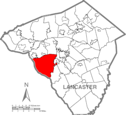
Conestoga Township is a township in west central Lancaster County, Pennsylvania. At the 2020 census, the population was 3,922.

<span class="mw-page-title-main">Gap, Pennsylvania</span> Census-designated place in Pennsylvania, United States

Gap is a census-designated place (CDP) and unincorporated community in Salisbury Township, Lancaster County, Pennsylvania, United States, with a ZIP code of 17527. The population was 1,931 at the 2010 census. U.S. Route 30 passes through the town, which is also the terminus for four Pennsylvania highways: 772, 741, 897, and the heavily used 41, which leads toward Wilmington, Delaware.

<span class="mw-page-title-main">Spring Township, Berks County, Pennsylvania</span> Township in Pennsylvania, United States

Spring Township is a township in Berks County, Pennsylvania, United States. The population was 27,119 at the 2010 census, making it the second most populous municipality in Berks County after Reading.

<span class="mw-page-title-main">Haines Township, Centre County, Pennsylvania</span> Township in Pennsylvania, United States

Haines Township is a township in Centre County, Pennsylvania, United States. It is part of the State College, Pennsylvania Metropolitan Statistical Area. The population was 1,663 at the 2020 census.

<span class="mw-page-title-main">Lower Swatara Township, Pennsylvania</span> Township in Pennsylvania, United States

Lower Swatara Township is a township in Dauphin County, Pennsylvania, United States. The population was 9,557 at the 2020 census. Harrisburg International Airport and Penn State Harrisburg are located within the township. It shares a ZIP Code with the nearby borough of Middletown, and all locations in the township have Middletown addresses.

<span class="mw-page-title-main">Paxtang, Pennsylvania</span> Borough in Pennsylvania, United States

Paxtang is a borough in Dauphin County, Pennsylvania, United States. As of the 2020 census it had a population of 1,640. The borough is a suburb of Harrisburg and is one of the earliest colonial settlements in South Central Pennsylvania.

<span class="mw-page-title-main">Lancaster Township, Lancaster County, Pennsylvania</span> Township in Pennsylvania, United States

Lancaster Township is a civil township of Lancaster County, Pennsylvania, United States. It is in the central area of the county, and it immediately surrounds Lancaster City. As of the 2020 census, the township population was 18,591.

<span class="mw-page-title-main">Mountville, Pennsylvania</span> Borough in Pennsylvania, United States

Mountville is a borough in Lancaster County, Pennsylvania, United States. The population was 3,022 at the 2020 census, an increase over the figure of 2,802 tabulated in 2010. The original Charles Chips potato chip factory was located here.

<span class="mw-page-title-main">Pequea Township, Pennsylvania</span> Township in Pennsylvania, United States

Pequea Township is a township that is located in central Lancaster County, Pennsylvania, United States. The population was 5,493 at the time of the 2020 census.

<span class="mw-page-title-main">Duryea, Pennsylvania</span> Borough in Pennsylvania, United States

Duryea is a borough in the Greater Pittston area of Luzerne County, Pennsylvania, United States, 9 miles (14 km) south of Scranton. The Susquehanna River marks Duryea's western boundary and the Lackawanna River flows through Duryea. It was incorporated as a borough in 1901, and had a notable switching rail yard, the Duryea yard, connecting the central Wyoming Valley to destinations in lower New York and down-state Pennsylvania. Coal mining and silk manufacturing were the chief industries in Duryea's early years. The population was 5,032 at the 2020 census.

<span class="mw-page-title-main">Susquehannock</span> Indigenous people of the Eastern Woodlands

The Susquehannock, also known as the Conestoga, Minquas, and Andaste, were an Iroquoian people who lived in the lower Susquehanna River watershed in what is now Pennsylvania. Their name means “people of the muddy river.”

<span class="mw-page-title-main">Paxton Boys</span> Vigilante group in colonial Pennsylvania

The Paxton Boys, also known as the Paxtang Boys or the Paxton Rangers, were a mob of settlers that murdered 20 unarmed Conestoga in Lancaster County, Pennsylvania, in December 1763. This group of vigilantes from Lancaster and Cumberland counties formed in 1763 to defend themselves from Indigenous attacks during Pontiac's War. The Paxton Boys justified their actions by claiming that the Conestoga were colluding with the Lenape and Shawnee who were attacking Pennsylvania's frontier settlements. According to historian Kevin Kenny, the Paxton Boys were Pennsylvania's most aggressive colonists.

<span class="mw-page-title-main">Conestoga River</span> River in Pennsylvania, United States

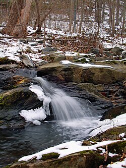
The Conestoga River, also referred to as Conestoga Creek, is a 61.6-mile-long (99.1 km) tributary of the Susquehanna River flowing through the center of Lancaster County, Pennsylvania, United States.

<span class="mw-page-title-main">Conestoga, Pennsylvania</span> Census-designated place in Pennsylvania, United States

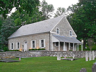
Conestoga is an unincorporated community and census-designated place (CDP) in Conestoga Township, Lancaster County, Pennsylvania, United States. At the 2020 census, the population was 1,163. The Conestoga post office serves ZIP code 17516.

<span class="mw-page-title-main">Penn Manor School District</span> School district in Pennsylvania

The Penn Manor School District is a large, rural/suburban, public school district located in Lancaster County, Pennsylvania. The Penn Manor School District encompasses approximately 110 square miles. Penn Manor School District serves residents of: Manor Township, Conestoga Township, Millersville Borough, Martic Township and Pequea Township. According to 2000 federal census data, it serves a resident population of 37,942. By 2010, the district's population was 41,376 people. In 2009, Penn Manor Sas $20,529 and the median family income was $55,708. The educational attainment levels for the Penn Manor School District population were 88.7% high school graduates and 25% college graduates.

<span class="mw-page-title-main">Reinholds, Pennsylvania</span> Census-designated place in Pennsylvania, United States

Reinholds is an unincorporated community and census-designated place (CDP) in West Cocalico Township, Lancaster County, Pennsylvania, United States. As of the 2010 census the population was 1,803.

References

  1. "2016 U.S. Gazetteer Files". United States Census Bureau. Retrieved August 14, 2017.
  2. 1 2 3 4 Bureau, US Census. "City and Town Population Totals: 2020-2021". Census.gov. US Census Bureau. Retrieved July 9, 2022.
  3. "Manor Township -". www.manortwp.org.
  4. "Census of Population and Housing". Census.gov. Retrieved June 4, 2016.
  5. "U.S. Census website". United States Census Bureau . Retrieved January 31, 2008.
  6. Bureau, U.S. Census. "U.S. Census website". United States Census Bureau . Retrieved February 26, 2017.

39°58′00″N76°24′59″W / 39.96667°N 76.41639°W / 39.96667; -76.41639