California Historical Landmarks in Santa Barbara County

Last updated

List table of the properties and districts — listed on the California Historical Landmarks — within Santa Barbara County , California.

Contents

  • Note: Click the "Map of all coordinates" link to the right to view a Google map of all properties and districts with latitude and longitude coordinates in the table below.

Listings

Image [1] Landmark nameLocationCity or townSummary
Burton Mound SB BurtonMoundLandmarkPlaque 20170915.jpg
Burton Mound
306 Burton Mound 129 W. Mason St. at Burton Circle
34°24′40″N119°41′32″W / 34.410983°N 119.6921°W / 34.410983; -119.6921 (Burton Mound)
Santa Barbara A second plaque is at 1000 Carpinteria Ave.
Carpinteria and Indian Village of Mishopshnow Museumsign.JPG
Carpinteria and Indian Village of Mishopshnow
535 Carpinteria and Indian Village of Mishopshnow Carpinteria Valley Museum of History, 950 Maple Ave
34°23′33″N119°30′39″W / 34.39255°N 119.510917°W / 34.39255; -119.510917 (Carpinteria and Indian Village of Mishopshnow)
Carpinteria
Carrillo Adobe Hill-Carrillo Adobe.jpg
Carrillo Adobe
721 Carrillo Adobe 11 E Carrillo St.
34°25′19″N119°42′06″W / 34.421944°N 119.701736°W / 34.421944; -119.701736 (Carrillo Adobe)
Santa Barbara Also on the NRHP list as NPS-86000778
Casa de la Guerra Casa de la Guerra right side.jpg
Casa de la Guerra
307 Casa de la Guerra 808-818 State St., 813-819 Anacapa St., and 9-25 E. de la Guerra St.
34°25′13″N119°41′57″W / 34.420278°N 119.699167°W / 34.420278; -119.699167 (Casa de la Guerra)
Santa Barbara Also on the NRHP list as NPS-77000346
Chapel of San Ramon San Ramon 03.jpg
Chapel of San Ramon
877 Chapel of San Ramon Tepusquet and Foxen Canyon Rds.
34°50′52″N120°14′27″W / 34.847833°N 120.240917°W / 34.847833; -120.240917 (Chapel of San Ramon)
Santa Maria
Covarrubias Adobe USA-Santa Barbara-Historic and Covarrubias Adobes-1.jpg
Covarrubias Adobe
308 Covarrubias Adobe 715 N Santa Barbara St.
34°25′16″N119°41′48″W / 34.421045°N 119.696726°W / 34.421045; -119.696726 (Covarrubias Adobe)
Santa Barbara
Gaviota Pass Aerial-GavPassTunnel.jpg
Gaviota Pass
248 Gaviota Pass U.S. Route 101
34°29′07″N120°13′43″W / 34.485333°N 120.228533°W / 34.485333; -120.228533 (Gaviota Pass)
Goleta
Hastings Adobe Trussell-Winchester Adobe.png
Hastings Adobe
559 Hastings Adobe 412 W Montecito St.
34°24′37″N119°41′52″W / 34.4104083333333°N 119.6979°W / 34.4104083333333; -119.6979 (Hastings Adobe)
Santa Barbara Also called the Trussell-Winchester Adobe. [2]
Mission La Purisima Concepcion La Purisima Mission.jpg
Mission La Purisima Concepción
340 Mission La Purisima Concepción La Purisima Mission State Historic Park
34°40′14″N120°25′15″W / 34.670683°N 120.420883°W / 34.670683; -120.420883 (Mission La Purisima Concepción)
Lompoc Also on the NRHP list as NPS-70000147
Lobero Theatre Lobero.jpg
Lobero Theatre
361 Lobero Theatre 33 E Canon Perdido St.
34°25′18″N119°42′00″W / 34.4216°N 119.6999°W / 34.4216; -119.6999 (Lobero Theatre)
Santa Barbara
Mission Santa Barbara Mission Santa Barbara01.jpg
Mission Santa Barbara
309 Mission Santa Barbara 2201 Laguna St.
34°26′18″N119°42′50″W / 34.438333°N 119.713917°W / 34.438333; -119.713917 (Mission Santa Barbara)
Santa Barbara Also on the NRHP list as NPS-66000237
Mission Santa Ines Santa Ines circa 1900 Keystone-Mast.jpg
Mission Santa Inés
305 Mission Santa Inés 1760 Mission Dr.
34°35′40″N120°08′12″W / 34.594489°N 120.136603°W / 34.594489; -120.136603 (Mission Santa Inés)
Solvang
Presidio of Santa Barbara SB Presidio.jpg
Presidio of Santa Barbara
636 Presidio of Santa Barbara El Presidio de Santa Barbara State Historic Park
34°25′21″N119°41′50″W / 34.422567°N 119.6971°W / 34.422567; -119.6971 (Presidio of Santa Barbara)
Santa Barbara Also on the NRHP list as NPS-73000455
Santa Barbara County Courthouse Santa Barbara County Courthouse.jpg
Santa Barbara County Courthouse
1037 Santa Barbara County Courthouse 1100 Anacapa St.
34°25′28″N119°42′09″W / 34.42435°N 119.702461°W / 34.42435; -119.702461 (Santa Barbara County Courthouse)
Santa Barbara Also on the NRHP list as NPS-81000177
Site of original mission and remaining ruins of La Purisima Mission Ruins of Mission La Purisima Concepcion, ca.1885-1904 (CHS-1803).jpg
Site of original mission and remaining ruins of La Purisima Mission
928 Site of original mission and remaining ruins of La Purisima Mission 541 South F Street
34°37′53″N120°27′19″W / 34.631504°N 120.45541°W / 34.631504; -120.45541 (Site of original mission and remaining ruins of La Purisima Mission)
Lompoc Ruin remains of first La Purisima Mission [3]
Well, Hill 4 OrcuttField1911.jpg
Well, Hill 4
582 Well, Hill 4 Unocal Corporation, Mission Hills District
34°42′58″N120°24′33″W / 34.716075°N 120.409202777778°W / 34.716075; -120.409202777778 (Well, Hill 4)
Lompoc Plaque is behind gated facility. [4]

See also

Related Research Articles

<span class="mw-page-title-main">National Register of Historic Places listings in San Diego County, California</span>

This is a list of the National Register of Historic Places listings in San Diego County, California.

<span class="mw-page-title-main">National Register of Historic Places listings in Ventura County, California</span>

This is a list of the National Register of Historic Places listings in Ventura County, California.

<span class="mw-page-title-main">National Register of Historic Places listings in Humboldt County, California</span>

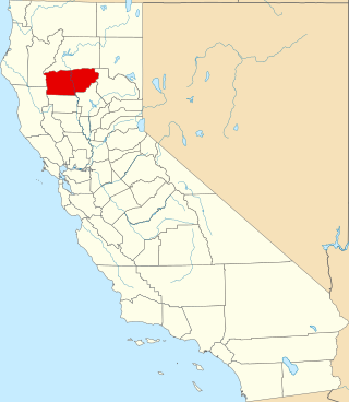
This is a list of the National Register of Historic Places listings in Humboldt County, California.

<span class="mw-page-title-main">National Register of Historic Places listings in Santa Clara County, California</span>

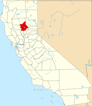
This is intended to be a complete list of the properties and districts on the National Register of Historic Places in Santa Clara County, California, United States. Latitude and longitude coordinates are provided for many National Register properties and districts; these locations may be seen together in an online map.

<span class="mw-page-title-main">National Register of Historic Places listings in Sonoma County, California</span>

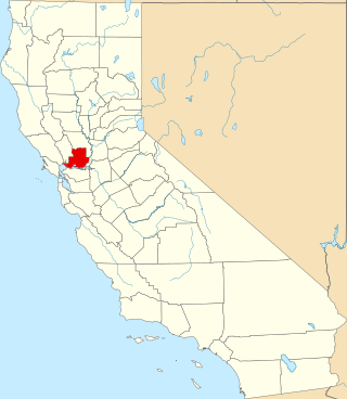
This is a list of the National Register of Historic Places listings in Sonoma County, California.

<span class="mw-page-title-main">National Register of Historic Places listings in Riverside County, California</span>

This is a list of the National Register of Historic Places listings in Riverside County, California.

<span class="mw-page-title-main">National Register of Historic Places listings in Santa Cruz County, California</span>

This is a list of the National Register of Historic Places listings in Santa Cruz County, California.

<span class="mw-page-title-main">National Register of Historic Places listings in Santa Barbara County, California</span>

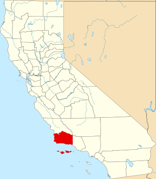
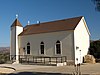
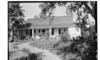
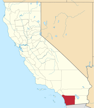
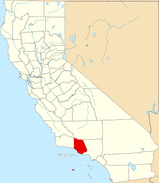
This is a list of the National Register of Historic Places listings in Santa Barbara County, California.

<span class="mw-page-title-main">National Register of Historic Places listings in Butte County, California</span>

This is a list of the National Register of Historic Places listings in Butte County, California.

<span class="mw-page-title-main">National Register of Historic Places listings in Solano County, California</span>

This is a list of the National Register of Historic Places listings in Solano County, California.

<span class="mw-page-title-main">National Register of Historic Places listings in Mono County, California</span>

This is a list of the National Register of Historic Places listings in Mono County, California.

<span class="mw-page-title-main">National Register of Historic Places listings in Merced County, California</span>

This is a list of the National Register of Historic Places listings in Merced County, California.

<span class="mw-page-title-main">National Register of Historic Places listings in Tehama County, California</span>

This is a list of the National Register of Historic Places listings in Tehama County, California.

List table of the properties and districts — listed on the California Historical Landmarks in Los Angeles County, Southern California.

List table of the properties and districts listed on the California Historical Landmarks within Riverside County, southern California.

This list includes properties and districts listed on the California Historical Landmark listing in Sacramento County, California. Click the "Map of all coordinates" link to the right to view a Google map of all properties and districts with latitude and longitude coordinates in the table below.

List table of the properties and districts — listed on the California Historical Landmarks — within Santa Cruz County, California.

This is a list of the properties and districts — listed as California Historical Landmarks — within Sonoma County, California.

List table of the properties and districts — listed on the California Historical Landmarks — within Santa Clara County, California.

The City of Santa Barbara Historic Landmarks consist of buildings and sites designated by the City of Santa Barbara, California, as historic landmarks. The city also maintains a list of Structures of Merit, a Historic Resources Inventory, and a list of designated and potential Historic Districts.

References

  1. "California Historical Landmarks By County". Ohp.parks.ca.gov. Retrieved 2019-04-03.
  2. californiahistoricallandmarks.com Hastings Adobe
  3. californiahistoricallandmarks.com 928, Ruin remains
  4. californiahistoricallandmarks.com Well, Hill 4