Coombe Dingle, Bristol

Last updated

Coombe Dingle
The Dingle, Combe Dingle - geograph.org.uk - 117932.jpg
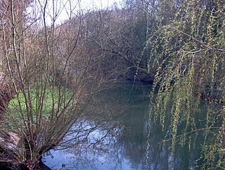
The Dingle, Coombe Dingle
Bristol UK location map.svg
Red pog.svg
Coombe Dingle
Location within Bristol
OS grid reference ST552775
Unitary authority
Ceremonial county
Region
Country England
Sovereign state United Kingdom
Post town BRISTOL
Postcode district BS
Dialling code 0117
Police Avon and Somerset
Fire Avon
Ambulance South Western
UK Parliament
List of places
UK
England
Bristol
51°29′43″N2°38′46″W / 51.4952°N 2.6460°W / 51.4952; -2.6460


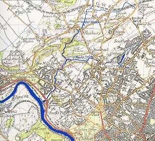
Coombe Dingle is a suburb of Bristol, England, centred near where the Hazel Brook tributary of the River Trym emerges from a limestone gorge bisecting the Blaise Castle Estate to join the main course of the Trym. Historically this area formed part of the parish of Westbury on Trym, Gloucestershire, and it is now part of Kingsweston ward of the city of Bristol. South of Coombe Dingle is Sea Mills; to the north is Kings Weston Hill; to the west are Kings Weston House and Shirehampton Park; and to the east, Henbury Golf Club and Westbury on Trym proper.

The inhabited place appears simply as Combe, Coomb or Coombe, meaning 'short bowl-shaped valley', in documents from the 13th century onwards and on early maps. The name applied to Coombe Farm and Coombe House on the eastern side of the confluence of the Hazel Brook and the Trym, not where the modern suburb lies. This area later became noted for its cherry orchards, commemorated in a modern house-name, and a nursery. Strictly speaking, Coombe Dingle was the wooded narrow valley through which the Trym passes south-west of the farm and house to flow southwards through Sea Mills to the River Avon. The name of the narrow valley was borrowed for the new development consisting mostly of private housing built to the west of the Trym in the 1920s and 1930s on an area called Boulton's (or Bowden's) Fields. It was and remains a desirable area to live. Near the western edge is Haig Close, a small development of houses originally built for ex-servicemen in 1929 on land donated from the Kingsweston Estate by Philip Napier Miles, though this is generally said to be in Sea Mills.

Coombe Dingle was once a popular destination for outings from Bristol, and there was a well-known tea-room and tea garden in the wooded Dingle itself, now a private house (just West of Grove Road on The Dingle). It was there by 1888 and used to be known as Appletree Cottage. [1] The original winding road passing it, called The Dingle, has been bypassed by the modern A4162, which is carried across the river on its own bridge with a classical-style balustrade. Sylvan Way and the bridge were built in about 1920. [2] The bridge is made of in situ cast concrete. It is quite an early example showing the arch design of brick and stone bridges, but built of a material for which an arch is unnecessary. [3] In the Dingle itself, the river drove a flour mill called Coombe Mill.

Below Coombe House, just above the confluence of the Trym and Hazel Brook, was a sluice where the footbridge now is. This diverted the water through a mill stream to Hazel Brook. Another sluice there diverted the water into a millstream which ran approximately below where the main path now runs down to the site of the mill. This clever arrangement meant that when the flow in Hazel Brook was low the miller could use the water of the River Trym as well as that of Hazel Brook. [4]

Coombe House which stood to the South of the confluence of Hazel Brook and the Trym, backing on to Canford Lane, was the home of John Graves Livingston (born J.G. Thompson) who was a long time director and chairman of the Ffestiniog Railway Company. For more information see: https://www.festipedia.org.uk/wiki/John_Graves_Livingston

There is a parade of shops on Westbury Lane. There used to be, close to the road bridge and near the northern end of Coombe Lane, a "tin" (i.e. corrugated iron) Methodist chapel. [5] It was a small building with plain Gothic-style windows dating from the 1890s, demolished in the mid-1990s and replaced by a house. There are no other places of worship in Coombe Dingle.

Coombe Lane is the home of Bristol University sports complex, which is commonly referred to as Coombe Dingle, though it is really in Stoke Bishop.

Related Research Articles

<span class="mw-page-title-main">River Frome, Bristol</span> River in south west England

The Frome, historically the Froom, is a river that rises in Dodington Park, South Gloucestershire and flows southwesterly through Bristol to join the river Avon. It is approximately 20 miles (32 km) long, and the mean flow at Frenchay is 60 cubic feet per second (1.7 m3/s). The name Frome is shared with several other rivers in South West England and means 'fair, fine, brisk'. The river is known locally in east Bristol as the Danny.

<span class="mw-page-title-main">Henbury</span> Human settlement in England

Henbury is a suburb of Bristol, England, approximately 5 miles (8.0 km) north west of the city centre. It was formerly a village in Gloucestershire and is now bordered by Westbury-on-Trym to the south; Brentry to the east and the Blaise Castle Estate, Blaise Hamlet and Lawrence Weston to the west. To the north lie the South Gloucestershire village of Hallen and the entertainment/retail park Cribbs Causeway.

<span class="mw-page-title-main">Blaise Castle Estate</span> Folly built in 1766 near Henbury in Bristol, England

Blaise Castle is a folly built in 1766 near Henbury in Bristol, England. The castle sits within the Blaise Castle Estate, which also includes Blaise Castle House, a Grade II* listed 18th-century mansion house. The folly castle is also Grade II* listed and ancillary buildings including the orangery and dairy also have listings. Along with Blaise Hamlet, a group of nine small cottages around a green built in 1811 for retired employees, and various subsidiary buildings, the parkland is listed Grade II* on the Register of Historic Parks and Gardens of special historic interest in England.

<span class="mw-page-title-main">Southmead</span> Human settlement in England

Southmead is a northern suburb and council ward of Bristol, in the south west of England, bordered by Filton in South Gloucestershire and Monks Park, Horfield, Henleaze and Westbury on Trym.

<span class="mw-page-title-main">Shirehampton</span> Human settlement in England

Shirehampton is a district of Bristol in England, near Avonmouth, at the northwestern edge of the city.

<span class="mw-page-title-main">Westbury-on-Trym</span> Human settlement in England

Westbury on Trym is a suburb and council ward in the north of the City of Bristol, near the suburbs of Stoke Bishop, Westbury Park, Henleaze, Southmead and Henbury, in the southwest of England.

<span class="mw-page-title-main">River Trym</span> Short river in the United Kingdom

The River Trym is a short river, some 4.5 miles (7.2 km) in length, which rises in Filton, South Gloucestershire, England. The upper reaches are culverted, some underground, through mostly urban landscapes, but once it emerges into the open it flows through a nature reserve and city parks before joining the tidal River Avon at Sea Mills. 18th-century water mills near the mouth gave the area its name.

<span class="mw-page-title-main">Lawrence Weston, Bristol</span> Human settlement in England

Lawrence Weston is a post-war housing estate in northwest Bristol, England, between Henbury and Shirehampton.

Sea Mills is a suburb of the English port city of Bristol. It is situated 3.5 miles (6 km) north-west of the city centre, towards the seaward end of the Avon Gorge, lying between the former villages of Shirehampton to the west and Westbury-on-Trym and Stoke Bishop to the east, at the mouth of the River Trym where it joins the River Avon. Sea Mills previously was part of the city ward of Kingsweston. Following a Local Government Boundary Commission review in 2015 ward boundaries were redrawn and Sea Mills is now split between the Stoke Bishop ward and the Avonmouth and Lawrence Weston ward.

The city of Bristol, England, is divided into many areas, which often overlap or have non-fixed borders. These include Parliamentary constituencies, council wards and unofficial neighbourhoods. There are no civil parishes in Bristol.

<span class="mw-page-title-main">Sea Mills railway station</span> Railway station in Bristol, England

Sea Mills railway station is on the Severn Beach Line and serves the district of Sea Mills and nearby Westbury on Trym in Bristol, England. It is 6 miles (9.7 km) from Bristol Temple Meads, situated at the confluence of the River Avon and River Trym and near the A4 Bristol Portway. Its three letter station code is SML. The station has a single platform which serves trains in both directions. As of 2015 it is managed by Great Western Railway, which is the third franchise to be responsible for the station since privatisation in 1997. They provide all train services at the station, mainly a train every 30 minutes in each direction.

<span class="mw-page-title-main">Kings Weston House</span> Historic building in Bristol, England, UK

Kings Weston House is a historic building in Kings Weston Lane, Kingsweston, Bristol, England. Built during the early 18th century, it was remodelled several times, the most recent in the mid-19th century. The building was owned by several generations of the Southwell family. By World War I, the house was used as a hospital and then later used as a school by the Bath University School of Architecture. The building is today used as a conference and wedding venue, as well as a communal residence.

<span class="mw-page-title-main">St Mary's Church, Henbury</span>

St Mary the Virgin is a Church of England parish church in Henbury, Bristol, England.

<span class="mw-page-title-main">Kings Weston Hill</span>

Kings Weston Hill is a hill in the north of Bristol, England. It forms a ridge about 1 mile (1.6 km) long, extending from Henbury to Shirehampton and separating Lawrence Weston to the north from Coombe Dingle to the south. The hill is a public open space managed as part of the Blaise Castle Estate. It takes its name from the settlement of Kings Weston, now absorbed into Lawrence Weston.

Goram and Vincent are legendary giants in the folklore of the Bristol area, UK.

Kingsweston was a ward of the city of Bristol. The three districts in the ward wer Coombe Dingle, Lawrence Weston and Sea Mills. The ward takes its name from the old district of Kings Weston, now generally considered part of Lawrence Weston. Following a Local Government Boundary Commission review in 2015 ward boundaries were redrawn and Kingsweston ward is now split between the Stoke Bishop ward and the Avonmouth and Lawrence Weston ward.

<span class="mw-page-title-main">Hazel Brook</span> River in England

The Hazel Brook, also known as the Hen, is a tributary of the River Trym in Bristol, England. It rises at Cribbs Causeway in South Gloucestershire. From there, its course takes it south, passing the western end of Filton Aerodrome on its left bank, through Brentry and Henbury before dropping through a steep limestone gorge in the Blaise Castle estate. It continues south through two lakes before joining the Trym at Coombe Dingle.

References

  1. 1844–1888 OS 25" 1st Edition.
  2. Photo of Sylvan way under construction in 1920 on "Know Your Place" web site.
  3. Concrete Bridge Development Group, www.cbdg.org.uk/history.asp
  4. 1844 - 1888 OS 25" 1st Edition
  5. Tin Tabernacles website