
West Midlands is a metropolitan and ceremonial county in the larger West Midlands region of England. A landlocked county, it is bordered by Staffordshire to the north and west, Worcestershire to the south, and is surrounded by Warwickshire to the east. The largest settlement is the city of Birmingham.
Tipton is an industrial town in the metropolitan borough of Sandwell, in the county of the West Midlands, England. It had a population of 38,777 at the 2011 UK Census. It is located northwest of Birmingham and southeast of Wolverhampton. It is also contiguous with nearby towns of Darlaston, Dudley, Wednesbury and Bilston.
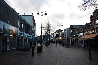
Bilston is a market town in the City of Wolverhampton in the West Midlands, England. It is close to the borders of Sandwell and Walsall. The nearest towns are Darlaston, Wednesbury, and Willenhall. Historically in Staffordshire, four wards of Wolverhampton City Council now cover the town. These are Bilston South and Bilston North, which almost entirely comprise parts of the historic Borough of Bilston and Ettingshall North and Ettingshall South and Spring Vale, which comprise a part of Bilston and other parts of Wolverhampton. The town had a population 34,639 at the 2021 Census.

The Metropolitan Borough of Dudley is a metropolitan borough of West Midlands, England. It was created in 1974 following the Local Government Act 1972, through a merger of the existing Dudley County Borough with the municipal boroughs of Stourbridge and Halesowen.

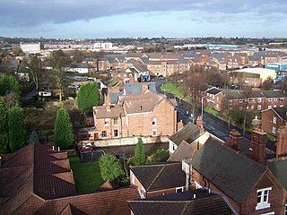
Brierley Hill is a town and electoral ward in the Metropolitan Borough of Dudley, West Midlands, England, 3 miles (4.8 km) south of Dudley and 1 mile (1.6 km) north of Stourbridge. Part of the Black Country and in a heavily industrialised area, it has a population of 13,935 at the 2011 census. It is best known for glass and steel manufacturing, although the industry has declined considerably since the 1970s. One of the largest factories in the area was the Round Oak Steelworks, which closed down and was redeveloped in the 1980s to become the Merry Hill Shopping Centre. Brierley Hill was originally in Staffordshire.
Sedgley is a town in the north of the Dudley district, in the county of the West Midlands, England.

Penn is an area divided between the City of Wolverhampton and South Staffordshire district. The population of the Wolverhampton Ward taken at the 2011 census was 12,718. Originally, it was a village in the historic county of Staffordshire.
The West Midlands region straddles the historic borders between the counties of Warwickshire, Staffordshire in the north, and Worcestershire in the south.

Coseley is a village in the Dudley district, in the county of the West Midlands, England. It is situated three miles north of Dudley itself, on the border with Wolverhampton and Sandwell. It falls within the Tipton and Wednesbury parliamentary constituency.
Lanesfield is a district now within the boundaries of Wolverhampton, specifically in the city council's Spring Vale ward. Lanesfield lies within the Ancient Manor of Sedgley and was a rural village for many years until the growth of the Black Country's industries. Lanesfield's name originates from the Lane family who lived where the area now stands. Originally, Lanesfield was known as Lane's Field.
Goldthorn Park is a suburb of Wolverhampton, West Midlands. It is situated 1½ miles south of the city centre within the Blakenhall ward. It mostly consists of private houses built from the 1930s onwards.

Ettingshall is an area of Wolverhampton, West Midlands, England. It lies within two wards of Wolverhampton City Council: Ettingshall North and Ettingshall South and Spring Vale. The population of Ettingshall taken at the 2011 census was 13,482.
The County Borough of Dudley was a local government district in the English Midlands from 1865 to 1974. Originally a municipal borough, it became a county borough in 1889, centred on the main town centre of Dudley, along with the suburbs of Netherton and Woodside. Although surrounded by Staffordshire, the borough was associated with Worcestershire for non-administrative purposes, forming an exclave of the county until 1966, when it was transferred to Staffordshire after an expansion of the borough boundaries. Following local government reorganization in 1974, Dudley took in the boroughs of Halesowen and Stourbridge to form the present-day Metropolitan Borough of Dudley, in the newly formed West Midlands county.
Seisdon was a rural district in Staffordshire, England from 1894 to 1974. It lay to the west of Wolverhampton and was formed under the Local Government Act 1894 based on the Seisdon rural sanitary district.
Bilston was a parliamentary constituency centred on the town of Bilston in what is now the southeast of the city of Wolverhampton in the West Midlands. It returned one Member of Parliament (MP) to the House of Commons of the Parliament of the United Kingdom.

Tipton Green is the central area of Tipton, a town in the West Midlands of England. It was heavily developed for heavy industry and housing during the 19th century, as Tipton was one of the most significant towns during the Industrial Revolution. Tipton Green is one of three electoral wards covering Tipton for Sandwell Metropolitan Borough Council. The population of this Sandwell ward taken at the 2011 census was 12,834. It is represented by three Labour councillors.
Woodcross is a residential area of Wolverhampton, West Midlands, England. The area traditionally existed within the boundaries of Sedgley and later Coseley until 1966.
Sedgley urban district was a local government district within Staffordshire, which was created in 1894 from the western half of the manor of Sedgley.
