Kashmir Division

Last updated
Kashmir Division
Kashmir border.JPG
Kashmir Division (bordered orange) shown within the wider Kashmir region
Country India (Claimed by Pakistan)
Union territory Jammu and Kashmir
Districts Anantnag, Baramulla, Budgam, Bandipore, Ganderbal, Kupwara, Kulgam, Pulwama, Shopian and Srinagar.
Capital Srinagar
Historical divisions
List
  • Kamraz (North Kashmir) [1]
  • Yamraz (Central Kashmir) [1]
  • Maraz (South Kashmir) [1]
Government
  Type Division
   Divisional Commissioner Pandurang Kondbarao Pole
Area
  Total15,948 km2 (6,158 sq mi)
Dimensions
  Length135 [2]  km (83.885 mi)
  Width32 [2]  km (19.884 mi)
Elevation
1,620 [2]  m (5,314 ft)
Population
 (2011 [3] )
  Total6,888,475 [3]
  Density431.93/km2 (1,118.7/sq mi)
Demonym(s) Kashmiris, Koshur
Ethnicity and language
  Languages Kashmiri, Urdu, Hindi, [4] English, [5] Pahari-Pothwari, Gojri, Shina [6]
  Ethnic groups Kashmiri, Pahari, Gujar, Shina
  Religion (2011 [7] )96.41% Islam,
2.45% Hinduism,
0.81% Sikhism,
0.17% Christianity
Time zone UTC+5:30 (IST)
Vehicle registration JK
Highest peak Machoi Peak (5458 metres)
Largest lake Wular lake(260 km2 (100 sq mi)) [8]
Longest river Jhelum river(725 kilometres) [9]
Website http://kashmirdivision.nic.in/

The Kashmir Division is a revenue and administrative division mostly constituting of the Kashmir Valley of Jammu and Kashmir. It borders Jammu Division to the south and the union territory of Ladakh to the east, while the Line of Control forms its boundary with the Pakistani-administered territories of Gilgit−Baltistan and Azad Jammu and Kashmir to the north and west.

Contents

Srinagar is its main city and also the summer capital of the Jammu and Kashmir. Other main cities are Anantnag, Baramulla, Sopore and Pulwama.

Districts

The Indian administrative districts for the Kashmir Valley were reorganised in 1968, [10] and 2006, [11] each time subdividing existing districts. Kashmir Division currently consists of the following ten districts:

Name of
district
HQAreaPopulation [12]
Total
(km2)
Total
(sq mile)
Rural
(km2)
Urban
(km2)
2001
census
2011
census
Anantnag Anantnag 3,5741,3803,475.898.2 [13] 778,4081,078,692
Kulgam Kulgam 410158360.249.8 [14] 394,026424,483
Pulwama Pulwama 1,0864191,047.538.6 [15] 441,275560,440
Shopian Shopian 312120306.65.4 [16] 211,332266,215
Budgam Budgam 1,3615251,312.049.1 [17] 607,181753,745
Srinagar Srinagar 1,9797641,684.4294.5 [18] 1,027,6701,236,829
Ganderbal Ganderbal 259100233.625.4 [19] 217,907297,446
Bandipore Bandipore 345133295.449.6 [20] 304,886392,232
Baramulla Baramulla 4,2431,6384,179.463.6 [21] 843,8921,008,039
Kupwara Kupwara 2,3799192,331.747.3 [22] 650,393870,354
Total15,9486,15815,226.4721.55,476,9706,888,475

Demographics

Religion

Religions in Kashmir Division (2011) [23]

   Islam (96.41%)
   Hinduism (2.45%)
   Sikhism (0.81%)
   Christianity (0.17%)
  Others (0.02%)
  Not Stated (0.14%)

The Kashmir division is largely Muslim (96.41%) with a small Hindu (2.45%) and Sikh (0.81%) population. [23] Among Muslims, about 10% are Shias, remaining being Sunni. Majority of the population is made up of ethnic Kashmiris, with a significant minority of Gujjars and Bakarwals.

Language

Kashmir division: mother-tongue of population, according to the 2011 Census. [24]

   Kashmiri (85.50%)
   Gojri (6.27%)
   Pahari (3.86%)
   Hindi (1.36%)
  Others (3.01%)

The majority of the population speaks Kashmiri (85.50%), while the remainder speaks either Gujari, Pahari or Hindi. [12]

Urdu is also widely understood as a literary language in Kashmir due to it being a medium of instruction in schools. [10] [12]

Related Research Articles

Jammu and Kashmir (state) 1954–2019 state administered by India

Jammu and Kashmir was a region formerly administered by India as a state from 1954 to 2019, constituting the southern and southeastern portion of the larger Kashmir region, which has been the subject of a dispute between India, Pakistan and China since the mid-20th century. The underlying region of this state were parts of the former princely state of Jammu and Kashmir, whose western districts, now known as Azad Kashmir, and northern territories, now known as Gilgit-Baltistan, are administered by Pakistan. The Aksai Chin region in the east, bordering Tibet, has been under Chinese control since 1962.

Anantnag district District of Jammu and Kashmir, India

Anantnag district is a district in the Indian union territory of Jammu and Kashmir. It is one of ten districts which make up the Kashmir Valley. The district headquarters is Anantnag city. As of 2011, it was the third most populous district of Jammu and Kashmir, after Jammu and Srinagar.

Baramulla district District in Jammu and kashmir, India

Baramulla district or Varmul is one of the 20 districts in the Indian union territory of Jammu and Kashmir. Baramulla town is the administrative headquarters of this district. The district covered an area of 4,588 km2 (1,771 sq mi) in 2001, but it was reduced to 4,243 km2 (1,638 sq mi) at the time of 2011 census. In 2016, the district administration said that the area was 4,190 km2 (1,620 sq mi).

Pulwama district District

The Pulwama district is a district in the Indian Union territory of Jammu and Kashmir, located in the south of Srinagar. The district headquarters of Pulwama district are located in Pulwama city.

Baramulla, also known as Varmul, is a city and a municipality in the Baramulla district in the Indian union territory of Jammu and Kashmir. It is also the administrative headquarters of the Baramulla district. It is on the bank of the Jhelum River downstream from Srinagar, the capital of Jammu and Kashmir, India.

Anantnag City in Jammu and Kashmir, India

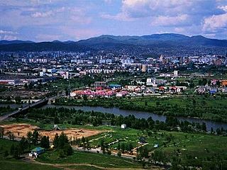
Anantnag, also called Islamabad, is the administrative headquarters of the Anantnag district in the Indian union territory of Jammu and Kashmir. It is located at a distance of 53 kilometres from the union territory's capital Srinagar. It is the third largest city in Jammu and Kashmir after Srinagar and Jammu with an urban agglomerate population of 159,838 and municipal limit population of 109,433.

Sopore, known as Suyyapur in antiquity, is a town in the Baramulla district of Jammu and Kashmir, India. It is 45 km (28 mi) north-west of Srinagar, and 16 km (10 mi) north-east from the city of Baramulla.

Awantipora Town in Jammu and Kashmir, India

Awantipora or Avantipur or Aavantipur, known as Woontpor in Kashmiri, is a town on the banks of the river Jhelum in the Pulwama district of the Indian union territory of Jammu and Kashmir. It is on the Jammu-Srinagar National Highway, south of Srinagar and north of Anantnag. Awantipora was named after the Kashmiri king Avantivarman and has the ruins of two 9th century Hindu temples built by him.

Banihal Town in Jammu and Kashmir, India

Banihal is a town and a notified area committee in Ramban district in the Indian union territory of Jammu and Kashmir. It is a rural and hilly area with Kamirwah being one of the most spectacular hills. It is located about 35 km (22 mi) away from Qazigund of Anantnag district on NH 44. However, the distance between Banihal and Qazigund is only 18 km by train on the new railway line which is much shorter than the road. The most common language spoken in the region is Kashmiri; Urdu, Gujjari, English being other familiar languages.

Bijbehara Town in Jammu and Kashmir

Bijbehara is a town and a notified area committee in Anantnag district of the Indian administered union territory of Jammu and Kashmir. It is located on NH 44, and jehlum bank. Bijbehara town is also known as "Town of Chinars" because of a number of Chinars there especially two Chinar gardens. Bijbehara is the home to oldest chinar tree in the region. The town is situated about 45 km (28 mi) from the summer capital of union territory of Jammu and Kashmir, Srinagar.

Kokernag Sub-District and Town in Anantnag, Jammu and Kashmir

Kokernag is a sub-district town and a notified area committee in Breng Valley, Anantnag district in the Indian union territory of Jammu and Kashmir. The place is known for the botanical garden, pristine freshwater springs and rainbow trout farm. It is 25.3 km from Anantnag via NH244. It is one of the most popular weekend getaways from the state capital Srinagar.

Kulgam, known as Kolgom in Kashmiri, is a town, administrative division, and capital of the Kulgam district in the Indian union territory of Jammu and Kashmir. It is located at a distance of 67 km (42 mi) from the summer state capital of Jammu and Kashmir, Srinagar. The city is divided into 16 electoral wards that has population of 23,584, of which 12,605 are males while 10,979 are females.

Kupwara is a town and a municipal council in Kupwara district in the Indian union territory of Jammu and Kashmir.

Kupwara district District of Jammu and Kashmir in India

Kupwara district, Kupwara is one of the 10 districts located in the Kashmir Valley region of Jammu and Kashmir, India. The river Kishenganga, originating from the Himalayas, flows through the outer areas of the district from east to west.

Budgam district District of Jammu and Kashmir in India

Budgam district is a district in the Indian-administered union territory of Jammu and Kashmir. Created in 1979 with its headquarters at Budgam, it is the district with the largest population of Shias in the Kashmir valley..

Sadura is a village located in Anantnag district in the Indian administered union territory of Jammu and Kashmir. It has a railway station which lies on Banihal-Anantnag railway line.

Sifan is a village in Anantnag tehsil in Anantnag district in Jammu and Kashmir, India.

Jammu and Kashmir (union territory) Region administered by India

Jammu and Kashmir is a region administered by India as a union territory and consisting of the southern portion of the larger Kashmir region, which has been the subject of a dispute between India and Pakistan since 1947, and between India and China since 1962. The Line of Control separates Jammu and Kashmir from the Pakistani-administered territories of Azad Kashmir and Gilgit-Baltistan in the west and north. It lies to the north of the Indian states of Himachal Pradesh and Punjab and to the west of Ladakh, which is also subject to the dispute as a part of Kashmir, and administered by India as a union territory.

Budgam, known as Badgom in Kashmiri, is a town in Budgam district in the union territory of Jammu and Kashmir, India. In the 2001 census, it was recorded as having a notified area committee, but by the 2011 census it had a municipal committee.

References

  1. 1 2 3 "Spoken Kashmiri: A Language Course". Archived from the original on 29 November 2016. Retrieved 1 February 2017.
  2. 1 2 3 "Vale of Kashmir | valley, India". Encyclopædia Britannica . Archived from the original on 4 August 2016. Retrieved 2016-07-08.
  3. 1 2 "Demography of Jammu and Kashmir State". J&K; Envis Centre, Department of Ecology Environment and Remote Sensing J&K. Archived from the original on 22 February 2018. Retrieved 18 December 2016.
    This used the Digest of Statistics, 2011-12 for its data source.
  4. "The Jammu and Kashmir Official Languages Act, 2020" (PDF). The Gazette of India. Retrieved 27 September 2020.
  5. "Parliament passes JK Official Languages Bill, 2020". Rising Kashmir. 23 September 2020. Retrieved 23 September 2020.
  6. Shina, bolbosh
  7. "Religion Data of Census 2011: XV Jammu and Kashmir", Centre for Policy Studies, India, Chennai and Delhi, 29 February 2016, archived from the original on 24 January 2021, retrieved 6 March 2021
  8. "Wular Lake | lake, India". Encyclopædia Britannica . Archived from the original on 2 February 2017. Retrieved 1 February 2017.
  9. "Jhelum River | river, Asia". Encyclopædia Britannica . Archived from the original on 2 February 2017. Retrieved 1 February 2017.
  10. 1 2 Behera, Navnita Chadha (2006). Demystifying Kashmir. Pearson Education India. p. 28. ISBN   978-8131708460.
  11. "Jammu and Kashmir to have eight new districts". Indo-Asian News Service. 6 July 2006.
  12. 1 2 3 Census of India 2011, Provisional Population Totals Paper 1 of 2011 : Jammu & Kashmir. Office of the Registrar General & Census Commissioner, India (Report).
    Annexure V, Ranking of Districts by Population Size, 2001 - 2011 (Report).
  13. District Census Handbook Anantnag, Part A (PDF). Census of India 2011 (Report). July 2016. p. 9. Retrieved 21 November 2020.
    District Census Handbook Anantnag, Part B (PDF). Census of India 2011 (Report). July 2016. pp. 12, 22. Retrieved 21 November 2020.
  14. District Census Handbook Kulgam, Part A (PDF). Census of India 2011 (Report). July 2016. p. 10. Retrieved 21 November 2020.
    District Census Handbook Kulgam, Part B (PDF). Census of India 2011 (Report). 16 June 2014. pp. 12, 22. Retrieved 21 November 2020.
    Part B page 12 says the area of the district is 404 km2, but page 22 says 410 km2.
  15. District Census Handbook Pulwama, Part B (PDF). Census of India 2011 (Report). 16 June 2014. pp. 12, 22. Retrieved 21 November 2020.
  16. District Census Handbook Shupiyan, Part A (PDF). Census of India 2011 (Report). 16 June 2014. p. 10. Retrieved 21 November 2020.
    District Census Handbook Shupiyan, Part B (PDF). Census of India 2011 (Report). 16 June 2014. pp. 12, 22. Retrieved 21 November 2020.
    Part B pages 12 and 22 say the district area is 312.00 km2, but Part A page 10 says 307.42 km2.
  17. District Census Handbook Badgam, Part A (PDF). Census of India 2011 (Report). July 2016. pp. 10, 46. Retrieved 21 November 2020.
    District Census Handbook Badgam, Part B (PDF). Census of India 2011 (Report). 16 June 2014. pp. 11, 12, 22. Retrieved 21 November 2020.
    Part A says the district area is 1371 km2, Part B says 1371 km2 (page 11) and 1361 km2 (page 12s and 22).
  18. District Census Handbook Srinagar, Part A (PDF). Census of India 2011 (Report). July 2016. pp. 11, 48. Retrieved 21 November 2020.
    Part A page 48 says the district area was 2228.0 km2 in 2001 and 1978.95 km2 in 2011.
  19. District Census Handbook Ganderbal, Part B (PDF). Census of India 2011 (Report). July 2016. pp. 11, 12 and 22. Retrieved 21 November 2020.
    Part B page 11 says the district area is 393.04 km2, but pages 12 and 22 say 259.00 km2.
  20. District Census Handbook Bandipora, Part A (PDF). Census of India 2011 (Report). July 2016. pp. 10, 47. Retrieved 21 November 2020.
    District Census Handbook Bandipora, Part B (PDF). Census of India 2011 (Report). 16 June 2014. pp. 11, 20. Retrieved 21 November 2020.
  21. District Census Handbook Baramulla, Part A (PDF). Census of India 2011 (Report). July 2016. p. 11. Retrieved 21 November 2020.
    District Census Handbook Baramulla, Part B (PDF). Census of India 2011 (Report). 16 June 2014. p. 22. Retrieved 21 November 2020.
  22. District Census Handbook Kupwara, Part A (PDF). Census of India 2011 (Report). July 2016. p. 7. Retrieved 21 November 2020.
    District Census Handbook Kupwara, Part B (PDF). Census of India 2011 (Report). 16 June 2014. pp. 11, 12. Retrieved 21 November 2020.
  23. 1 2 "Population by religion community – 2011". Census of India, 2011. The Registrar General & Census Commissioner, India. Archived from the original on 25 August 2015.
  24. C-16 Population By Mother Tongue – Jammu & Kashmir (Report). Office of the Registrar General & Census Commissioner, India. Retrieved 18 July 2020.

Coordinates: 34°02′00″N74°40′00″E / 34.0333°N 74.6667°E / 34.0333; 74.6667