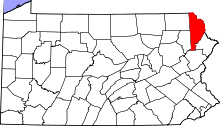
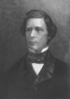
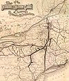
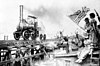
Marker title Image Date dedicated Location Marker type Topics Cushetunk May 28, 1947 SR 1004 N of Milanville (MISSING) Roadside American Revolution, Early Settlement, Government & Politics, Government & Politics 18th Century, Native American David Wilmot July 27, 1948 PA 670 1.6 mi. NW of PA 90, Honesdale (Missing) 41°36′46″N 75°17′02″W / 41.61265°N 75.28388°W / 41.61265; -75.28388 (David Wilmot ) Roadside Government & Politics, Government & Politics 19th Century, Writers David Wilmot May 29, 1947 395 Old Wayne St., S of Sugar St., off Pa. 670 at Bethany, not accessible from "new" Wayne St. (a private drive) Roadside African American, Government & Politics, Government & Politics 19th Century Delaware & Hudson Canal May 28, 1947 Main St. (US 6) & 8th St., at historical society, Honesdale 41°34′20″N 75°15′20″W / 41.57222°N 75.25555°W / 41.57222; -75.25555 (Delaware & Hudson Canal ) Roadside Canals, Coal, Navigation, Railroads, Transportation Dorflinger Glass Works June 28, 1951 Main St. (US 6 - Texas Palmyra Hwy.) & Elizabeth St. at S end of White Mills 41°31′35″N 75°12′13″W / 41.52642°N 75.20353°W / 41.52642; -75.20353 (Dorflinger Glass Works ) Roadside Business & Industry, Glass Honesdale April 9, 1948 Grandview Ave. (US 6) near #20, at billboard, SE of Honesdale 41°33′23″N 75°14′26″W / 41.55642°N 75.24068°W / 41.55642; -75.24068 (Honesdale ) Roadside Canals, Cities & Towns, Coal, Professions & Vocations, Transportation Honesdale April 9, 1948 W Park St. (US 6) & Meadow Ln. west of Honesdale (on left heading west) 41°34′39″N 75°16′21″W / 41.57756°N 75.27254°W / 41.57756; -75.27254 (Honesdale ) Roadside Cities & Towns Lincoln Nomination August 26, 1968 115 9th St., Honesdale 41°34′24″N 75°15′21″W / 41.57336°N 75.25586°W / 41.57336; -75.25586 (Lincoln Nomination ) Roadside Abraham Lincoln, Government & Politics, Government & Politics 19th Century Pennsylvania n/a PA 191 between PA 370 and the state line (Missing) Roadside Government & Politics, Government & Politics 17th Century, William Penn Samuel Meredith July 28, 1948 Great Bend Turnpk. (PA 371) & Bethany Turnpk. (PA 670) at fork, Pleasant Mount (near Welcome sign) 41°44′24″N 75°26′04″W / 41.74°N 75.43433°W / 41.74; -75.43433 (Samuel Meredith ) Roadside American Revolution, Government & Politics, Government & Politics 18th Century Samuel Meredith October 21, 1949 PA 371/670 (Great Bend Trnpk.) & Belmont and Easton Trnpk. at Belmont Corner W of Pleasant Mount 41°44′26″N 75°27′22″W / 41.74051°N 75.45615°W / 41.74051; -75.45615 (Samuel Meredith ) Roadside Government & Politics, Government & Politics 18th Century Sarah Mary Benjamin May 30, 1992 Old Newburgh Trnpk. / Great Bend Trnpk. (PA 371) at Brannigan Rd., just S of Pleasant Mount (West Hill), near N-E PA Phone Co. 41°44′24″N 75°26′21″W / 41.73999°N 75.43925°W / 41.73999; -75.43925 (Sarah Mary Benjamin ) Roadside American Revolution, Military, Women Stourbridge Lion May 28, 1947 US 6 / PA 191 (Main St.) at Park St., Honesdale, by bridge 41°34′37″N 75°15′30″W / 41.57693°N 75.25835°W / 41.57693; -75.25835 (Stourbridge Lion ) Roadside Railroads, Transportation Stourbridge Lion n/a Main St. (US 6) & 8th St., at historical soc., Honesdale 41°34′20″N 75°15′20″W / 41.57223°N 75.25554°W / 41.57223; -75.25554 (Stourbridge Lion ) Roadside Railroads, Transportation Wayne County July 8, 1981 County Courthouse, 925 Court St., Honesdale 41°34′28″N 75°15′15″W / 41.57455°N 75.25407°W / 41.57455; -75.25407 (Wayne County ) City Government & Politics, Government & Politics 18th Century