Related Research Articles

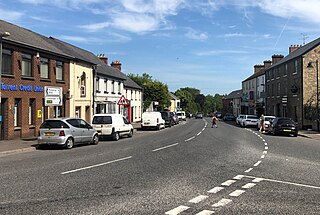
Royal Hillsborough, more commonly known simply as Hillsborough, is a village and civil parish in County Down, Northern Ireland, 19 km (12 mi) from the city of Belfast. It is within the Lisburn and Castlereagh District Council area. The village is noted for its Georgian architecture. It is home to Hillsborough Castle, the British royal family's official residence in Northern Ireland, and residence of the British Secretary of State for Northern Ireland.
A townland is a small geographical division of land, historically and currently used in Ireland and in the Western Isles in Scotland, typically covering 100–500 acres (40–202 ha). The townland system is of Gaelic origin, antedating the Norman invasion, and most have names of Irish origin. However, some townland names and boundaries come from Norman manors, plantation divisions, or later creations of the Ordnance Survey. The total number of inhabited townlands in Ireland was 60,679 in 1911. The total number recognised by the Irish Place Names database as of 2014 was 61,098, including uninhabited townlands, mainly small islands.

Dundonald is a large settlement and civil parish in County Down, Northern Ireland. It lies east of Belfast and is often considered a suburb of the city. It is home to the Ulster Hospital, Dundonald International Ice Bowl, Dundonald Omnipark, has a Park and Ride facility for the Glider, access to the Comber Greenway and several housing developments. John de Courcey established a keep including a motte-and-bailey in the 12th century. This is known as Moat Park and can be accessed from Church Green, Comber Road and the Upper Newtownards Road.

Ballywalter is a village or townland and civil parish in County Down, Northern Ireland. It is on the east coast of the Ards Peninsula between Donaghadee and Ballyhalbert. Ballywalter was formerly known as Whitkirk as far back as the 12th century. It had a population of 2,027 people in the 2011 census.
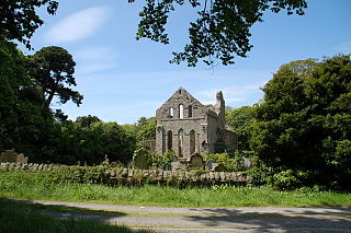
Greyabbey or Grey Abbey is a small village, townland and civil parish located on the eastern shores of Strangford Lough, on the Ards Peninsula in County Down, Northern Ireland.
Donaghmore is a village, townland and civil parish in County Tyrone, Northern Ireland, about five kilometres (3 mi) north-west of Dungannon. In the 2011 Census it had a population of 1,122 people. The village is beside the River Torrent, formerly known as the Torrent Flow.

Tullylish is a small village, townland and civil parish in County Down, Northern Ireland. It sits on the River Bann, along the main road between the towns of Banbridge and Portadown. In the 2001 Census it had a population of 105 people. It lies within the civil parish of Tullylish and Banbridge District.

Ballykinler, often transcribed as Ballykinlar, is a village and civil parish in County Down, Northern Ireland. It lies 12 kilometres south west of Downpatrick, in the parish of Tyrella and Dundrum. In the 2001 census it had a population of 348 people. It is within the Newry, Mourne and Down area and runs parallel to the Irish Sea coast. Located within the Lecale Coast Area of Outstanding Natural Beauty, the village is surrounded by low drumlins and marshes. It is also the site of a former British Army base known as Abercorn Barracks.

Carrickfergus is a barony in County Antrim, Northern Ireland. It is bounded on the south-east by Belfast Lough, and otherwise surrounded by the barony of Belfast Lower. It is coextensive with the civil parish of Carrickfergus or St Nicholas and corresponds to the former county of the town of Carrickfergus, a county corporate encompassing Carrickfergus town.
Maghera is a parish in County Londonderry, Northern Ireland. It is bordered by the parishes of Ballynascreen, Ballyscullion, Desertmartin, Dungiven, Kilcronaghan, Killelagh, Magherafelt, Tamlaght O'Crilly, and Termoneeny. As a civil parish it lies within the former barony of Loughinsholin and as an ecclesiastical parish it lies within the Church of Ireland Diocese of Derry and Raphoe.

Lecale Lower is a barony in County Down, Northern Ireland. It lies to the east of the county with Strangford Lough to its north and the Irish Sea to its right. It is bordered by five other baronies: Lecale Upper to the south; Ards Upper to the north-east just across the mouth of Strangford Lough; Dufferin to the north; Castlereagh Upper to the north-west; and Kinelarty to the west.
Lecale Upper is a barony in County Down, Northern Ireland. To its south lies the Irish Sea, and it is bordered by three other baronies; Lecale Lower and Kinelarty to the north; and Iveagh Upper, Lower Half to the west.
Bangor is a civil and ecclesiastical parish in County Down, Northern Ireland. It is located in the north of the Ards Peninsula, consisting of 30 townlands, twenty-two and a half of which lie in the barony of Ards Lower, with seven and a half lying within that of Castlereagh Lower. Its ancient monastery was of ecclesiastical importance.

Clontycarnaghan is a townland in the civil parish of Templeport, County Cavan, Ireland. It lies in the Roman Catholic parish of Templeport and barony of Tullyhaw.

Tirnawannagh is a townland in the civil parish of Templeport, County Cavan, Ireland. It lies in the Roman Catholic parish of Corlough and barony of Tullyhaw.
References
- ↑ "Parishes of Ulster". Ulster Ancestry. Retrieved 31 December 2008.
- ↑ "Civil parishes of County Down". IreAtlas Townlands Database. Retrieved 19 May 2015.
